By Frank Strait
Severe Weather Liaison
S.C. State Climate Office
The National Hurricane Center (NHC) is monitoring an area of low pressure currently centered near Kingsville, Texas. It will move out over the northwestern Gulf tonight and spend about 24 hours centered over the 82-84°F waters of that area. NHC is calling for this to become a tropical storm by tomorrow morning, so they need to start issuing advisories. It’s not a tropical cyclone yet, so they’re calling it Potential Tropical Cyclone One.
It will move across the Gulf tomorrow and into the lower Mississippi Valley tomorrow night. So, it’s no problem for us, right? I wish it were that easy.
A cold front currently over the Plains and upper Midwest will push southeastward over the next 24 hours and into the southeastern states by Friday. The wind south of the approaching front will push this disturbance our way; it will be named Arthur if it becomes a tropical storm, as expected. There are questions about when it will move through South Carolina, its exact track, and the answers will determine the impacts at any given point.
The remnants of the storm are likely to move through sometime between late Thursday and Friday. As it does, we’ll see soaking rain and thunderstorms. There will be at least a low-end risk for severe storms with isolated tornadoes. That risk will be higher if it hits us during the day when the sun is out, making the atmosphere more unstable. That could be Thursday afternoon if it moves faster or Friday if it moves much slower than expected.
The rain would put another dent in our drought, with the potential for 1-3 inches and locally higher amounts; a slower-moving system could bring more rain. Parts of the state could see localized flash flooding; the most likely candidate to win big in the heavy-rain campaign is the Upstate, especially the higher ground.
The front pushing the ‘perhaps Arthur’ toward us will move through later Friday into Friday night with another round of spotty showers and thunderstorms. That front may trigger more showers into Saturday over the Coastal Plain, at least for the first part of the day. The upcoming weekend looks nice otherwise: dry, with reduced humidity.
Hopefully, PTC One won’t be a big deal for us, with only a dent in our drought left behind by this feature come Saturday and no other dents. However, with the potential for isolated tornadoes later this week, it’s a good time to review severe storm and tornado safety rules. It’s also a reminder that we’re in the hurricane season, and you ought to be stocking your hurricane kits. You can find advice on stocking those kits and other storm prep from hurricane.sc.
WEATHER ALERT: Tropics Come To Life With PTC One
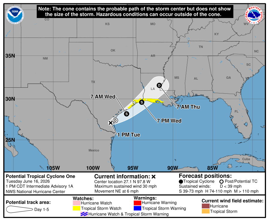 The latest forecast uncertainty cone graphic for Potential Tropical Cyclone One, including current watches and warnings in effect. Remember that the cone indicates the area where the center of the storm is likely to track and does not indicate where impacts will occur.