


By Frank Strait
Severe Weather Liaison
S.C. State Climate Office
Key Points:
-The rain we’re seeing today may end as a little wet snow, sleet or freezing rain late tonight and early Thursday over the northern part of the state. A few spots could see a small accumulation.
-The impacts of any wintry mix that we see would be limited to slick spots, mainly on elevated road surfaces.
Good afternoon. Before you yell, “NO, NOT AGAIN,” this is just a chance for a low-end event. Do not gallop to the store for milk sandwich ingredients. This only applies to the far northern part of the state, anyway. Other areas down to around I-20 might see a brief flurry or two but with no impacts. The rest of y’all can just chill … through this weekend, literally.
The trigger for the rain we’re seeing today is a cold front and attendant upper-level disturbance, which will move offshore tonight. However, a second trailing upper-level disturbance will move through later tonight and early Thursday, and it looks like enough moisture will be left over for this second feature to cause some light precipitation.
These ‘cold air chasing moisture’ situations produce winter precipitation far less often than they do, but this one has a better chance than most.
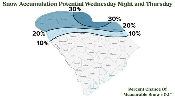
So, don’t be surprised to see snow falling when you wake up Thursday morning across the Upstate, Catawba Region, and upper Pee Dee.
There’s also a chance that we see temperatures fall to freezing late tonight over the upper Pee Dee region before they do aloft, leading to a bit of freezing rain. Again, not much. Power outages won’t be an issue, but icy bridges might be.
Even if we don’t see anything frozen, some light rain overnight, followed by temperatures at or below freezing toward daybreak, can lead to patchy icy spots. No matter what, be careful Thursday morning and allow extra time for any travel.
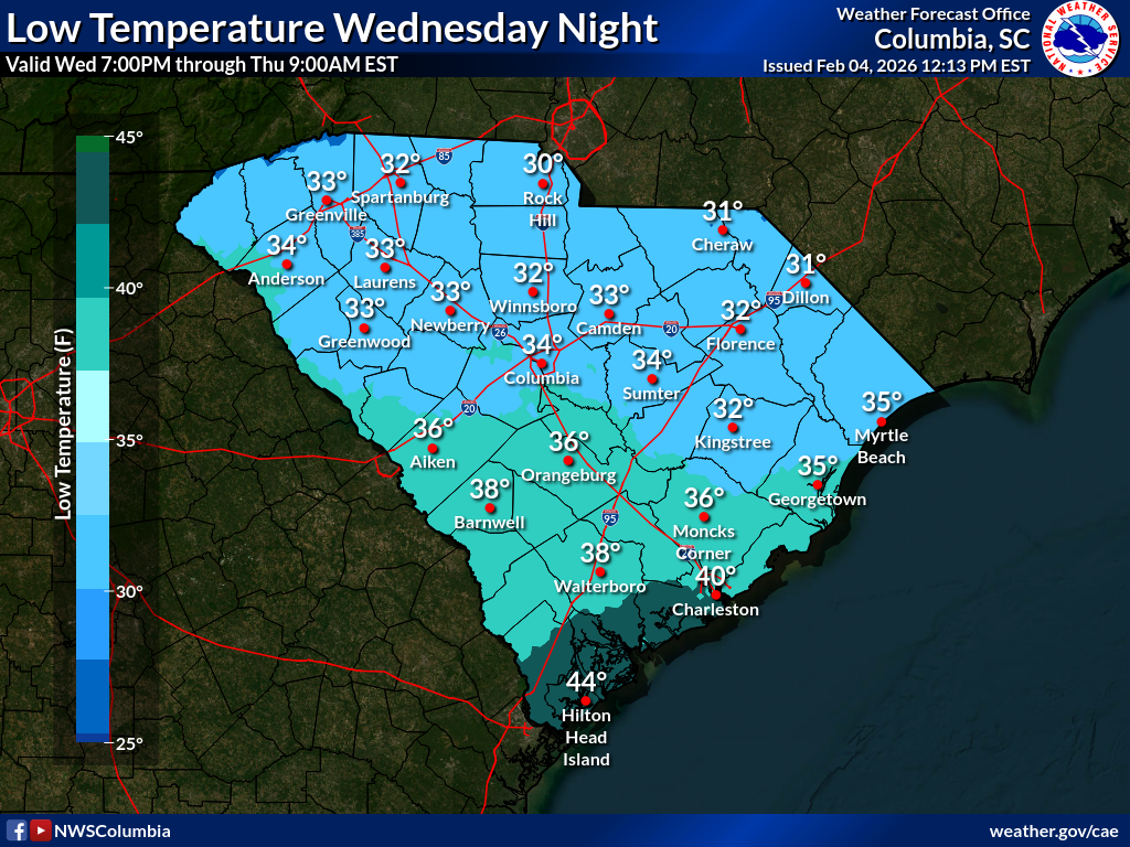
Thursday’s highs mostly be in the 40s across the state. Any snow that accumulates will melt fast.
Kids, don’t get excited. The worst-case scenario is for a delay or an e-learning day. Get your homework done.
We remain cool through this weekend, but a warmer weather pattern is setting up for next week. This report will probably be my last for a while unless a severe storm situation comes up in the warmer pattern. However, winter probably isn’t over. There’s a chance we’ll return to a cold-weather pattern before the end of the month or in early March.


