By Frank Strait
Severe Weather Liaison
S.C. State Climate Office
Hey, y’all! Long time, no Weather Alert. Our weather has been unusually tranquil for months – not good, the result has been a terrible drought, but at least there has been substantial rain over the last week. So, it’s been a minute since you’ve heard from me. Anyway, the time has come to resume routine Weather Alerts on Fridays, because the Atlantic hurricane season will begin on Monday.
The start of the season is the time to look at the seasonal hurricane activity forecast for the Atlantic, and you’ve probably already heard about these in the news. Colorado State University, which has been issuing seasonal hurricane activity forecasts for over 40 years, released its outlook on April 9, and NOAA, the parent federal agency of the National Weather Service, issued its forecast on May 21. Numerous other private and public-sector entities have also issued forecasts.
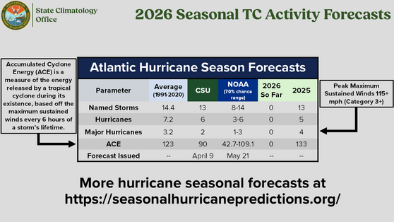
The consensus is that this hurricane season will be less active than recent years. Hooray! This lessens the Palmetto State’s odds of being impacted by a storm this season. The main reason is that we have an El Niño (warmer-than-average water temperatures across the equatorial central and eastern Pacific Ocean) getting underway. During El Niño, upper-level westerly winds shift northward over the eastern Pacific and West Coast, and shift southward over much of the Atlantic Basin. When you have westerly winds aloft over the tropics, you have more vertical wind shear because the lower-level winds in the tropics (the Trade Winds) are usually from the east-northeast. Tropical cyclones hate vertical wind shear because it tears them apart; the top of the storm is carried one way while the bottom is carried another. So, a tropical cyclone struggles to maintain itself and intensify when vertical wind shear is strong. El Niño years also tend to result in a relatively dry air mass over the Atlantic tropics, a tough environment for tropical cyclones to operate in.
Another primary reason for the low expectations is that the waters of the tropical Atlantic and Caribbean Sea have cooled over the last few years and are now mostly cooler than average. Cooler ocean water means less fuel is available for tropical cyclones that form. There are other factors seasonal forecasters consider, including computer model output, other long-period atmospheric cycles, and rainfall over Africa’s Sahel region.
We don’t have any features threatening to develop in the Atlantic tropics now, which is what we expect in May. Developments happen in May from time to time, and we have had a rash of them in recent years. On average, we see a May storm about every 7 years (13 May storms in the official records going back to 1851).
However, the Atlantic Basin could turn active during June. If you’ve been a subscriber for a while, you recall that one tool forecasters use to track the potential for medium- to long-range (over a week to around six weeks out) tropical cyclone activity is the state of the Madden-Julian Oscillation (MJO). In a nutshell, the MJO is a disturbance that drifts eastward across the world’s tropics and modulates tropical cyclone activity for each region. Its strength varies, but when it’s strong enough, it will cause active and tranquil periods for each tropical cyclone basin. Well, as we begin this year’s hurricane season, the MJO is moving toward a favorable state for tropical cyclone development over the Atlantic Basin.
As a result, some computer models have intermittently shown a tropical cyclone forming in early to mid-June over the regions of the Atlantic Basin favored by climatology: the Caribbean Sea, the Gulf and the southwestern Atlantic. The American GFS, which churns out far more tropical cyclones than actually form, is the main model showing possible development. Most other models indicate little or no chance for tropical development through around June 13. The bottom line here is that the state of the MJO suggests it’s a reasonable possibility that a tropical cyclone could develop in those usual suspect areas over the next few weeks, but that’s all that can be said right now. I think that later, around or after midmonth, brings better chances for a development; the action should be in the East Pacific until then.
We’ll monitor tropical waves currently moving through the Atlantic Basin around 74° and 53° west as they drift westward, along with any others that emerge from Africa, and any cold fronts that move in from the north and become stationary over the climatologically favored areas in the coming weeks for signs of development.
In the meantime, while I’m sure you’re somewhat less tense knowing that we expect a less active hurricane season, the seasonal forecasts should not affect how you prepare. The “it only takes one” cliche applies here. For example, let me take you back to the 1989 hurricane season, when we had only 11 named storms form. Anyone who was here in late 1989 can tell you about Hugo, the last major hurricane to affect our state, which hit in September of that year. The people of South Florida and Louisiana would caution you that the overall quiet season of 1992 (with only seven named storms) brought them Hurricane Andrew, which was a Category 5 hurricane in South Florida and a Category 3 hurricane in Louisiana. So, you should get your hurricane kits stocked and take care of other preseason storm prep work now so that you’re ready for “the one” should South Carolina be the place under assault. As always, you can find hurricane prep tips and advice at hurricane.sc. You have some time; don’t waste it, because they’re not making any more.
Finally, here are the highlights of our weather over the next week:
-A cold front moving through will cause showers near the Savannah River and a thunderstorm in spots this afternoon and evening, while the rest of the state enjoys a respite from the rain with lower humidity.
-Late tonight and Saturday brings another round of badly needed rain, perhaps embedded thunder in the Lowcountry, as the front retreats northward. The rain and clouds keep temperatures down Saturday with highs mostly in the 70s and lower 80s.
-Sunday looks cool (mostly 70s across the state) and mostly dry, the nicer day of the weekend for sure, then look for another round of showers and perhaps thunderstorms Sunday night through Monday. Most places reach the 80s on Monday.
-Another cold front will bring us scattered showers Monday night into Tuesday (there’s some uncertainty on timing).
It’s looking nice for early June on Wednesday and Thursday with mainly sunny days and clear, comfortable nights.
It gets warmer and more humid late next week, and showers become possible starting Friday, though that next chance for rain may hold off until next weekend.
See y’all next Friday!