By Frank Strait
Severe Weather Liaison
S.C. State Climate Office
S.C. Department of Natural Resources
Key Points:
-Our winter storm is underway; roads will be slick over much of the state through Saturday morning.
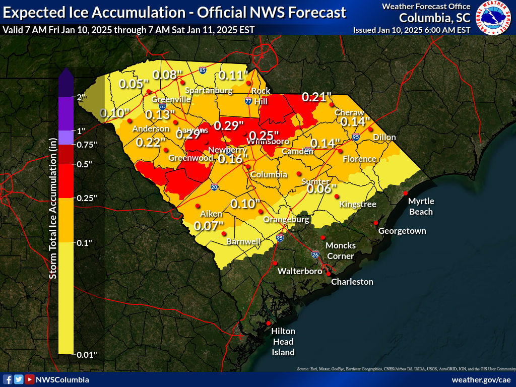
-Ice buildup can cause scattered tree and power line damage in a swath across the southern Upstate, northern Central Savannah River Area, northern Midlands, and upper Pee Dee.
Melting will be slow over the weekend:
-Snow and ice will mostly melt away Saturday afternoon southeast of I-85, but any lingering puddles or slush will refreeze Saturday night and there can be icy patches Sunday morning.
-Lingering snow and ice along and north of I-85 will freeze Saturday night as temperatures fall to the teens. Highs only in the 30s Sunday mean there may still be some slush and meltwater on the roads freezing up again Sunday night and lead to icy patches early Monday.
The winter storm is underway over much of South Carolina. It moved in ahead of schedule along I-20 and even south. The cacophony of ice pellets striking my HVAC compressor unit is quite a distraction as I write this.
Heavy snow and sleet along I-20 and the sleet and snow around Charleston this morning probably won’t be the only surprises we see. Stay on your toes if you have to be out, and be as cautious as you can.
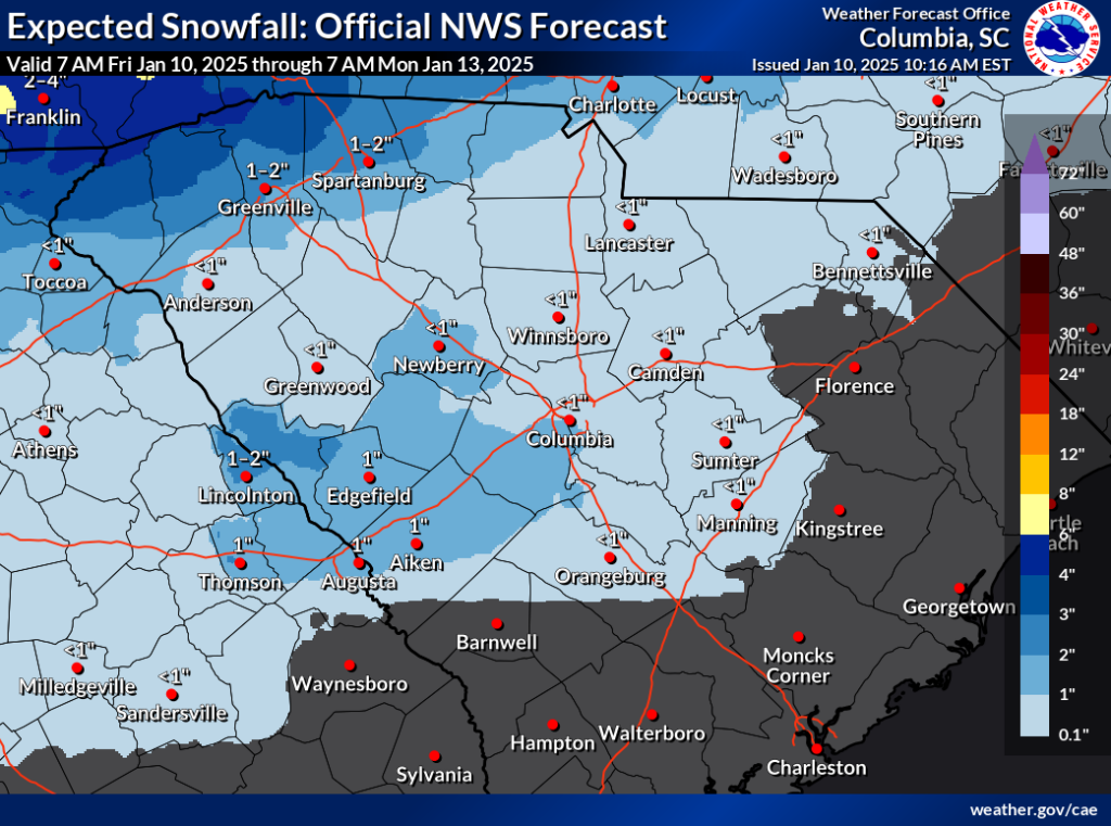
This band of … slop … will cause slippery travel over the I-20 Corridor this afternoon and evening and for much of the Pee Dee. This band should slowly edge northward as the afternoon wears on. I’ve been told we already have numerous wrecks along I-95, I-26, and I-20. Meanwhile, snow is spreading over the Upstate. That will mix with sleet and freezing rain later today and tonight.
Here are the latest snow accumulation and ice buildup forecasts. Both snow and ice have been beefed up near I-20.


The messy mix of snow, sleet, and freezing rain along I-20 should turn to mainly freezing rain later today and eventually to plain rain tonight as it warms above 32°. Further north, things appear to be working out more as expected. Roads will get slick this afternoon and remain slick into Saturday across this area, especially in the areas that see the heaviest wintry slop northwest of I-85.
Power outages and tree damage will be a concern in the area that sees the worst of the freezing rain later today and tonight. This area has been shifted southward a bit since Thursday evening.
The snow and ice will melt slowly this weekend. We’ll get rid of some of it Saturday as it warms up to the 40s, but any lingering slush or standing water on the roads will freeze back up Saturday night as temperatures fall to the high teens and low 20s over most of the state. So, be ready for icy roads early Sunday, especially along and north of I-85, where more snow and sleet will fall. Sunday will be quite cold, with highs only in the 30s where the ice and snow linger and 40s elsewhere, so melting will be slow, and we might still have some slippery spots to contend with Monday morning in the Upstate.
Next week looks dry and chilly. A mainly moisture-starved cold front will move through later Monday or Monday night; some light rain with that feature mainly passing by to our south could clip the Lowcountry. Behind this front, it gets colder again, with highs mainly in the 40s across the state Tuesday through Thursday.
Warmer days are coming on Friday and Saturday before another cold front moves in next weekend. Early signs are that this cold front will have more moisture to work with and cause some rain. However, timing is in question. It looks like the earliest it would arrive would be next Saturday afternoon.


