

By Frank Strait
Severe Weather Liaison
S.C. State Climate Office
S.C. Department of Natural Resources
Key Points:
* A Winter Storm Warning is in effect for the Lowcountry and Allendale County.
* A Winter Weather Advisory is in effect for parts or all of Barnwell, Bamberg, Orangeburg, and Clarendon Counties.
* A Winter Storm Watch is in effect for Williamsburg, Georgetown and Horry Counties.
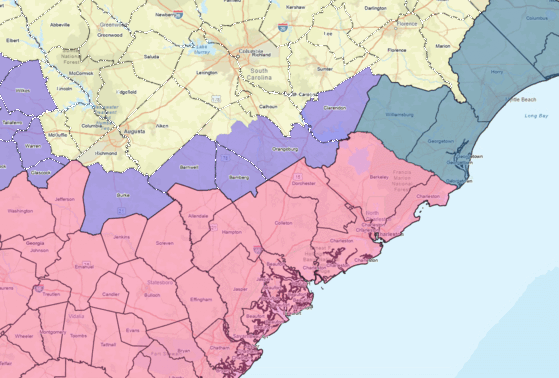
Light Purple: Winter Weather Advisory
Grayish Blue: Winter Storm Watch
* With frigid air in place, this will primarily be a snow event for us Tuesday night and early Wednesday. However, snow will mix with sleet and perhaps freezing rain along the coast. Ice buildup is possible in the Lowcountry, but it won’t be enough to cause tree and power line damage.
* The heaviest snow will occur along the Coastal Plain; much of this area will see 1-3 inches of snow, leading to hazardous travel. Locally higher amounts are possible, and a few spots may see 4-5 inches. However, mixing with sleet and freezing rain will limit the accumulations along the immediate coast.
* Areas along I-20 will see a coating to an inch, which will cause slippery travel.
North of I-20 to I-85, light snow can leave a small accumulation, resulting in slick spots on some roads.
* Along and north of I-85, light snow and flurries will leave little or no accumulation.
* While the confidence level is higher in the forecast now, there can still be changes in the accumulations and resulting impacts that depend on the storm track, storm intensity, and available moisture.
* Confidence is higher on the timing:
–The storm will begin around nightfall Tuesday evening along the Savannah River and spread over the state as the evening wears on.
–It will end from the northwest at around 3 a.m. Tuesday, with the back edge of precipitation reaching the coast by 10 a.m. Wednesday.
The picture we have of the upcoming winter storm is coming into better focus. The storm will primarily affect our Coastal Plain, with lesser effects to the northwest and perhaps very little or no impact along and north of I-85.
I prefer to avoid lengthy model-versus-model discussions here, but the overall trend toward lesser impacts appears to have ended with this morning’s models. The most recent model cycle reversed the trend with a slight tick back toward a more northward storm track, with the storm a bit stronger and pulling in more moisture. It’s too soon to say if that’s a new (and worrisome) trend or just an end to the trend toward lower impacts.
This winter storm is happening because of frigid air in place across the region. It’s likely to be the coldest of this winter. So, you’ll want to dress in layers if you must be out and insulate any exposed pipes or spigots outdoors this evening.
Here’s what I think about our coming storm:
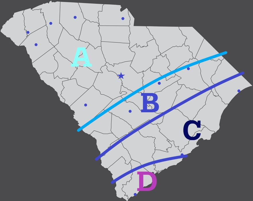
Area A:
This area will see a dusting to an inch of snow Tuesday night; the southern and eastern parts should see more than I-85 and north. The I-85 Corridor and areas northwest may see little or no snow. However, there can locally be an inch (some models indicate over an inch is possible locally) along I-20. There will be some slick spots on the roads and sidewalks Tuesday night and early Wednesday. Despite the return of sunshine Wednesday afternoon, temperatures don’t get much above freezing. So, melting will be slow, and slush and snow may linger on some secondary and back roads into Wednesday night when temperatures fall well below freezing again. That means there may be some icy patches early Thursday, especially in the I-20 Corridor.
Area B:
This area will see ½ to 2 inches of snow; this is also generally from north to south. Most roads will become slippery Tuesday night into Wednesday morning. Limited melting will occur Wednesday afternoon; we’ll have refreezing leading to slick spots Wednesday night into Thursday morning. With Thursday featuring little sunshine and it remains cold, I can’t rule out another minor refreeze event Thursday night into Friday morning, causing isolated icy patches on some back roads.
Area C:
I think this area will see 1-3 inches of snow. Locally higher amounts of 4-5 inches are possible away from the coast, but I don’t think it will be widespread. Sleet and perhaps freezing rain may mix along the Charleston and Georgetown County coasts, which can limit total accumulations in that area. Roads will become slippery, and travel will be hazardous in this area Tuesday night and Wednesday morning. Some secondary and all back roads will remain slick Wednesday afternoon. Refreezing Wednesday night means roads will be slick into Thursday morning, except for the major roads that should mostly be cleared by Wednesday afternoon. Some of this area is at risk of a little freezing rain on Thursday (see below), which complicates the potential impacts for Thursday into Friday. However, at least for the back roads, another refreeze leading to icy spots is likely Thursday night into Friday morning. Moderating temperatures on Friday should melt most of the remaining snow on roads. However, caution may be necessary on Saturday morning as most of this area falls below freezing again Friday night.
Area D:
Accumulations depend on how much sleet and freezing rain mixes in, but the total accumulation in this area will be 1-2 inches. More is possible if it remains mostly snow. The ice buildup from freezing rain will be minor, so there is no concern for tree and power line damage, but even a little freezing rain can make roads quite hazardous when you already have sleet and snow on the ground. Travel will be dangerous on Tuesday night and Wednesday morning. Some melting will occur Wednesday afternoon, but secondary and back roads will have icy patches Thursday morning. We can’t also rule out a little freezing rain here Thursday morning, but most slush and ice should melt Thursday afternoon. However, subfreezing temperatures Thursday night mean that any meltwater lingering on the roads Thursday evening will refreeze and cause icy patches that night into Friday morning. Any lingering ice or slush on the streets should melt away Friday afternoon.
In summary, this will be a very impactful but not historic winter storm for the southern part of the state. Your preparation should include having what you need to avoid traveling Tuesday night through Friday morning if you’re in Areas C and D on the map above. SCDOT is already working hard to ensure that the interstates and other major roads will be passable safely soon after the storm ends, but you have to get out of your neighborhood safely to reach those roads. If you have to travel, you must be extremely careful. It will be easier to travel if you live on a major road than if you’re out in the boonies.
Now, as mentioned above, we have been worried about a second weak storm system along the East Coast passing near enough to us to cause a little bit of freezing rain on Thursday. Most models have backed away from this idea today, with only one indicating this is a concern. Models always flip-flop on winter weather, so I don’t want to rule this out entirely, but the trend has been a good one. We’ll be keeping an eye on it.
Prep time for the storm is running out. You don’t have to clear the shelves of milk sandwich ingredients, but you’ll want to have what you need ahead of the storm in terms of food and clothing on hand before the storm starts. Filling up your gas tank this evening or Tuesday morning would be wise if you’re low. Other winter storm prep tips are available from SCEMD’s SC Severe Weather Guide.
We’ll be coming out of the deep freeze Friday through the weekend, and a warmer pattern is coming next week. There is some light at the end of the tunnel!


