By Frank Strait
Severe Weather Liaison
S.C. State Climate Office
S.C. Department of Natural Resources
Key Points:
-A Winter Storm Warning or Winter Weather Advisory is in effect for most of South Carolina:
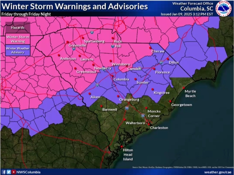
-A winter storm will affect much of South Carolina starting Friday and ending late Friday night or early Saturday.
The Upstate sees the earliest precipitation, perhaps starting by late morning.
-Precipitation spreads into the Central Savannah River Area (CSRA) and Midlands during the midday hours.
The Pee Dee sees precipitation start during the early afternoon.
-There is some uncertainty about the start time; there’s a chance it arrives a little earlier.
The Upstate will see the most significant impacts from the storm. Precipitation along I-85 will likely be mostly snow and sleet, with some freezing rain possible. The amount falling as snow will determine how much accumulates, but roads will become slippery and dangerous Friday and remain so into Saturday.
-An area including the southern Upstate, northern CSRA, northern Midlands, Catawba River Area, and upper Pee Dee will see mostly sleet and freezing rain, with only a little snow at the onset. If mostly freezing rain falls, there can be enough ice buildup to strain trees and power lines, while more sleet decreases the risk of ice buildup.
-Further south along the I-20 Corridor, marginal temperatures will limit the risk of slippery travel. However, roads, particularly elevated road surfaces, can become hazardous.
A period of sleet and freezing rain is likely in the lower Pee Dee Friday afternoon and evening before temperatures rise. There may be icy spots, mainly on bridges and overpasses.
-While parts of the inland Lowcountry and the Grand Strand may briefly see snow or sleet at the onset of the storm, these areas are unlikely to see any travel impacts, with mainly rain falling and temperatures above 32° during the storm.
-The rest of the Lowcountry will see only rain.
I’ll start with the latest snowfall maps from the National Weather Service. Below are maps of the forecast snowfall totals and the reasonable worst (best, if you’re a snow lover) case scenario for snow.
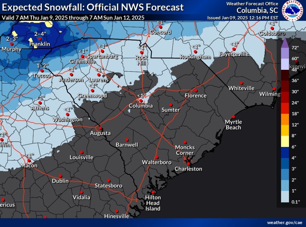
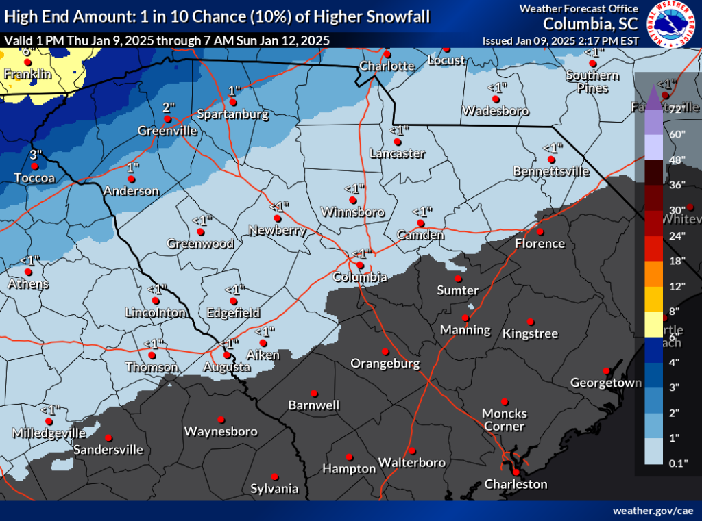
The trend in our computer model guidance since yesterday has been toward warmer temperatures aloft that result in less snow falling, with more sleet and freezing rain instead. We’ll see; a cold air damming situation such as we will see during the upcoming storm tends to be more robust than expected. This is one of several reasons there is much uncertainty about the storm less than 24 hours before the start time.
Speaking of ice, the NWS has a good map for that today as well:
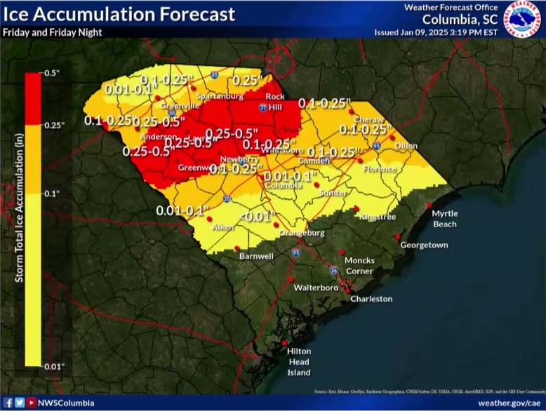
There is some uncertainty here as well. Much of the area that will get notable ice buildup (a tenth of an inch or more) will also see sleet and snow, with the snow and most of the sleet coming first. If it’s warmer aloft, and the layer of subfreezing air near the surface is more shallow than expected, then freezing rain will fall and ice buildup would be more like a quarter-inch. If so, tree damage and power outages would become more of a problem. However, as it stands now, tree and power line damage are not a huge concern.
The big concern is that the roads will be quite hazardous Friday afternoon and Saturday morning across the Upstate and adjacent areas. A layer of ice on top of snow or sleet, even if it’s thin, makes the roads extremely slick. Ten-year-old Frank wants to point out that this makes for fantastic sledding, though (oh, the stories he has to tell of the snow-to-sleet-to-freezing rain storm of ’82 in York County).
Further south, icy patches are possible down to I-20 and even a bit south. What falls in this area will mainly be rain, but there can be some snow and sleet as the event begins on Friday. The snow and sleet might even come down fairly hard for a half hour or so, whitening the grass and car tops, but it’s unlikely to cause travel problems other than reduced visibility. However, slippery spots are a concern Friday night with rain falling and temperatures close to 32°. Those traveling in this area during the storm will have to use great caution; unnecessary travel should be avoided.
Elsewhere in the Palmetto State, it will be all-rain or nearly all-rain with temperatures above 32°, with ordinary wet road conditions and perhaps lower visibility. That’s ugly weather, but manageable with caution, and the rain is needed.
It still looks quite cold over the weekend. Any leftover rain after daybreak on Saturday ends quickly, then sunshine returns. Sunday looks mainly sunny. The time it takes to melt the snow and ice will depend on how much snow and sleet falls. Roads likely remain hazardous through Sunday morning along and northwest of I-85, with some melting Sunday afternoon and maybe some leftover icy patches for Monday morning. Normalcy should return by Monday afternoon. Most of what’s on the ground Saturday morning farther southeast will melt that afternoon, leaving just an icy patch here and there for Sunday morning, then things should be back to normal Sunday afternoon.
That about covers it. Get what you need and want tonight or early Friday before the storm hits if you’re in the warned areas. If you’re not sure what you should have on hand, SCEMD’s SC Severe Winter Guide can help. I’ll leave you with one more picture, an infographic from the National Weather Service that helps to explain how the different winter precipitation types occur when there’s a layer of above-freezing air in place aloft.
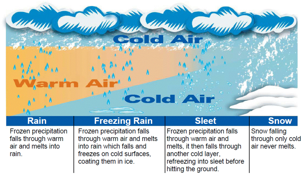
Imagine yourself floating about 2,500 feet above Georgetown and looking northwestward as you view that image. That will give you a good idea of what the situation over South Carolina will be like around 5 p.m. Friday.


