


By Frank Strait
Severe Weather Liaison
S.C. State Climate Office
S.C. Department of Natural Resources
As mentioned on Friday, a “not as hot front” moving into the Palmetto State is bringing us some badly needed rainfall from thunderstorms. Unfortunately, the storms have brought the rain at a “too much, too fast” pace in a few spots today and this is likely to occur again Monday near our coast.
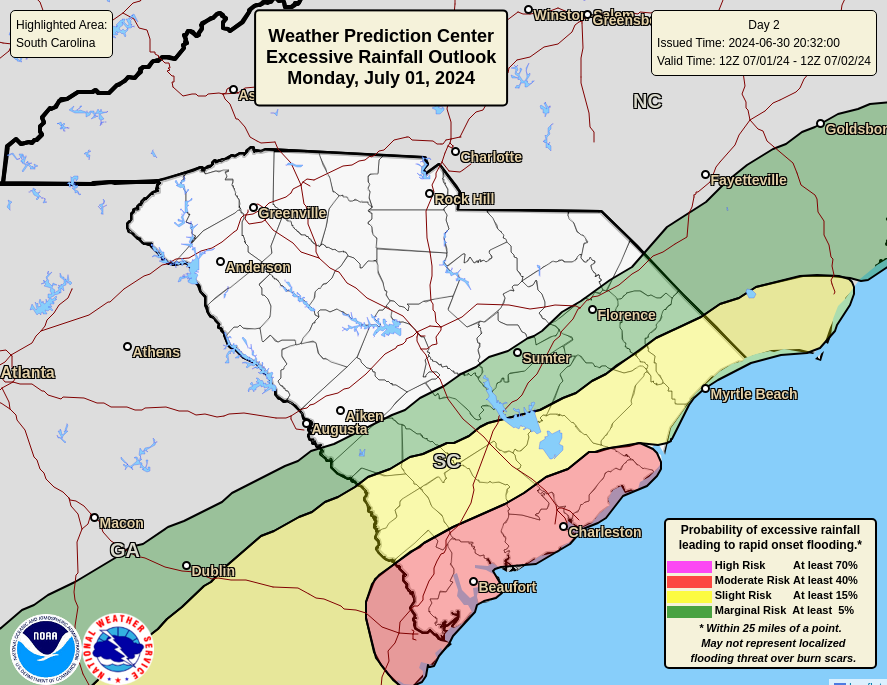
The front will slow to a crawl as it reaches our coastal areas Monday and slow-moving fronts lead to slow-moving thunderstorms. The slow drift of storms combined with a rich supply of moisture in the air mass over our region means that we could again see a frog-drowning amount of rainfall over a short time. As a result, the Weather Prediction Center (Because what else were we going to call them? Also, abbreviated WPC) has put our coastal areas into risk areas up to level 3 (out of 4) for excessive rainfall for Monday and Monday night.
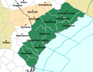
As a result, the National Weather Service has issued a Flood Watch for the Lowcountry counties (and some of their neighbors in Georgia).
from the National Weather Service.
The threat will be highest along the immediate coast because it might coincide with the afternoon high tide (around 5 p.m.) and we’ve all seen, and in some cases lived through, what extreme downpours can do at high tide along our coast. Hopefully, the storms will sidestep Charleston because prolonged downpours there at high tide during rush hour sounds like a recipe that only Satan would enjoy. Thankfully, we’re not in a period of high astronomical tides right now, though we will see some tidal flooding later this week as we approach Friday’s new moon.
Additional showers and thunderstorms will affect the Lowcountry on Tuesday as the front fizzles out, but should not be as intense or as widespread, so the flash flooding risk will be lower.
Elsewhere around the state, enjoy the drop in heat and humidity levels for Monday and Tuesday. We deserve it!
The game plan for Wednesday through next weekend remains the same. Heat and humidity will rebuild starting Wednesday and we’ll braise again by Friday. Friday through Sunday could all feature dangerous levels of heat and humidity. Temperatures likely peak in the 95-100° range with the usual I-20 hot spots potentially even hotter; heat index values might be up around 110. Cooling afternoon thunderstorms will mainly be absent on Independence Day through Saturday, and then chances for rain increase by Sunday.
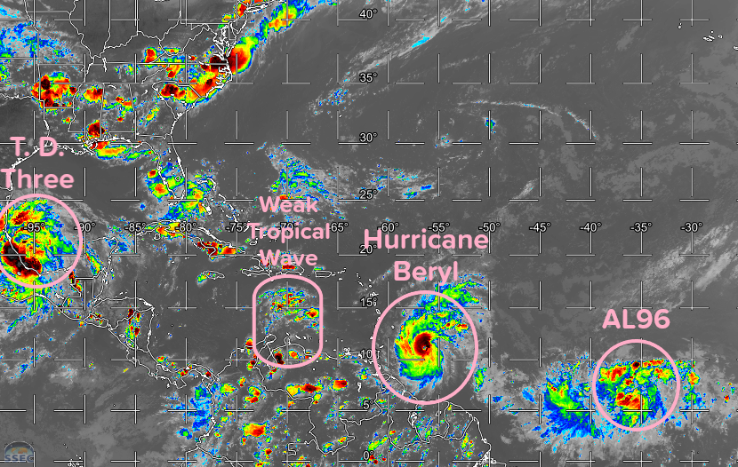
Finally, here are a few words about the tropics since the Atlantic is unusually active. Not only did we see development from the area of concern east of the Lesser Antilles, but it strengthened rapidly and is now a major hurricane named Beryl. It’s bearing down on the Windward Islands and it will be a devastating storm there. After that, a track toward Mexico and perhaps Texas looks most likely. Odds are near zero of it impacting South Carolina as a tropical cyclone, but maybe storm remnants wander this way eventually.
We also have a tropical depression (T. D. Three) in the Bay of Campeche that will move into Mexico overnight. It might strengthen into a tropical storm before it does; if so, the next name on this year’s list is Chris. It will not affect South Carolina.
Finally, another area of disturbed weather to watch is east of Beryl over the tropical Atlantic, Invest Area AL96. Following in Beryl’s footsteps, it won’t have quite the excellent set of conditions that allowed Beryl to go into Beast Mode as it drifts westward this week. However, there is a good chance (70% according to the National Hurricane Center) of becoming a tropical cyclone over the next week. Early signs are that it will take the low road through the Caribbean Sea as Beryl will, but it’s too early to promise it will never affect South Carolina.
Hopefully, no updates will be needed before Friday. Try to stay cool this week, y’all, and enjoy Independence Day!