

From The S.C. Climatology Office
By Frank Strait
Severe Weather Liaison
S.C. State Climate Office
Sunday (Aug. 4) Debby Update
Key Points:
Confidence has increased in a forecast for major impacts from Debby in South Carolina over the coming five days.
The main impact will be potentially historic rainfall amounts and flooding over parts of the country. Rainfall totals in the coming days over much of the Lowcountry could rival or even exceed those that occurred in early October 2015, resulting in widespread flooding, including areas that don’t usually flood.
Rainfall will also be intense across the Central Savannah River Area, Midlands, and Pee Dee, with the potential for flash flooding and river flooding.
While rainfall will be less in the Upstate, there will be a risk of isolated flash flooding.
Coastal flooding from storm surge and above-average astronomical tides will likely affect some or all our coast Tuesday through Thursday. These factors will exacerbate the flooding problems along our coast.
The confidence level is lower on the magnitude and timing of the wind risk. However, tropical storm-force winds appear likely over the coastal Lowcountry as early as pre-dawn on Tuesday. This may last for an extended period should the storm wander over the Atlantic. There remains a concern that Debby will drift far enough offshore that it intensifies and causes stronger winds along our coast.
Isolated tornadoes can occur over parts of the state Tuesday through Thursday. Coastal areas will see the greatest tornado risk.
Tropical storm Debby is intensifying as it moves northward over the hot waters of the eastern Gulf of Mexico and it is forecast by the National Hurricane Center (NHC) to be a hurricane by the time it makes landfall around daybreak Monday in Florida at Apalachee Bay, just southeast of Tallahassee. After that, it will take a right turn and slow down, with the center wandering toward southeastern Georgia and our Lowcountry.
The slow storm motion is the cause for what will be our biggest headache with Debby, which is the ridiculous amount of rain the storm is likely to bring us. The soggy setup is already getting started today thanks to a stationary front that’s sitting over our coastal areas. That front will retreat through Monday as it dissipates, but it will trigger showers and thunderstorms, a pre-game soaking that we do not need. Then on Monday night into Tuesday, rain from Debby will spread over our coastal areas, and we’ll see repeated bouts of heavy rainfall through at least Wednesday night as Debby wanders into South Carolina.
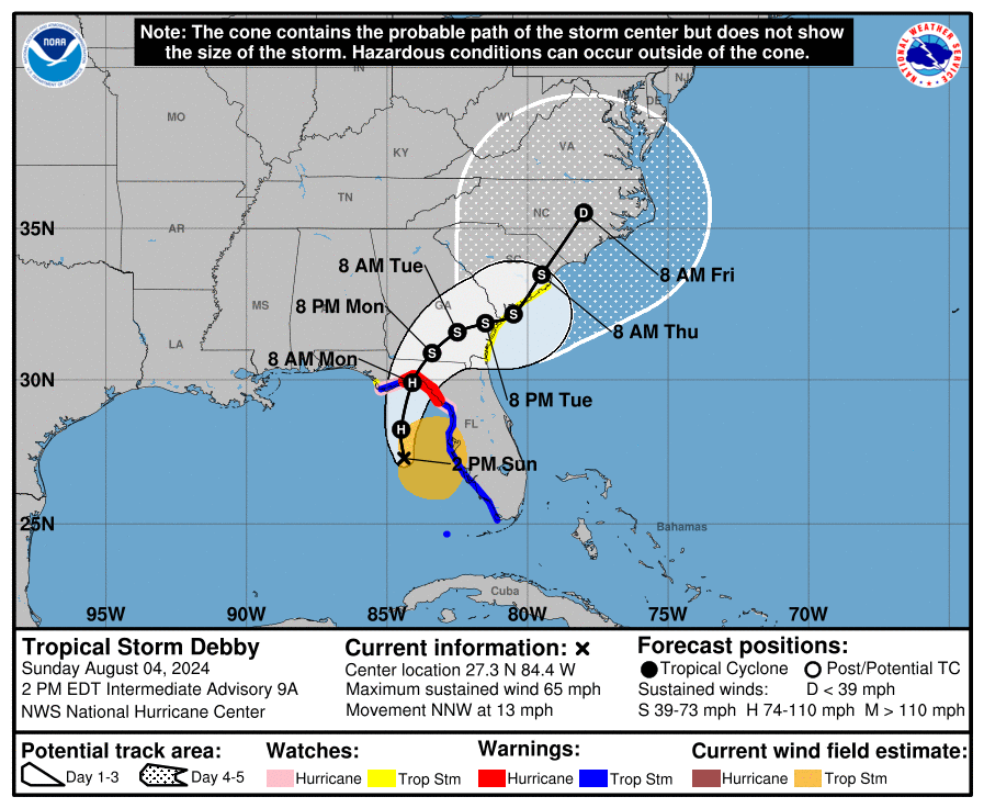
There remains considerable uncertainty about what will happen with Debby after Tuesday. Keep in mind that on NHC’s uncertainty cone graphic, the cone area refers to the zone where the center could track (based on a 67% historical accuracy of NHC forecasts). Possibilities include a more inland track, which would increase the rainfall threat farther inland, or a more offshore track that allows Debby to intensify over the Atlantic, increasing the wind damage and storm surge potential.
We’re hitting the threat of extreme rainfall and resulting flooding hard because we have the most confidence in this occurring and because of the extreme magnitude. I hate to raise the specter of October 2015 but the heavy rain threat appears to be that serious. The rainfall forecast from the National Weather Service (NWS) is quite grim.
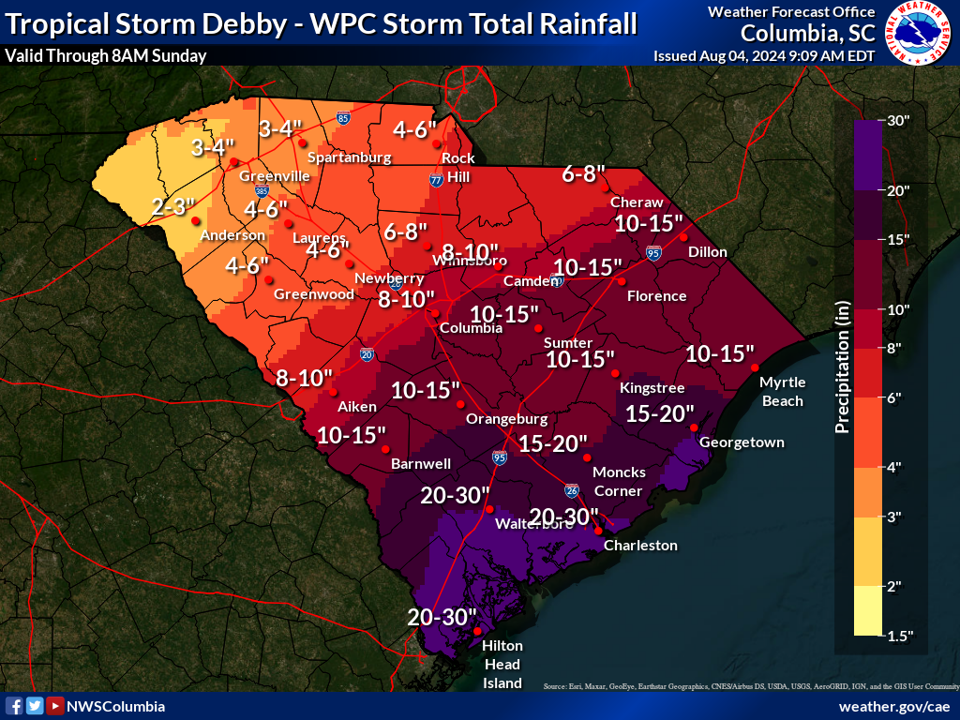
Should this forecast prove correct, some areas will see even more rainfall than during the 2015 event. For example, rainfall during the 2015 event (link to our Story Map that includes rainfall totals) was mostly under 10 inches over Colleton, Beaufort, Jasper, and Hampton Counties, while the current forecast is for seven-day rainfall totals many times that. For the rest of the Lowcountry, including the Charleston area, the forecast is for about the same amount of rain as in the 2015 event.
Further north in the Pee Dee region, the forecast is for less rain than in 2015 in the southern part and along the Grand Strand, but the upper part of the Pee Dee region is forecast to see much more rain. Most of the CSRA had it easy compared to the rest of the state in October 2015, while 6-12 inches of rain may fall there over the upcoming week. The forecast is for less rain in the Midlands than in 2015, but not much less. Across the eastern Upstate and Catawba River Area, the predicted rain is mostly the same, but less rain is forecast compared to 2015’s event over the western Upstate.
Extreme rainfall won’t be the only hazard we’ll face. Storm surge will be a risk as well. The forecast is for a 2-4 foot storm surge across the Lowcountry and 1-2 feet along the Grand Strand. This combined with relatively high astronomical tides will lead to flooding at high tide and will exacerbate the flooding we see from the extreme rain by slowing drainage into the ocean.
It seems strange having wind impacts third on the list for a tropical cyclone, but here we are. I think we have the least confidence in the forecast here. With the current forecast track, we’re likely to see tropical storm-force winds reach the Lowcountry Tuesday afternoon and continue through Wednesday. Then, Debby will shift over to the Pee Dee, with the winds mainly affecting the Grand Strand but could go further inland. No sustained tropical storm-force winds would occur along the I-20 Corridor if the NHC forecast track is correct, but there can be strong gusts that down a tree or power line here and there that far inland.
However, a track to the left could bring some of the stronger winds to the CSRA and Midlands, and a track to the right and over the ocean would result in Debby intensifying and packing stronger winds before the storm shifts back inland. If so, winds could reach the high end of the tropical storm range, perhaps even hurricane strength. It will be another day or even two before we know with certainty how much wind risk we have, and stronger winds are the curve ball that Debby might throw at us.
With any tropical cyclone moving through, there is a tornado risk to consider. This will be more of a concern along the coast than elsewhere, but this risk will depend on Debby’s track, which is uncertain past Tuesday. Most of the Lowcountry should be alert for tornado warnings starting Tuesday into Tuesday night, and more of the state may be at risk Wednesday into Thursday.
So, time to prepare is ticking away. Do you know where your disaster kits are, and how well-stocked they are? You might need them this week. Keep in mind that even if your home doesn’t flood, roads leading out of your neighborhood or to and from the grocery store might be flooded. Make sure you have what you need. More storm prep details are always available at hurricane.sc. And please turn around when you encounter flood waters so you don’t drown.
As much as I’d like to say there’s nothing else out of the Atlantic to watch, there is one feature to track east of the Windward Islands. NHC gives it a 20 percent chance to develop over the next seven days. Some computer models show it bringing an unwanted fresh wave of rain in a week or so. Let’s hope and pray it doesn’t.


