By Frank Strait
Severe Weather Liaison
S.C. State Climate Office
Key Points:
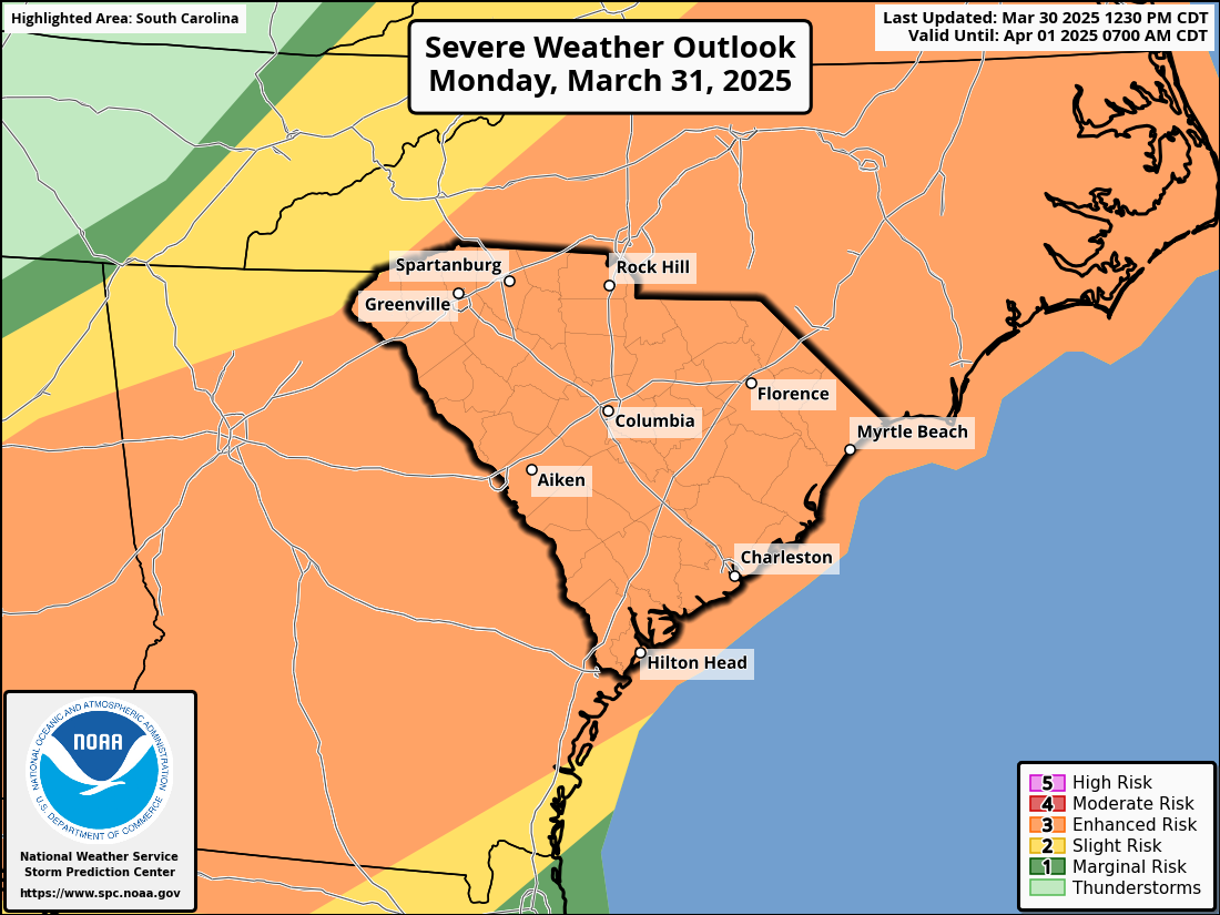
On Monday, we have a level 3 of 5 risk for severe storms across South Carolina.
The primary concern is damaging wind, which may be more widespread than we usually see with severe storms.
A few isolated tornadoes can occur with the storms.
A few spots may also see damaging hail.
Review your severe weather action plan before bed tonight or first thing Monday morning so that you and your family know what to do when storms affect your area.
Good evening. I need a quick word with you before bed, or at least first thing Monday morning when you rise to shine.
If you haven’t already, I need you to do me a favor. Please ensure that you and your family have a severe weather action plan. Y’all need to know what to do when a severe thunderstorm or tornado warning comes out for your area. You will find a wealth of severe weather safety tips from the National Weather Service, Ready.gov, and SCEMD, so I won’t go over every detail here except to say that it’s essential to decide in advance what’s best for your situation because you might not have time for that decision when severe weather hits Monday afternoon or evening.
You may have heard already from your friendly neighborhood meteorologist that there’s a risk for severe weather on Monday. All three severe thunderstorm threats will be in play: damaging wind, large hail, and tornadoes. The Storm Prediction Center has virtually the whole state in a level 3 of 5 “enhanced” risk area for Monday (if you want to split hairs and hold a magnifying glass up to Oconee County, there’s only a square mile or two at level 2). I’ve mentioned this before, and I’ll mention it again: Level 3 is where things start to get really concerning.
You don’t have to lose sleep over it tonight because the event will start around midday Monday, with the storms moving offshore by late evening. So, there’s no concern for extra-scary middle-of-the-night tornadoes this time around. However, the middle-of-the-afternoon tornadoes that might happen on Monday are plenty scary enough.
Fortunately, the tornado risk is playing second fiddle on Monday. The primary concern is for damaging straight-line winds, which may be widespread with a line of thunderstorms that crosses the state. The hail risk is our third-stringer for Monday; damaging hail will be isolated.
With the primary ‘enhancement’ to the thunderstorms on Monday being the damaging wind risk, you’ll want to pay closer attention than usual to any severe thunderstorm warning you might get. Often, only a tiny part of the warned area gets damaging wind or hail with a severe storm, but Monday’s storms will be capable of causing more widespread high wind. So, take those warnings seriously, and be ready to move indoors fast if you get one.
The rain we had today and will see from the storms on Monday is welcome and badly needed, but it will only put a small dent in our drought. Unfortunately, our opportunities for rain later this week appear to be falling through, with a hot high-pressure area deflecting weather systems to the north instead. Yes, I used the word “hot.” After a lovely Tuesday, unseasonably warm air will push in. Some areas could get a shower or two on Wednesday, and then Thursday through Saturday will feel like June. Hotter spots may see the first 90° readings of the year on Friday and Saturday. We might finally get a cold front to cool us off by Sunday, but that may not get to us until Monday.
Early signs are that we’ll see a big turnaround behind that front. It’s like Old Man Winter is angry about being evicted and will throw a vengeful punch at us early next week. Our reversal of fortune will aggravate sensitive sinuses (as if this year’s episode of The Pollening wasn’t enough) and may even send the colder spots of the Upstate down to near 32° one or two mornings. More on that later in the week when there is more confidence in the details.


