From the SC Climatology Office
Since last Friday, we saw our first tropical cyclone of the year, Tropical Storm Alberto, form over the Gulf of Mexico. As expected, it tracked west into Mexico and caused flooding from storm surge and extreme rainfall in Texas, with no impacts to South Carolina.
Today, we are tracking two features for possible tropical development. One is close to home, and the other is over Central America. Let’s begin with the one that will affect South Carolina. It’s Invest Area 92L, centered east of Fernandina Beach, Florida. It’s heading slightly south of due west and will come ashore close to Jacksonville this afternoon. It has been embedded in a dry and stable air mass, which kept it from generating enough thunderstorm activity to become a tropical cyclone. It still has a chance to become a tropical cyclone before it reaches land as it moves over warmer-than-usual water. It most likely would be a tropical depression if it did, but if it reaches tropical storm strength, the next name on this year’s list is Beryl.
Moisture from the storm’s periphery will push into our Coastal Plain this afternoon and tonight in the form of gusty showers and a thunderstorm here and there. After moving ashore, it will drift northward through southeastern Georgia tonight and Saturday, then across South Carolina Saturday night into Sunday. The impacts here in South Carolina will mostly be positive because it’s been dry for weeks across our Coastal Plain; the rain will be welcome. I would like to see this feature overperform with its rain production, as parts of the Coastal Plain have been bone-dry for 6-8 weeks. There won’t be any widespread damaging wind in South Carolina, no noteworthy storm surge, and a near-zero severe storm and tornado risk.
The other feature we’re watching is like the one that spawned Tropical Storm Alberto. It’s a Central American Gyre (a large but weak low-pressure area over Central America occasionally seen in May and June, then again in fall) swirling over southern Mexico, Guatemala, and Belize. I think we will see a repeat of what happened with Alberto, with this feature wandering over the southwestern Gulf of Mexico for a while before moving into Mexico next week. The National Hurricane Center gives it a 60 percent chance of becoming a tropical cyclone. On this track, it won’t have any effect on South Carolina. Chris is the third name on this year’s list, should the storm in our neighborhood claim Beryl before moving over land.
Elsewhere in the Atlantic, we’re watching tropical waves drift westward through the tropical Atlantic and Caribbean Sea; they are south of Puerto Rico along 65° west longitude, east of the Lesser Antilles along 55° west, midstream in the Atlantic along 40° west and south of Cabo Verde along 23° west. None of these show signs of further development, and they will track through unfavorable areas over the next few days. However, we may see another Central American Gyre form later next week, which may combine with one or more of these tropical waves to produce a tropical cyclone later next week or next weekend.
Consider 92L to be a warning shot. This hurricane season is likely to be active, so our odds of being impacted by a tropical storm or hurricane are higher than usual. So, it’s critical that you have your plan in place and your disaster kit fully stocked. If you need help, SCEMD’s hurricane.sc website is the place to go.
Aside from the influence of the tropical disturbance approaching Florida, our stretch of tranquil early summer will continue through the first part of next week. Spotty showers and thunderstorms, mainly during the afternoon and evening, will primarily affect the Coastal Plain, Midlands, and Central Savannah River Area over the weekend. The influx of moisture keeps the heat from getting out of hand, with temperatures reaching the low to middle 90s for highs on Saturday and Sunday.
A weak cold front will limp in on Monday, triggering stray afternoon and evening thunderstorms. The front won’t bring any cooling; it will just fizzle out as hot air moves in from the Plains and Midwest. So, the heat will increase on Monday, with highs mainly in the middle to upper 90s across the state.
After that, we will bake for a while as persistent northwesterly flow brings us more hot air from the nation’s midsection. Tuesday and Wednesday will feature highs in the 95-100° range, with only our coastal areas and the sliver of mountains in the Upstate significantly cooler. Humidity will remain relatively low during this time, so we will at least have that going for us, but that also means we won’t see any cooling afternoon thunderstorms.
Another cold front will move our way after that, but computer models disagree about when it will arrive. We may cool off with thunderstorms on Thursday if the front moves in fast enough, but we will remain in the oven instead if the front is slower. I’m more confident in saying that we’ll cool down by Friday. With intense heat present ahead of the front and humidity increasing as it arrives, there is a chance we’ll see severe storms when the front moves through, especially if it reaches us during peak daytime heating on either Wednesday or Thursday.
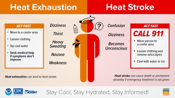
South Carolina is known for summertime heat, and it’s no shock to the system for us to have a heat wave in June. Most of us have plenty of practice with dealing with the heat. On the other hand, we have a lot of newcomers, and complacency about the heat is where our natives and long-timers can get into trouble. So, be sure to review extreme heat safety rules. Like with hurricanes, our friends at SCEMD have a collection of safety tips for extreme heat that you can find on their website.


