By Frank Strait
Severe Weather Liaison
S.C. State Climate Office
S.C. Department of Natural Resources
Let’s stop, collaborate, and listen to the tropical discussion.
We have no brand new inventions in the tropical Atlantic today, though a couple of tropical waves will try their best over the next week.
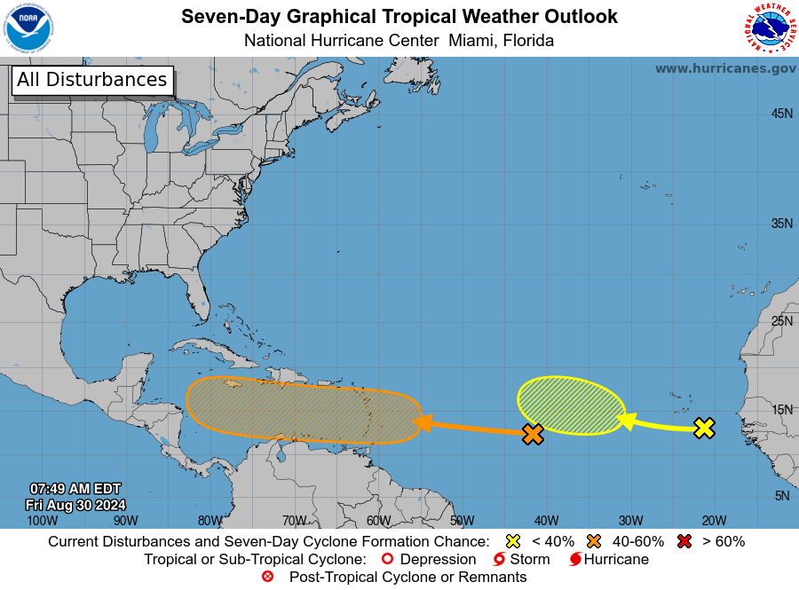
There are currently three tropical waves to track over the Atlantic Basin. One is near 80° west over the western Caribbean Sea, which is helping to spawn thunderstorms around Cuba, but this activity is disorganized, and further development is unlikely.
The other two waves are between the Lesser Antilles and Africa. Forecasters at the National Hurricane Center (NHC) have their eyes on both of them and have slapped Xs on them in their outlook from early this morning.
Our first spinny critter is centered near 13° north and 43° west and is slowly drifting toward the Lesser Antilles. It’s in an area that seems good for development because the water is warm and vertical wind shear is low. However, the mean ol’ Madden-Julian Oscillation (more on the MJO if you’re new here) is interfering by causing air to subside over this part of the world, and that sinking air is slowing development. Over time, as this feature drifts farther west toward the islands, it will encounter increasingly favorable conditions from an MJO standpoint. So, this feature has a chance to develop once it reaches the islands around Tuesday, but don’t be surprised if the development process takes longer, if it develops at all. NHC gives this one a 40% chance to become a tropical cyclone, which means there’s a 60% chance that it doesn’t and remains mostly harmless as it drifts into Central America later next week. On the other hand, should this feature get its act together over the Caribbean, a strong upper trough over the eastern part of the country next week would likely pull it northward out of the western Caribbean and possibly our way. So, we’ll watch this thing closely.
The other tropical wave out by Cabo Verde has a nice spin, but it doesn’t have much else going for it. Some dry and dusty Saharan air is entangled with it, and there’s that MJO-related sinking air that it will have to fight with. Some computer models show it developing next week as it trudges across the tropical Atlantic, but those that do think it will turn north long before it could impact us directly. We’ll keep an eye on it because those fish-mixing storms still affect us by causing hazardous seas and surf along our coast if they get strong enough. NHC gives it a 20% chance to become a tropical cyclone over the next week.
It’s worth mentioning that another tropical wave is taking shape over Africa, with thunderstorms swirling over Togo, Benin, and Nigeria. However, the recent pattern has been for these nice-looking tropical waves to go kaput once they reach the eastern Atlantic. We’ll see if this one fares any better next week.
Also worth mentioning is that we’ll see another good-quality cold front reach us next week and become stationary over the Gulf Coast and Southeast Coast. Occasionally, we see a sneaky tropical development along them.
September is about to start; that’s prime time for tropical cyclone activity, and you should be ready for it. Sure, we feel like we have already paid our dues for this season with Debby, but the atmosphere doesn’t care about our feelings. So stay ready, and if you need guidance, SCEMD has hurricane.sc to help.
Yes, I used the term ‘cold front’ above. We’ll eagerly await its arrival on Monday, but in the meantime, we will stay in a hot and swampy air mass. So, we will continue to see highs mainly in the 90s around the Palmetto State through Sunday. Routine summer afternoon and evening thunderstorms will mostly affect the Upstate during this time; remember that any storm can cause locally damaging winds.
The front will bring us more widespread showers and thunderstorms on Monday, which should hold our high temperatures down to the 80s over most of the state. Don’t be surprised to see a severe storm or two around on Monday. Cooler and drier air will push into most of the state from the north on Tuesday into Wednesday, but the front will become stationary near our coast, and that will mean a chance for showers and perhaps a thunderstorm in that area those days, especially in the Lowcountry.
Later in the week (I’m not sure about the timing yet, so I’ll leave it at that), an upper-level disturbance will push through the southeastern states and generate a wave of rain. It might bring a soaking, and we could use it because there hasn’t been much rain since Debby. A couple of weeks of dry weather after that storm was great, but we’re at the point where we need some rain again.
WEATHER REPORT: Atlantic Tropics Perking Up?