By Frank Strait
Severe Weather Liaison
S.C. State Climate Office
S.C. Department of Natural Resources
It looks like the weather through Christmas Day is going to follow the general outline I gave y’all a week ago:
A nearly moisture-starved cold front will cross South Carolina this afternoon and evening.
-Stray shower activity with the front will stay near the North Carolina line.
-It’s cool, so there can be small hail or graupel with any shower.
-It will turn windy for several hours as the front moves through, with peak gusts of 30-35 mph for most places.
This weekend and Monday will be rather cold, though mainly sunny each day.
Highs will only be in the upper 40s north to middle 50s south on Saturday.
Sunday should be the coldest day with highs in the low 40s Upstate to near 50 in the Lowcountry. This may be slightly optimistic; maybe it’s a couple of degrees colder.
Monday’s highs will range from the middle 40s north to mid-50s south.
Saturday begins with most of the state at or below freezing, and Sunday through Tuesday all begin well below freezing. Monday looks the coldest, with some areas near the North Carolina line dipping to the teens. That’s bitter, but no worse than what we have seen season-to-date.
Moisture and milder air will return Christmas Eve into Christmas Day.
The onset timing is uncertain. It will cloud up Monday night into Tuesday and some light rain may break out as early as Tuesday afternoon. Temperatures moderate but remain slightly below average.
Christmas Day will likely be gray with some or all of South Carolina seeing rain. Some computer models keep the Pee Dee dry through the day with rain beginning at night.
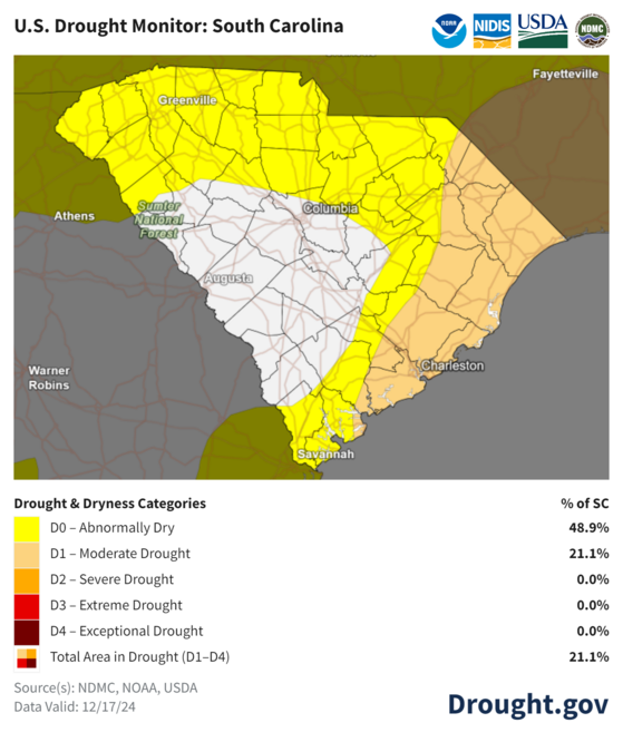
Next Thursday and Friday look wet. Don’t complain; we need the rain. We may even stay in a prolonged wet pattern next weekend and the first part of the following week. Let it rain. Much of the state is experiencing drought conditions.

The latest U. S. Drought Monitor for South Carolina from Tuesday shows much of South Carolina to be dry, with a moderate drought over parts of the Pee Dee and Lowcountry.
And finally, those hoping for just one winter storm this year (since we have been shut out for the last two winters) will be disappointed to hear that we’re likely to see above-average temperatures for the end of December and the first few days of January. However, colder air could return again around January 5, so don’t lose all hope just yet.
Merry Christmas, y’all. I hope everyone gets to enjoy quiet family time next week, or noisy and chaotic family time, if that’s your thing … you do you! See y’all next Friday.
WEATHER OUTLOOK-Cold Spell Commencing; Milder and Damp For Christmas


