By Frank Strait
Severe Weather Liaison
S.C. State Climate Office
I hope your Christmas went as well as mine did! Time with grandchildren and delicious smoked meats were my highlights. As for the weather, I hope that Mele Kalikimaka was in your rotation of Christmas songs, since the record-tying high in Columbia yesterday matched the high in Hilo. For most of the state, it was either a tie for the warmest or a close second-warmest Christmas on record.
Today we’re knocking the temperatures down over most of the state thanks to a backdoor front that moved in early this morning (so called because it moves in from the northeast instead of from the west, as we see 90 percent of the time). Most of the Lowcountry and Central Savannah River Area will remain in the warm air and see 70s again this afternoon, but clouds and cooler air will keep it in the 60s and even the upper 50s across areas to the north and east. We’ll see no needed rain from this front.
The front will retreat tonight, and the unseasonable warmth will return for Saturday. Sunshine will be prevalent with temperatures shooting back up to the mid- to upper-70s. 80 is possible in the warmest spots.
On Saturday night, another backdoor front will muscle its way in from the northeast and beat back the warmth again. Sunday’s weather could resemble today’s, though there is some uncertainty about where the front will lose momentum and stall. Fresh computer model output from this morning indicates the front will push all the way across the Savannah River. If that’s the case, we’re going to stay in the 40s and low 50s across the north, with middle 50s to low 60s in the south. Earlier computer models show the front stalling further to the northeast, allowing areas southwest of I-26 to reach the 70s again. I can say with more confidence that the front won’t produce any significant rain, nothing more than a stray sprinkle.
The pattern repeats Sunday night into Monday; the backdoor front retreats, and warmth returns as a more typical cold front moves in from the west. Exact timing is uncertain, but the front will arrive in the Upstate at midday Monday or early afternoon and along the coast after nightfall. So, we’ll see it get toasty again on Monday, with most of the state reaching the 70s. Middle to upper 70s will be likely along and south of I-20. Areas along and northwest of I-85 may only get to the 60s as cooler air arrives in the afternoon.
There can be a shower or two as this front moves through, but no part of the Palmetto State will see any substantial rain, which is disappointing.
Behind that front, we’ll snap back to reality (ope, there goes gravity) as polar air blasts in on a gusty northwesterly wind, and we’ll see a dramatic drop in temperatures. The difference between Monday’s highs and Tuesday morning’s lows will be about 40 degrees, with the Upstate and vicinity expected to see temperatures below freezing. Temperatures will only recover to the upper 40s and lower 50s on Tuesday afternoon.
The rest of next week brings us a slow warmup to average temperatures (highs in the 50s) while we remain under an area of high pressure. We’re likely to be dry and seasonably chilly for New Year’s reveling.
Over the last week, drought conditions expanded across the north and held on over the Lowcountry and southern Central Savannah River Area.
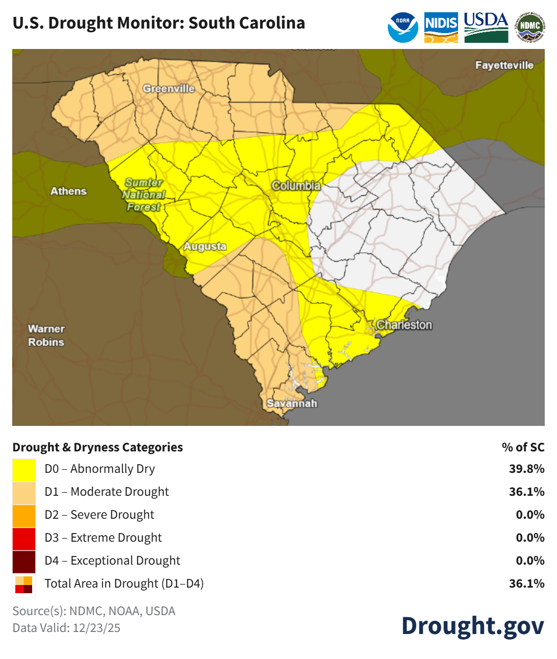
The drought is likely to worsen over the next week, as we have no good prospects for rain. The following week will feature a couple of opportunities for needed rain, but it’s too early to say if we’ll see anything substantial.