By Frank Strait
Severe Weather Liaison
S.C. State Climate Office
S.C. Department of Natural Resources
Key Points:
* The forecast looks dry statewide through this weekend, though we continue to monitor the details with a disturbance that will pass near our coast on Thursday.
* Melting of the snow and ice on the roads will be slow through Friday as it remains cold.
* Along the I-20 Corridor, watch for icy areas tonight and Thursday morning if you must travel. Further south, all but * the main roads will remain icy until Thursday afternoon.
* Another refreeze is likely for the Coastal Plain Thursday night, with secondary and back roads becoming icy into Friday morning.
* Icy patches are possible again Friday night and early Saturday in areas with the heaviest snow.
Our storm is over, and the sun is out again!
However, the effects remain. The 3-6 inches of snow and sleet expected late yesterday fell over the Coastal Plain. The heaviest snow accumulation I have seen is 6.8 inches north of Conway in Horry County.
Even areas that didn’t get a lot of snow can still have slick roads. U. S. 321 in Lexington County was a veritable sheet of ice this morning as I drove to the office around 10 a.m.; there were three wrecks along the three-mile segment I traveled.
The sun and slightly above-freezing temperatures will start the melting process this afternoon but don’t expect miracles. Areas along and south of I-20 will have lingering water, slush, or ice on the roads at nightfall, which will freeze up again tonight as temperatures fall far below freezing.
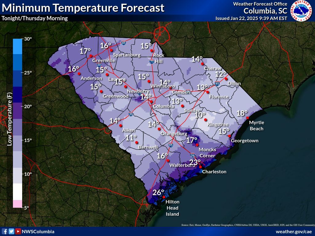
The interstates and most other major roads should be clear by nightfall, but other roads will certainly not be clear. So, travel will remain hazardous through Thursday morning. You’ll have to be careful even on treated roads. Road salt and brine treatments become less effective when it’s below 20°, especially when it reaches low teens. Even treated roads might get icy.
We continue to monitor the situation with a disturbance that will pass just offshore on Thursday. It still looks like precipitation will stay offshore, but it will be nearby. There would be concern for some light freezing rain if it reached our coast, but I’m cautiously optimistic that it will remain dry. However, with many clouds around and highs mostly 35-40 on Thursday, melting will be slow again. We should be able to clear the roads in the I-20 Corridor, but this won’t happen in areas farther south in the Coastal Plain. Main roads may be clear by the end of the day, but back roads likely won’t. So, plan on icy back roads and neighborhood streets again on Friday morning.
Friday is looking warmer, with highs in the low to middle 40s. An upper-level trough will be moving through, but it will be moisture-starved and only bring us patchy clouds. So, sunshine and milder temperatures will melt away most of the lingering ice on the roads around the Coastal Plain. However, some shady areas might still have lingering puddles or slush at the end of the day, so those out on the back roads Friday night and early Saturday must be careful.
The weekend looks dry, with highs in the middle to high 40s on Saturday and then lower to middle 50s on Sunday. We’ll have a chance for rain on Monday.
I’ll be back on Friday to tell you more about the chance for rain on Monday and the warmer weather pattern shaping up for next week.