
By Frank Strait
Severe Weather Liaison
S.C. State Climate Office
S.C. Department of Natural Resources
Key Points:
-Wednesday and Wednesday night will bring rain to most of South Carolina, but some northern areas will see snow, sleet, and freezing rain for a time.
-Light snow will fall along and north of I-85 for much of Wednesday; York County will also see some light snow. However, temperatures will remain above freezing, so accumulations will stay under an inch.
-Rain Wednesday afternoon over the Pee Dee will turn to freezing rain in some areas Wednesday evening as temperatures drop to or below freezing. No significant ice buildup will occur, but elevated roads may become icy.
-The northern and eastern Midlands will see primarily rain, but some snow may mix in, and there may be an hour or two of -freezing rain on Wednesday evening.
-The rest of the state will see only rain with temperatures above freezing.
-Temperatures will fall below freezing over much of the state Wednesday night, so lingering water or slush on the roads can freeze up and lead to icy patches. The concern for icy patches is greater north of I-20 than areas farther south.
-A cold front will move through Thursday morning and midday, which will cause some flurries, mainly north of I-20. A period of steadier snow is possible near the NC state line; a dusting is possible in some areas.
Friday will be frigid, with morning lows in the teens and 20s and highs only in the 30s and 40s.
Not much has changed with our 1-2 punch of minor winter weather events coming Wednesday into Thursday. The storm looks like mostly a nuisance, but there will be some travel impacts to deal with.
The storm is now crossing the nation’s midsection, with some high cloudiness streaming into South Carolina ahead of the storm this afternoon.
Precipitation will spread over South Carolina starting mid-morning Wednesday along the Savannah River and reaching the Grand Strand by early afternoon. It will be light most of the time. For most of the state, this will be a cold rain. However, snow will fall along and north of I-85, and most of York County and parts of the Pee Dee will get some freezing rain Wednesday evening.
It still looks like a cold front moving through Thursday morning can squeeze out some light snow over parts of the state. The snow will be very light where it occurs, and only a dusting will occur where there is any accumulation.
I’ll do a regional breakdown again today.
Upstate and Catawba regions:
As we often see with winter storms, I-85 will be the landmark dividing areas that see mostly snow from places that do not. Snow will fall on Wednesday along and north of that highway, mainly rain to the south. However, surface temperatures will remain slightly above freezing. Also, the snow is coming during the day, and it’s the third week of February, so the increasing sun angle matters. It has to snow hard to get an accumulation during daylight hours this time of year (and it gets a bit harder with every passing day). So, while snow will be in the air, not much will accumulate. An inch or two worth of snow may fall along and north of I-85 and over to the Rock Hill area, but it will be a struggle to get it to accumulate unless it comes down heavier than we expect. Shady areas might get a half inch or so of slush to stick on the grass, car tops, and elevated road surfaces. However, roads will mainly be wet during the day.
Temperatures will drop below freezing quickly Wednesday evening, so any lingering water or slush on the roads will freeze up, so there can be icy patches not long after dark. Elevated roads will be the main area of concern, but after midnight, all roads could have icy patches. You’ll have to exercise great caution if you’re out.
Also, over in Lancaster and perhaps Chester County, areas seeing rain instead of snow may see temperatures drop below freezing before the rain ends, resulting in a couple of hours of freezing rain and drizzle. There won’t be enough freezing rain for significant ice buildup, but some elevated roads could become icy.
Thursday morning’s cold front will generate some flurries in this area. Some areas will see a dusting. Computer models agree that the best chance for a small accumulation from a period of steadier snow will be in the Catawba region (York, Chester, and Lancaster Counties). Even a thin coating of snow can make the roads slick, and the snow may conceal icy patches from Wednesday evening’s freeze-up, so exercise great caution if you have to be out Thursday morning.
Pee Dee:
Temperatures will be above freezing as the rain arrives Wednesday afternoon. The trouble comes later in the afternoon into the evening as temperatures drop. We continue to see differences among the computer models in terms of the extent of the potential for ice buildup. Some show freezing rain over the entire Pee Dee, even the Grand Strand, while others show mainly rain with temperatures above freezing. What’s likely is that the interior of the Pee Dee will see a few hours of freezing rain (maybe some sleet mixes along the state line) before the precipitation ends. So, there won’t be any significant ice buildup, but some elevated road surfaces could get icy.
Temperatures fall below freezing across the region Wednesday night, so any lingering water on the roads will freeze up. You’ll have to be on the lookout for frozen puddles early Thursday; an icy patch here and there is possible.
Finally, Thursday morning’s cold front will squeeze out a few stray flurries, mainly over the upper Pee Dee. However, accumulations are unlikely, except for Marlboro and Dillon counties, where some spots may see a dusting.

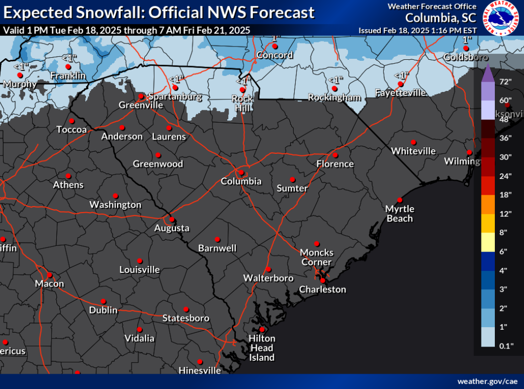
The National Weather Service forecast for ice buildup Wednesday and Wednesday night.
Midlands:
Wednesday and Wednesday evening mainly bring rain here. The northern Midlands might see some wet snowflakes mix in, and it may drop below freezing for the last hour or two of rain over the northern and eastern Midlands. A bit of freezing rain can go a long way toward making roads slick. Use caution if you have to be out Wednesday evening.
Temperatures will drop below freezing Wednesday night; even if no freezing rain occurs, lingering water on the roads might freeze. So, be alert for icy patches if you’re out later Wednesday night or early Thursday.
Thursday morning’s cold front may cause a snow flurry or two, mainly north of I-20, but accumulations are unlikely.
Central Savannah River Area and Lowcountry:
Sorry, CSRA snow lovers, it now looks like you’ll see rain along with the Lowcountry. There’s a chance some snow mixes with the rain in McCormick and Edgefield Counties, but don’t get your hopes up. Also, don’t expect to see any flurries with the front Thursday morning, but there’s a slight chance for it north of I-20.
Most areas away from the coast will drop to or a little below freezing Wednesday night, but not until late, after most places dry out. Stay alert for icy patches on Thursday morning, but I don’t think it will be much of a problem.
Post-storm Weather:
It still looks very cold for the end of the week as we get a taste of the arctic air that has sent temperatures down to around -40°F in the coldest parts of the northern Plains over the last few days. We won’t see subzero readings, but Friday morning’s lows will be in the teens and 20s. Temperatures will gradually moderate over the weekend. The next chance for any precipitation comes Sunday night or Monday, though today’s computer models keep that weather system to our south (I suspect the storm tracks further north than the models indicate; they’re known to track storms too far south through this part of the country, but maybe the models are right this time).
Traveler’s Advisory:
Areas to our north and northwest remain on track for a significant snowstorm, with a band of 3-6 inches and locally higher amounts stretching from the central Plains states to the Delmarva Peninsula through Friday morning. Be prepared for dangerously slippery roads if you must travel through this area through Thursday.