


By Frank Strait
Severe Weather Liaison
S.C. State Climate Office
The forecast for the next couple of days has changed enough to warrant an update today. It’s not a big change; we remain at risk for a potentially significant severe thunderstorm and tornado outbreak on Monday.
The main change is to include a low-end risk of severe storms on Sunday. A weak cold front is moving into South Carolina this afternoon, stalling tonight before retreating northward on Sunday. As it does, humidity levels will increase, and it will turn humid enough for the front to trigger spotty afternoon and evening showers or thunderstorms. I mentioned that on Friday, but now it looks as though any thunderstorm that develops could be severe, with isolated damaging winds and perhaps even an isolated weak tornado or two. So the outlook from the Storm Prediction Center (SPC) for Sunday has the whole state in a level 1 of 5 ‘marginal’ risk area.

The inclusion of the western Upstate in a level 2 of 5 ‘slight’ risk area is to cover for the potential for the main wave of severe weather ahead of an approaching cold front to reach that area before 8 a.m. Monday. These outlooks run from 8 a.m. to 8 a.m. (7 a.m. to 7 a.m. when we’re on Standard Time).
The outlook for Monday has changed little; we’re just a day closer, so SPC’s outlook is more detailed and looks like something you’re more familiar with.
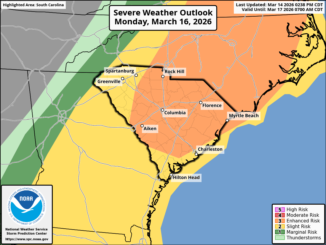
We remain on track for an outbreak of severe thunderstorms on Monday, capable of causing widespread damaging wind, large hail, and tornadoes. It still looks like the timing will be early in the day over the Upstate, possibly even before daybreak in the far west, through midday. The rest of the state will see the storms hit from midday through early evening. The worst of the severe storms is likely to occur over the Central Savannah River Area and the I-77 Corridor and eastward to the coast. Like with that 30% area on the Day 4 Outlook from SPC I showed you yesterday, the level 3 of 5 ‘enhanced’ risk area appearing on a Day 3 outlook is a ‘we mean business’ signal from SPC forecasters.
For what it’s worth, it will be quite windy on Monday even outside of thunderstorms, with peak gusts in the 40-45 mph range. It will be a tough day to travel on our state’s highways, and the same will apply to neighboring states. Secure any loose items in your yard on Sunday.
We’re a day closer, and I hope you’ve had a chance to review or create a plan to protect yourself and your family ahead of Monday’s potential severe storm outbreak. If not, you’ll find severe storm safety tips on the National Weather Service’s website. Good information is available from SCEMD as well.
As I mentioned on Friday, unseasonably cold air will blast into South Carolina behind Monday’s front, leading to at least one morning of freezing temperatures for most of the state, with the northern part of the state seeing two or maybe even three consecutive days of lows at or below freezing. A hard freeze appears likely over the Upstate and vicinity on Wednesday morning with lows in the lower to middle 20s. That will be the worst morning of the cold wave.
Plan to protect any tender plants you might have out each morning Tuesday through Thursday, or bring them indoors if you can.
I’ll have another update later Sunday or Sunday evening.