
By Frank Strait
Severe Weather Liaison
S.C. State Climate Office
With Hurricane Melissa on the way out this morning, the tropics are turning tranquil. Once it becomes an extratropical storm later today, we’ll have no storms to track in the Atlantic Basin.
Melissa turned out to be a disaster for much of Jamaica, hitting the island as not just a Category 5 hurricane but one of the strongest Atlantic hurricanes on record. A post-season study of the data collected during the storm and a survey of its damage will determine Melissa’s proper place in history. With what we know now, Melissa stands as the third-strongest hurricane in the Atlantic Basin’s history in terms of lowest barometric pressure (26.34 inches of mercury, behind Wilma of 2005 and Gilbert of 1988, tied with the Labor Day Hurricane of 1935), and second-strongest in terms of strongest winds (185 mph, behind Allen of 1980 at 190 mph and tied with four other hurricanes).
I encourage you to find and contribute to a charity helping those affected if you have the means.
Melissa is still a hurricane, but won’t be for much longer. It will clip parts of Atlantic Canada on its way to the northern North Atlantic. As an extratropical entity, it will approach Europe around the middle of next week.
Elsewhere in the Atlantic, there is only one feature of interest, which is a tropical wave along 59° west, approaching the Lesser Antilles. It will continue tracking westward in the coming days, eventually getting caught up in a stationary front now over the western Caribbean Sea. Some models show a tropical cyclone forming in about a week over the western Caribbean out of this setup, but most do not. Nestor is the next name on this year’s list if we do see a storm form.
Aside from that, it’s clear as the eye can see in the tropics on the computer models for the next two weeks. We’re at the point in the year when we usually see tropical cyclone activity wind down, so it’s no surprise that it’s turning quieter.
Of course, you shouldn’t let your guard down. We can still get sneaky developments this time of year along stationary fronts off the East Coast, in the Gulf, or in the western Caribbean Sea. There’s also a risk of other types of disasters, like tornadoes and earthquakes, and we’re heading into the season when we can see winter storms. So, remain prepared, and if you need prep advice, visit hurricane.sc.
Our weather is also looking mainly tranquil over the next week. A high-pressure area centered over eastern Texas today will drift across the Southeast through Saturday, keeping us cool and dry. Our sky will remain mainly cloud-free. Spooky Time this evening will be chilly, but otherwise good … all you need is a light jacket if your costume isn’t enough to keep you warm. Most of the state will see lows in the 30s and lower 40s tonight, and the colder spots northwest of I-85 may reach freezing (a few spots already have this season). Saturday looks cool but otherwise pleasant, with highs in the 60s — near 60 in the northwest to upper 60s in the coastal Lowcountry.
A weak storm system now centered over Minnesota will approach on Sunday. It’s moisture-starved now, but it will tap into Gulf and Atlantic moisture as it arrives. We’ll see increasing clouds on Sunday as the storm moves in with rain breaking out during the afternoon or evening. For most of the state, it’s probably just a few showers around later Sunday into Sunday night, but our Coastal Plain, especially the Pee Dee, is likely to see steadier, heavier rain. The showers or steady rain will move out from west to east on Monday.
After that, we’re likely to remain dry through at least Friday. Monday will be cool again and breezy, but we’ll see a warmup starting Tuesday, and highs will likely be in the 70s across the state Thursday and Friday. The next chance for rain will come next weekend, but the exact timing is uncertain.
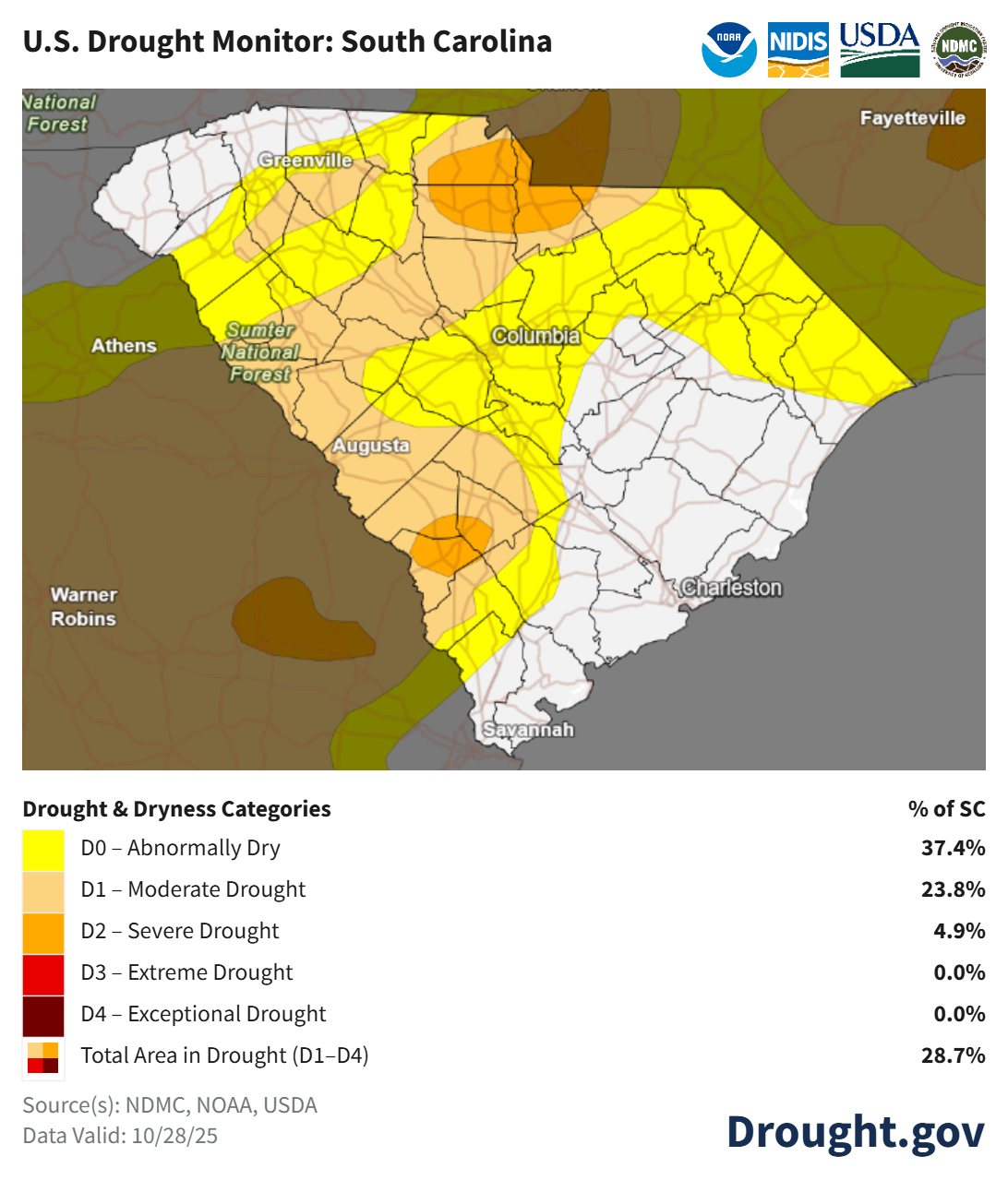
The soaking rain we had earlier in the week helped ease our drought, but much of the state remains in drought. This week’s U. S. Drought Monitor was compiled on Tuesday, so it doesn’t reflect the full impact of the rain we had.