

By Frank Strait
Severe Weather Liaison
S.C. State Climate Office
Tropics Quiet
With Fernand having come and gone over the past week (staying far from us and relatively weak), we have returned to a tranquil situation across the tropical Atlantic. We have no storms to track at the moment, and we have only one potential development over the next week.
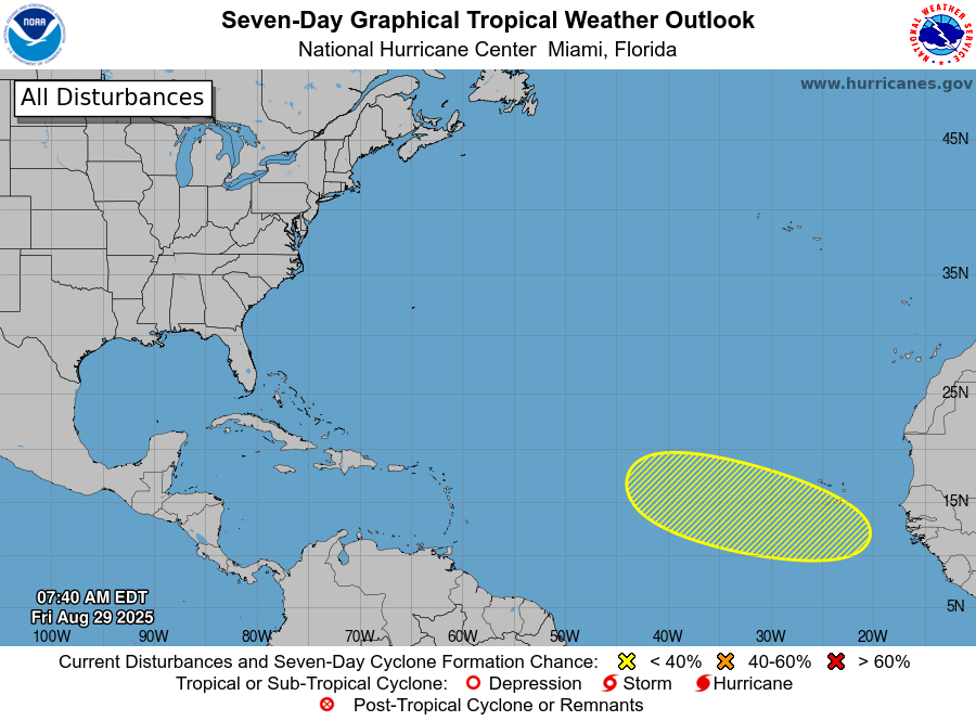
We have four tropical waves to track. One is located over the western Caribbean Sea, along 80° west, and is disorganized; it will soon move over Central America. Another is located over the eastern Caribbean, near 65° west, and is also weak, with little thunderstorm activity. That should reach Central America over the weekend with little fanfare. One more wave that is devoid of showers and thunderstorms is along 52° west, just east of the Lesser Antilles. The other tropical wave is over the far eastern Atlantic near 28° west, and it also has little associated thunderstorm activity.
The wave over the far eastern Atlantic is the only one with any chance to develop further, with only a 30 percent chance of doing so over the next week, according to the National Hurricane Center. That could be generous; I scraped the bottom of the barrel but couldn’t find a computer model that shows the feature developing.
Thank the Madden-Julian Oscillation for the break in activity over the Atlantic Basin; its current state features an area of sinking air covering the Atlantic tropics. Sinking air suppresses thunderstorm activity, making tropical cyclone formation much more difficult. The MJO drifts eastward in time, and we can expect more favorable conditions to spread over the Atlantic for a period of time later next week and the following week.
None of the tropical waves over the Atlantic today is likely to benefit from improving conditions, but two robust waves over Africa right now could. However, early signs indicate that any storms that form next week will stay out over the Atlantic, taking a quick northward turn. Of course, there are no promises at this range.
Our weather pattern for the next couple of weeks will feature a stationary front over the northern Gulf of Mexico and off the Southeast Coast much of the time. As you’ve heard me say before, that’s a setup for surprise developments close to home. However, none of the computer models predict any tropical cyclones forming in this manner.
The tropical Atlantic is quiet, and that’s how we like it. However, we’re still not yet at halftime of the hurricane season, so you need to remain prepared. If you need help with getting prepared, hurricane.sc is the place to go.
Unsettled and Cool This Weekend
Nobody’s complaining about our continued stretch of below-average temperatures and humidity. It was certainly nice not to be completely drenched with sweat after playing pickleball last night! High pressure is nosing in from the north, giving us a beautiful day today, with most of the state experiencing sunshine and low-to-tolerable levels of humidity.
However, a slow-moving storm over the nation’s midsection today is moving our way and will bring a wet Saturday to parts of the state. Rain will mostly stay confined to the Lowcountry with just spotty showers elsewhere. Clouds and rain keep temperatures down across the south, with temperatures likely remaining in the 70s. Further north, expect highs in the upper 70s to lower 80s, with the sun peeking through at times.
That storm moves out to sea Saturday night, but we’re going to see a second one drop in from the north on Sunday. That will keep much of the state cloudy with additional rain and drizzle. The heaviest rain is most likely to remain south of I-20, but there is uncertainty due to our computer models not being in good agreement on what will happen. The temperature forecast is also tricky. If it remains mostly dry north of I-20, it may be pushing 80°, but if steady rain falls that far north, then even 70° could be a struggle. To the south, it likely reaches the 70s and low 80s, depending on how much sun can peek through. Warm and muggy conditions in the Lowcountry will lead to some thunderstorms, which can be locally heavy. There could even be isolated flash flooding.
We can expect to see improvements on Monday as drier air moves in from the northeast. However, our coastal areas likely start the day with clouds and possibly some leftover rain. Away from the coast, sunshine is likely to prevail, with highs in the upper 70s to lower 80s, making for a nice day.
Tuesday should be another nice day before it turns unsettled again at midweek. A new cold front approaches that day, causing a stationary front to our south to retreat northward as a warm front. That leads to an unsettled Wednesday with showers and thunderstorms, but there is uncertainty on how widespread that activity will be. Thursday will likely be warm and muggy but mainly rain-free. Then, the next cold front is likely to reach us at the end of next week, bringing another chance for showers and thunderstorms. It’s too early to make promises, but the early signs are that we’ll have nice weather next weekend.


