

By Frank Strait
Severe Weather Liaison
S.C. State Climate Office
The Atlantic tropics have perked up in recent days with Tropical Storm Dexter forming east of the Outer Banks and moving out to sea. More favorable conditions are spreading across the basin as the Madden-Julian Oscillation (MJO) continues its eastward drift. So, this afternoon’s Tropical Weather Outlook graphic from the National Hurricane Center (NHC) has a busy look.
Included in the outlook is an area just off our coast with a 40 percent chance to develop into a tropical cyclone in the coming days. There’s nothing in that area but a few thunderstorms right now. We expect to see low pressure develop out there as the stationary front (the one that brought us a wonderful end to last week’s heat wave and also spawned Dexter) currently stretching from Georgia to Virginia shifts back out over the water later this week.
There will be a lot of uncertainty in the forecast about what will happen off the Southeast Coast until the stationary front gets back out over the water again and sits there for a day or two, so we won’t really have a good idea of what will happen until Thursday or perhaps Friday. Right now, our computer models show that the storm we expect to form will remain weak and mainly offshore, more of a concern for North Carolina than for us, so that seems most likely. However, we can’t rule out the possibility of a stronger storm that could take a track that impacts us. So, we will have to watch this area closely over the next few days to see what evolves.
The primary reason for today’s edition was to give y’all a heads-up about the risk for a storm to develop nearby without much time to react. However, I wanted to say a few words about the risks we face over the next couple of weeks. I’m sure some of y’all have noticed social media posts about the computer models showing scary forecasts of a hurricane hitting South Carolina or passing close enough to raise a serious ruckus here.
It’s to be expected that the models would show more activity and even intense hurricanes forming in the Atlantic, thanks to the improving environment for them on this side of the world, because of the approach of the MJO’s thunderstorm-enhancing phase. However, please keep in mind that the computer models are not usually suitable for forecasting specifics beyond about a week out. Sometimes you can use them for that if they’re being consistent run-to-run and are in close agreement, but we’re not in one of those situations. There’s some agreement that we’ll see tropical cyclones form and they might become hurricanes in the coming days, but very little agreement on where they might go.
So, take those posts from supposed authorities on social media with a large grain of salt … like one the size your outdoorsy neighbor might put out for the friendly neighborhood deer herd to enjoy. Don’t get me wrong, there are plenty of reliable sources for weather information that are active on social media, such as your local National Weather Service office, your local TV meteorologists, private weather services, and storm chasers. But think twice before you buy into a post showing a hurricane hitting Charleston 15 days from now by some rando whose name you don’t even know. Rule Number One of social media is that if you don’t know the poster’s name and it’s not a well-known organization, be skeptical, especially if it’s a post about long-range doom and fright.
All that being said, we will probably see a storm form from that other orange area over the middle of the Atlantic in 3-5 days, and it could become a hurricane. Odds favor it taking a track over or east of Bermuda, though. A tropical wave that will emerge from Africa later this week will have a good chance to develop over the Atlantic next week. The earliest signs point toward it taking a track into the Caribbean Sea. It’s too soon to say where it might go from there, but we have a long time to think about it. So, keep your popcorn handy.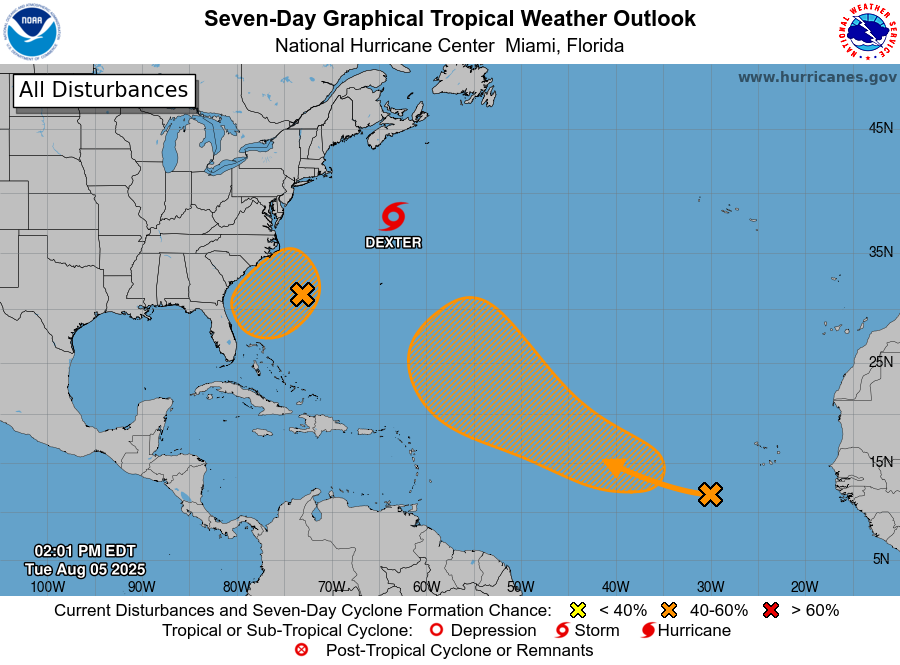
As always, it’s better to be prepared than not prepared. We’re about to hit the most active part of the hurricane season (mid-August to mid-October), so if your hurricane supply kit is missing some essential goods, now is the time to fill them up. “What’s a hurricane kit?” you said. You can find the answer to that and a ton of other storm prep advice at hurricane.sc.
WEATHER ALERT: Tropics Perk Up, Watching the Southeast Coast


