


By Frank Strait
Severe Weather Liaison
S.C. State Climate Office
Key Points:
-Winds will become strong tonight as a cold front approaches South Carolina. Wind gusts of 40-50 mph may occur late tonight and early Wednesday before of a line of thunderstorms associated with the front arrives.
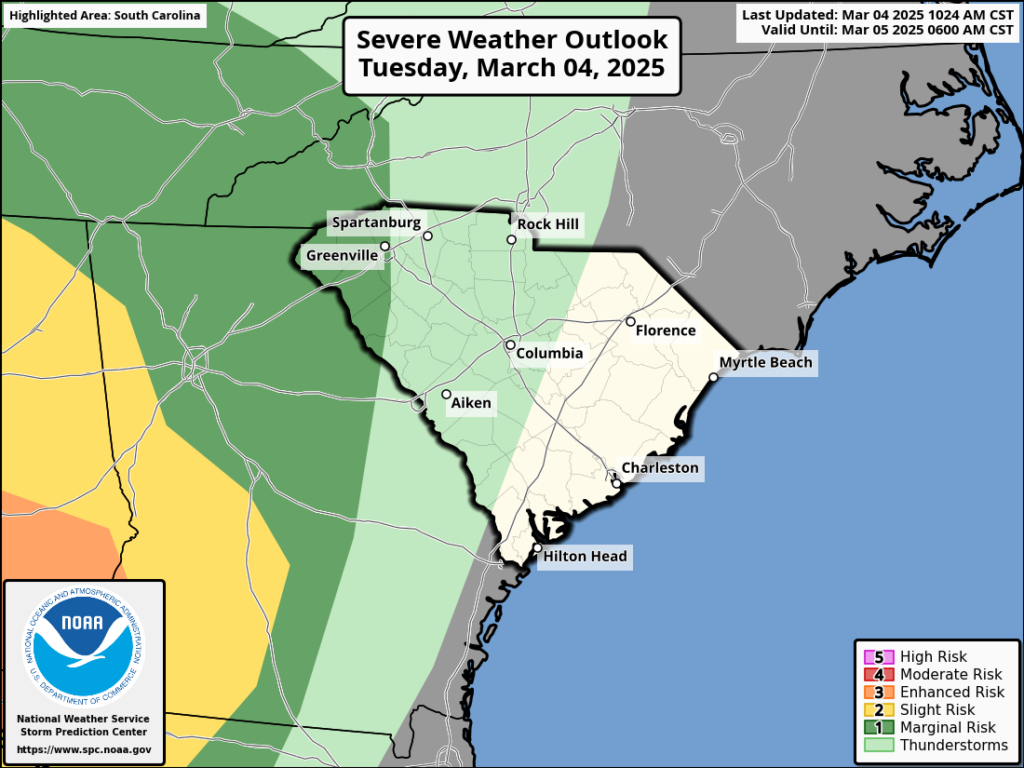
-The line of thunderstorms will be severe in some areas with damaging winds; the damaging winds could be widespread. There will be a risk for isolated tornadoes as well, especially in the Pee Dee and Lowcountry. Arrival times for the line of storms are as follows:
* 3-6 a.m. across the Upstate (from west to east)
* 6-8 a.m. across the Central Savannah River Area
* 7-9 a.m. along the I-77 Corridor (Rock Hill to Columbia Metro)
* 8-11 a.m. across the Lowcountry
* 10 a.m. to 1 p.m. across the Pee Dee; around midday for the Grand Strand
-Dry and blustery conditions return Wednesday night into Thursday. Areas that do not see substantial rainfall from the thunderstorms may have fire weather concerns on Thursday afternoon.
-Friday looks dry and perhaps breezy. If it’s windy enough, there may be fire weather concerns in some areas.
-Needed rain is possible Sunday into Monday, especially along the coast where it is needed most.
We’re still on track for very active weather later tonight through much of Wednesday, and the concern for severe thunderstorms has increased.
A storm over the nation’s midsection today is the culprit. The storm center will track toward the Great Lakes and pull a cold front over eastern Oklahoma and Texas across South Carolina.
Winds will increase tonight and become strong late, ahead of the approaching front. Even well ahead of the thunderstorms, wind gusts may reach 40-50 mph across the state late tonight and Wednesday morning.
However, the strongest winds will occur with a line of thunderstorms ahead of the cold front. That likely reaches the western Upstate around 3 a.m. and marches at double time across the state, moving offshore from noon to 2 p.m. At least, that’s the best estimate I can give; squall lines like the one we’ll see blow through late tonight and Wednesday tend to move faster than we expect.
This is a situation where very strong winds will occur aloft at the same time as the thunderstorms move through, which is ideal for causing damaging wind gusts at the surface where you and I live.
For Wednesday, the farther east you are, the greater your risk of damaging wind from the line of thunderstorms. In the Upstate, peak wind gusts will be around 60 mph as the storms move through, but 40-50 mph gusts could be widespread. Farther east along I-77 and U. S. 321, the peak gust potential increases to the 60-70 mph range, with many places seeing gusts to around 50 mph. The Pee Dee and the Lowcountry have the highest risk for damaging wind, as 50-60 mph gusts could be common, with a chance for peak gusts over 70 mph.
We’ll also be at risk for isolated tornadoes. This applies to the entire state, but eastern areas have a greater risk than the west because the line of storms reaches the coastal areas at midday and early afternoon, after there’s time for limited sunlight to warm things up.
Thanks to increased confidence in high winds and the risk of isolated tornadoes, the Storm Prediction Center (SPC) has increased the risk level for Wednesday in its outlooks.
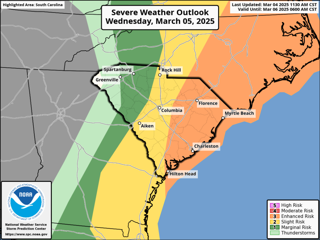
When SPC has you in a level 3 (enhanced) or higher area on their outlooks, they mean business. You’ll want to prepare this evening. For example, any loose items in your yard that can blow around should be secured. You’ll also want to take some time to review your tornado emergency plans, especially if you are in the enhanced risk area where the tornado risk will be highest. As always, you can find help with severe thunderstorm and tornado prep from SCEMD and the National Weather Service.
Gusty winds will continue through Thursday behind the storms, but they won’t be as strong in the wake of the storms as we expect to see ahead of them and with them. Winds will gust past 30 mph through Wednesday night and Thursday, pushing dry air back into the state. Hopefully, the thunderstorms will bring us enough rain to lower the wildfire risk for a while, but areas that don’t see much rain might be at risk again Thursday afternoon. Friday looks very dry and possibly breezy enough for fire weather concerns, so we’ll keep an eye on that, too.
A complicated weather situation will bring chilly rain to at least parts of the state on Saturday night through Monday. There are timing questions, and we’re not sure how far north a storm system moving through our part of the world will track during this time. It sure would be nice to get more rain—we need it!


