By Frank Strait
Severe Weather Liaison
S.C. State Climate Office
S.C. Department of Natural Resources
Key Points:
-All of South Carolina is at risk for a severe thunderstorm outbreak Sunday. Damaging wind is the primary threat, but there can be large hail and isolated tornadoes.
-The most likely timing is for the Upstate to be at risk during the morning, then storms shift to the Central Savannah River Area, Midlands, and Catawba River Area during the midday and first part of the afternoon, and then mainly for the afternoon across the Coastal Plain.
-There remains some uncertainty about the timing; maybe the situation will progress slower.
-In addition to the severe storm threat, heavy rainfall in the Upstate could lead to minor flooding.
-It’s important to have a sheltering plan in place ahead of a potential severe weather outbreak. The National Weather Service has plenty of tornado and severe storm prep advice if you need it.
We remain on track for an outbreak of severe thunderstorms on Sunday. The latest outlook from the Storm Prediction Center (SPC) puts the entire state in a level 2 of 5 ‘Slight Risk’ area for severe storms on Sunday.
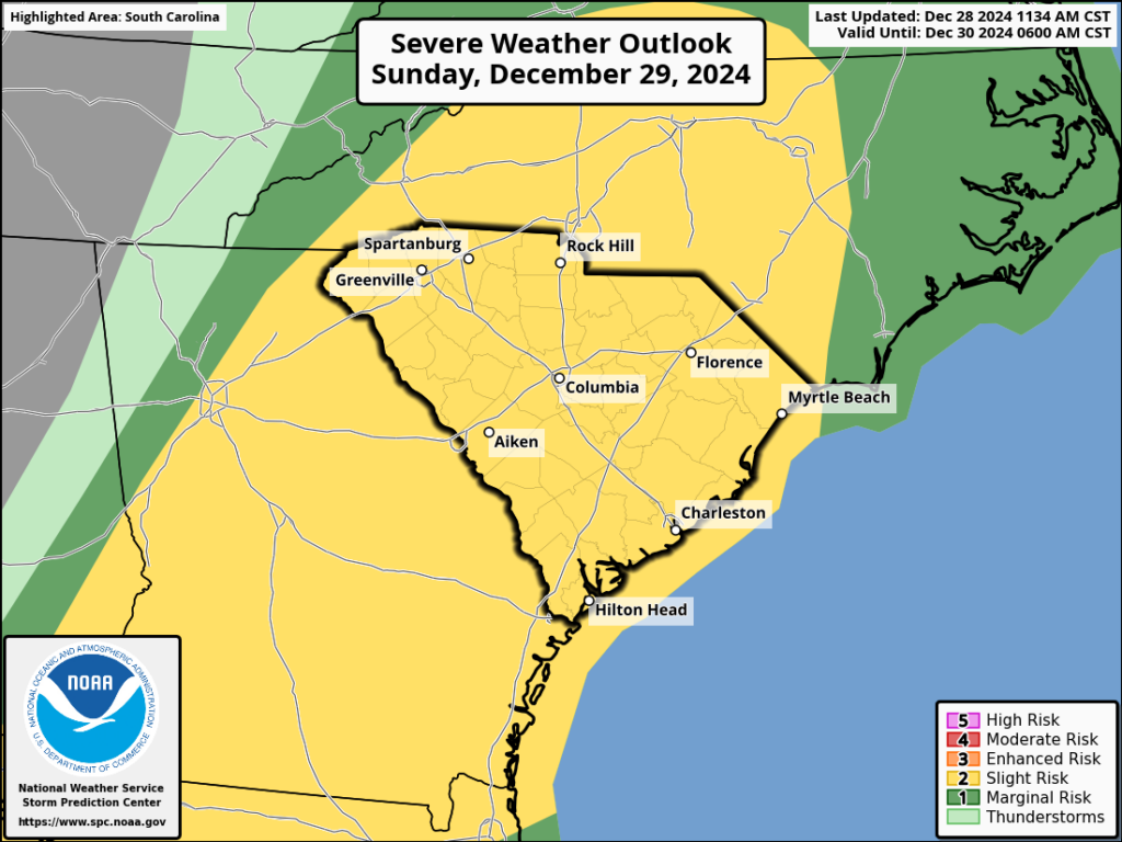
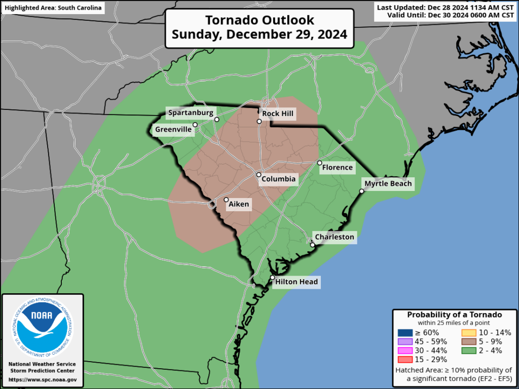
The primary concern for Sunday will be locally damaging wind. Large hail may occur with stronger storms during the afternoon as they cross the middle parts of the state. There can be isolated tornadoes as well, and SPC has outlined a part of the Central Savannah River Area (CSRA), Midlands, and Catawba River Area with a somewhat elevated risk for tornadoes since that area will have the best combination of warm, unstable air in place and favorable wind shear.
The timing of the severe storm risk remains somewhat uncertain, but for now, it appears the Upstate will be affected mainly during the morning. Then storms will shift into the CSRA, Midlands, and I-77 Corridor for the midday and early afternoon, then along the Coastal Plain the rest of the day. Storms may linger into the early evening along the Grand Strand. Our computer model guidance has been erring on the side of ‘too fast’ so far, so don’t be surprised if things proceed slower. That might be good for the Pee Dee if storms don’t get there until after it gets dark, resulting in a cooler and more stable atmosphere in place when storms arrive.
It’s also worth mentioning that the Upstate will get a good soaking rain through Sunday between a warm front lifting northward and a cold front moving through and triggering the potentially severe storms.
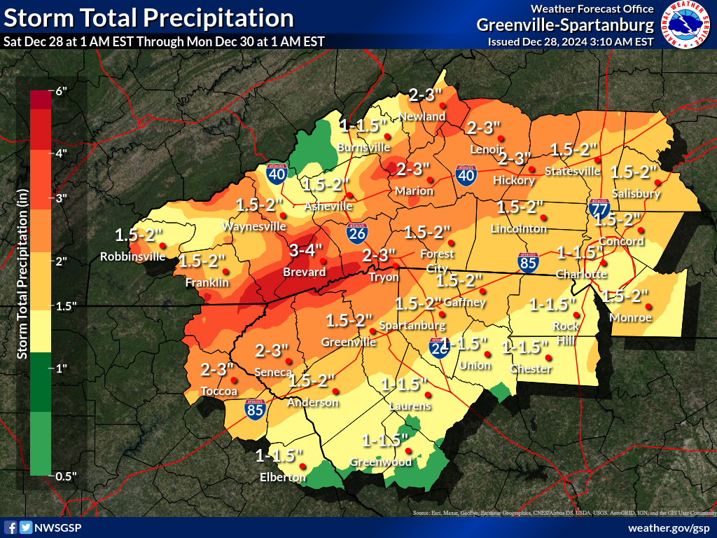
This much rain won’t cause any widespread flash flooding or river flooding (there’s some worry for it up in the land of tomato-vinegar hybrid sauce if you’re traveling or know someone up there). However, there can be some poor drainage flooding and isolated flash flooding from the more intense downpours.
Once again, I urge y’all to review your severe storm and tornado sheltering plans so that you’re ready to take cover if required. Hopefully, this will just turn out to be a drill for our tornado prime time in the spring, but the risk is there and it’s best to be ready.
Looking ahead, we’ll get a couple of nice days on Monday and Tuesday as highs reach the 60s and 70s before we trend back to a colder weather pattern. While I have your attention, I’d like to let y’all know that the weather pattern is going to favor sustained cold for a while starting later next week, with the risk for extreme cold while we’re in the cold pattern. Mid-January is the worst time to be in a cold weather pattern since it’s the coldest time of year.
So, I recommend taking some time to winterize your home and car while it’s still warm in case a worst-case scenario comes to pass (like we saw at Christmas of ’22, for example). Wrap those pipes if you haven’t already, get your outdoor spigots covered, and make sure your car’s antifreeze can handle the cold if it’s more than a few years old. I’m sure you can think of other things you can do to fit your situation.
I’m also sure you’re wondering if we have a risk of a winter storm in the coming weeks since it looks like a boatload of cold air is incoming. The short answer is yes, the weather pattern we’ll be in allows for it, but right now we don’t have any strong sign that winter storm ingredients will come together. Think of it like this:
You’re 10 and hoping Mom will bake a chocolate cake or cupcakes. Here’s the situation:
There’s nothing in the oven baking (that would be like a Winter Storm Warning if she had the oven on)
Mom’s not in the kitchen and there aren’t any cake ingredients on the counter (that would be like a Winter Storm Watch)
However, Mom just got home from the grocery store and is putting sugar, flour, cocoa powder, butter, and so forth into the pantry. You asked and she said, “Maybe if you’re good, one day when it’s cold and I want to have the oven on.”
So, be on your best behavior if you’re craving a snowstorm.
Full credit to Brad Panovich up in Charlotte for most of that analogy, by the way.


