


Beware the Day After the Ides of March
By Frank Strait
Severe Weather Liaison
S.C. State Climate Office
Key Points:
-A significant severe thunderstorm event, with the potential for widespread damaging wind, large hail, and potentially strong tornadoes, will affect all of South Carolina on Monday.
-The severe storm risk will begin in the far northwest early Monday, possibly before daybreak, and storms will march eastward through the day before exiting over the Atlantic during the evening.
-It’s critical to have a sheltering plan in place before the outbreak; make one tonight if you haven’t already.
-Unseasonably cold air will move in behind the cold front triggering Monday’s storms, and a damaging freeze is likely for much of the state Tuesday morning and especially Wednesday morning.
I’m sure that the 80s kids who also had to read Julius Caesar feel a chill after THAT headline.
Y’all, we’re in for a potentially ugly day of severe thunderstorms and tornadoes on Monday. There are no significant changes to the forecast. Any thunderstorm we see through this evening can be severe, with locally damaging winds and an isolated tornado, but storm coverage will be limited. Showers, yes, widespread thunderstorms, no. But the thunderstorms we do see can be nasty.
The main event comes Monday. The setup favors a significant severe thunderstorm outbreak with widespread damaging winds, hail in some areas, and tornadoes that could be significant. A “significant tornado” is one rated EF-2 or higher on the Enhanced Fujita Scale for tornado ratings; an EF-2 can do serious damage, like tearing the roof off your house, and the scale goes up to EF-5 (which would demolish your house and carry the bits away … we’re thankful we’ve never had one of those in South Carolina, but we’ve had some EF-4’s).
How serious does it look? In terms of magnitude, I think we can draw comparisons to the tornado outbreaks on April 13, 2020, and April 5-6, 2022. Those should be fresh in South Carolinians’ memories. Of course, the area at greatest risk will differ on Monday from that during those two events. The latest outlook for Monday from the Storm Prediction Center (SPC) spells that out.
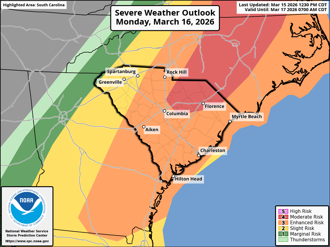
The latest SPC outlook for Monday has the entire state covered by a severe risk area, peaking at level 4 of 5 ‘moderate’ risk over parts of the Midlands and Pee Dee.
Thunderstorms ahead of an approaching cold front will arrive early in the day, possibly pre-dawn, in the western Upstate, and the line will plow eastward as the day wears on. We’ll see the storms near a line from Aiken to Rock Hill at noon, then it will continue sweeping eastward before moving offshore during the evening. The areas where storms will occur during the warmest part of the day will be at the highest risk: the Central Savannah River Area, the Midlands, and the Coastal Plain.
We’ll all hope and pray that the tornadoes we’ll see track over unpopulated forest and demolish a bunch of trees and not homes. However, you have to take time to prepare, because having a plan in place is the key to reducing your risk and possibly even your chances of survival when severe storms and tornadoes threaten you. You’ll want to know where to go (interior room, basement, break room, designated shelter in your workplace) and what equipment to have in your shelter area. You’ll get more tips on severe weather and tornado safety from the National Weather Service and SCEMD.
Some other thoughts:
-Have multiple ways to receive warnings. Having the TV tuned to your favorite friendly neighborhood meteorologist is one option; your phone’s emergency alerts are another; and a weather radio is another. That way, if one fails for some reason, you have one or more backups.
-If you own a helmet, be it a motorcycle helmet, bike helmet, or hard hat, put it in your shelter for the day so it’s ready to put on should you have to move there for a tornado warning.
-Dress for the day; it’s a day to wear sturdy clothes and shoes, not the cute little ballet flats you found on Shein with the one-millimeter-thick soles that will do you little good if you have to walk over jagged storm debris.
-If you own a whistle or air horn, keep it in your shelter so you can alert rescuers if you get trapped in there.
Finally, if you have tender plants out, plan to protect them from the cold coming after the cold front. We’re going to see a freeze over much of the state Tuesday and especially Wednesday mornings, and a few spots may get down to freezing Thursday morning as well.