
By Frank Strait
Severe Weather Liaison
S.C. State Climate Office
Key Points:
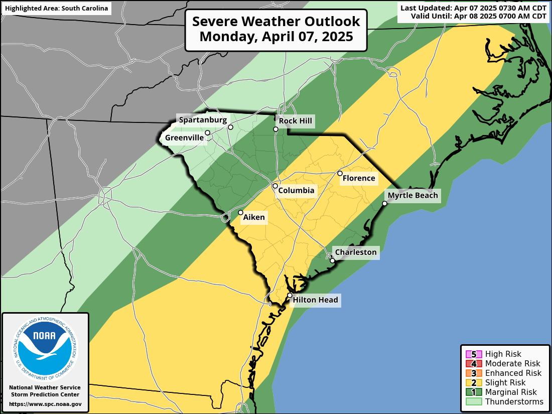
Most of the state is at risk of severe thunderstorms through this evening. The main area of concern is over the Midlands, Pee Dee and southern Central Savannah River Area.
The primary risk is locally damaging wind, but there can also be a few isolated tornadoes.
A chilly air mass will move in behind the front, and there is a risk for frost over some northern parts of the state Tuesday night into Wednesday morning.
A slow-moving cold front will cross South Carolina this evening, bringing thunderstorms, some severe. The Storm Prediction Center has most of us outlined with a severe storm risk on their latest outlook for today and tonight.
Our primary concern with any thunderstorms over the Palmetto State today will be for locally damaging wind gusts, but there is also a risk of isolated tornadoes. Any tornadoes should be brief and relatively weak, but I must stress that the Surgeon General has determined that even the weakest tornado is hazardous to your health.
You’ll want to move indoors ahead of thunderstorms and be ready to take shelter fast if a tornado warning comes out for your area. Please decide on your shelter in advance because you might not have time to do that when you’re under a tornado warning. The National Weather Service and SCEMD have more tornado safety and prep advice for you.
Today’s silver lining is that most places in the state will get a good soaking from slow-moving thunderstorms. We need the rain, but it will be heavy enough to cause standing water on roads and poor drainage flooding in some areas. So, be careful traveling in the rain today.
Behind the front, we return for a few days to late February as unseasonably chilly air moves in. You’ll notice this more with the morning lows than the afternoon highs, as sunny days will result in comfortably cool afternoons. However, each morning will be pretty chilly Tuesday through Thursday, with Wednesday morning the coldest.
It doesn’t look as cold as feared late last week, but much of the Upstate, Catawba River Area, upper Pee Dee, and Northern Midlands are at risk for frost on Tuesday night and Wednesday morning. If you live in these areas, you’ll want to be ready to protect the tender plants you might have outdoors.
After today, our next chance for rain will come Thursday night into Friday as another cold front moves through. There might be a thunderstorm, but the severe storm risk looks minimal. We’ll get another chilly shot this weekend behind that front.