By Frank Strait
Severe Weather Liaison
S.C. State Climate Office
S.C. Department of Natural Resources
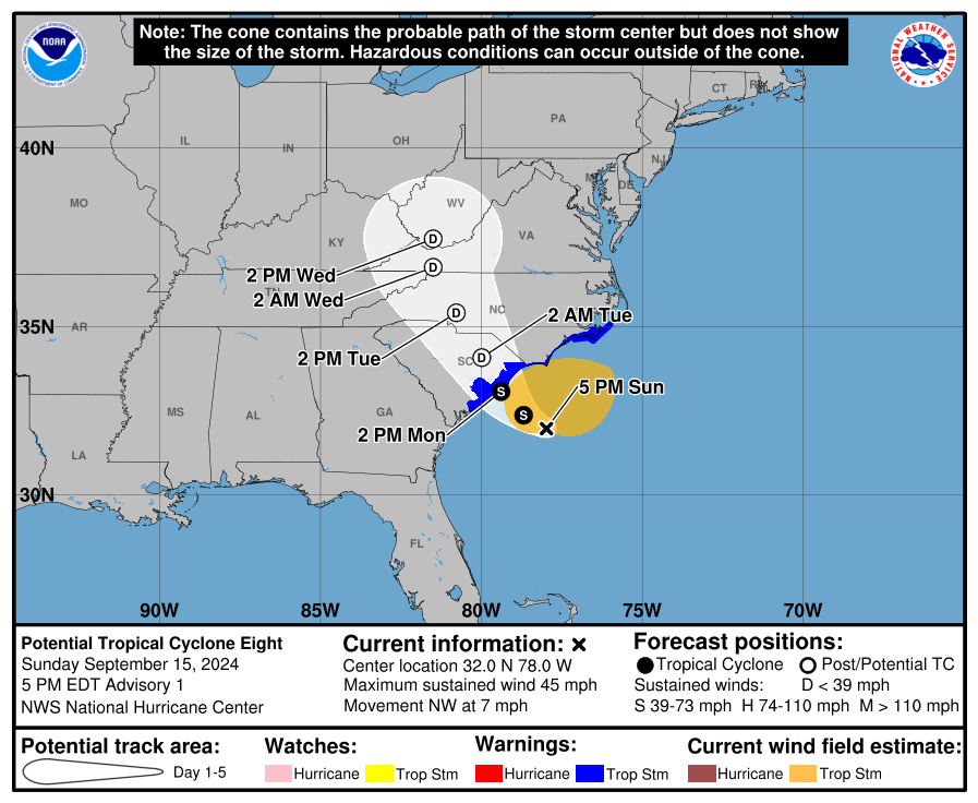
The National Hurricane Center (NHC) issued the first advisory on Potential Tropical Cyclone Eight at 5 p.m., which includes a Tropical Storm Warning from Edisto Beach northward along our coast and into North Carolina.
The developing coastal storm will bring significant impacts to the Pee Dee along with parts of the Lowcountry, Midlands and eastern Upstate through Monday night. There are questions about track, intensity and timing because the storm is in its formative stage, but the storm is likely to be a tropical storm, a subtropical (hybrid) storm, or a midlatitude storm with similar impacts.
Wind gusts will peak in the 40-50 mph range in the areas mentioned above. This will down a few trees and power lines here and there but the winds won’t be strong enough for structural damage.
Heavy rainfall of 3-6 inches over the eastern part of South Carolina through Tuesday with locally higher amounts around the Pee Dee can lead to isolated flash flooding, but river flooding is unlikely because of recent dry weather.
With astronomical tides already high due to an upcoming full moon, a small storm surge of 1-3 feet would result in moderate coastal flooding should it occur near high tide.
There can be a few isolated tornadoes Monday and Monday night as this storm pushes ashore. The best chance for an isolated tornado will be near the Grand Strand.
The anticipated coastal storm is taking shape about 125 miles southeast of Georgetown this afternoon as thunderstorms cluster around a developing low-pressure area over the warm Gulf Stream waters. The Hurricane Hunters are flying around in the storm. They have found tropical storm force wind and a broad circulation but the feature doesn’t qualify as a tropical cyclone now.
While upper-level winds are causing some vertical shear, waters in this area are generally 80-84°F and warm enough to support tropical cyclone formation. The National Hurricane Center gives this feature a 50% chance to become a named storm before it moves ashore on Monday. If it does become a tropical or subtropical storm (a hybrid between a tropical and midlatitude storm), the next name on this year’s list is Helene.
No matter the storm’s character, parts of South Carolina will have significant impacts. The finer details of how much of the state will get heavy rain are still in question because the storm is still in its formative stage. Until a well-defined storm forms and we have a chance to run the following computer model cycle, forecasts will have more uncertainty than we’d like. Most of the computer guidance we have indicates the center of the storm coming ashore over or near the Grand Strand on Monday afternoon or evening and that seems like the best forecast for now.
This would result in heavy rainfall and strong winds occurring over the Pee Dee and adjacent areas, with a storm surge along the Grand Strand. The intensity of these will depend on how strong the storm gets, but right now it appears that a strong tropical storm (or equivalent non-tropical storm) would be the worst-case scenario. The most likely situation is for a mid-range tropical storm (or equivalent) to move through.
That would bring 3-6 inches of rain to much of the Pee Dee region with locally higher amounts through Monday night. Areas farther west into the Lowcountry, Midlands and Upstate can get 1-3 inches. The rain would fall in a short enough time for flash flooding in some areas, but it’s been so dry since Debby that river flooding should not be a big concern. However, we won’t know for sure until we see how much rain falls in the parts of North Carolina that drain into our rivers.
Winds will be strong enough to take down a few trees and power lines here and there, but it’s unlikely to be widespread. Most areas will see peak wind gusts in the 40-50 mph range, but some higher gusts to perhaps 60 mph may occur along our coast.
Storm surge will depend on how strong the storm gets, its track, and the timing of the storm coming ashore. It will be capable of causing a foot or two of surge, maybe three feet if it gets strong enough. Should it occur at high tide, it would lead to moderate coastal flooding because we already have high astronomical tides from the full moon coming on Tuesday. If heavy rain falls at the same time, then the flooding would be even worse. However, if the surge happens closer to low tide, it won’t cause any problems. Also, the further north the storm tracks, the less of South Carolina’s coast will experience a storm surge.
As with all tropical cyclones and storms that try their best to be one, there will be a risk for a few isolated tornadoes Monday and Monday night along and east of the center path, particularly along the Grand Strand. We have already seen one waterspout move ashore and become a tornado over Bald Head Island, NC.
The storm likely pulls away to the north on Tuesday, but some models keep it rainy over parts of South Carolina into Tuesday night into Wednesday. It will likely become stationary over North Carolina and Virginia during this time, but there’s a chance it will stall further south. This could mean some heavy rain for parts of the Upstate continuing into Wednesday, but this will be generally welcomed because much of the region is still in a drought.
The rest of next week looks unsettled because the storm’s remnants likely get pushed back to the south into South Carolina as a cold front moves in from the north. While there can be local downpours, recent dry weather makes a wet spell needed and welcome.
Look for an update Monday morning, sooner if necessary; hopefully by then we’ll have a good idea of how much impact the storm will have on us.
WEATHER ALERT: Pee Dee Wind and Rain From PTC8 Forecast