By Frank Strait
Severe Weather Liaison
S.C. State Climate Office
The tropical Atlantic remains quiet today with no features of interest. It’s likely that we won’t see any more tropical cyclone activity in the Atlantic until next season. The view from the GOES-East weather satellite shows no features of interest across the Atlantic tropics and a few extratropical storms moving across the ocean and the contiguous United States.
If you dig deep enough, you’ll find at the bottom of the barrel a computer model or two showing a low chance of a tropical cyclone forming in the western Caribbean Sea in 10 days or so. That looks unlikely to me; December storms are rare. However, if one were to form going forward, that’s where it would happen.
With the Atlantic hurricane season winding down and no prospects on the horizon for any more storms to worry about, we’re all breathing a sigh of relief. However, it’s important to remain prepared. If it’s not something coming out of the tropics, it can be tornadoes, winter storms, and even earthquakes. So, check out those SCEMD webpages to be well-informed about disaster preparedness.
Our warm weather pattern will continue for about another week before we see a significant change. This afternoon we’ll be well into the 70s across the state, with the warmest spots touching 80°. A weak warm front will push through tonight, triggering spotty showers in the Upstate. Then Saturday might be a degree or two warmer. However, a cold front is moving our way and will pass through Saturday night. The front will bring somewhat cooler air our way, but temperatures will remain above average on Sunday. It will only be about 5° above what you’d expect in late November, as opposed to the 10-15° we’re seeing today and will see Saturday.
The cold front will trigger scattered showers Saturday afternoon and evening as it moves through. A few spots might even see a thunderstorm. However, don’t expect widespread rainfall.
Sunday will feature sunshine and highs in the upper 60s to lower 70s as an area of high pressure settles into the Southeast, making for a pretty day. Monday also looks nice, though it will start warming up again as the high slides eastward. Highs will mostly be in the 70s on Monday, upper 70s for the inland Lowcountry.
Tuesday looks warm with increasing humidity thanks to southeasterly winds around the departing high-pressure area. The southeasterly winds may pull stray showers into our coastal areas that day. Highs will mainly be in the 70s again, and may be pushing 80 in the inland Lowcountry.
We remain warm for the ‘over the river and through the woods’ day on Wednesday as a more substantial cold front arrives. The exact timing on the front is uncertain. Some models bring it through later Tuesday night, while others have it moving through during the day Wednesday. If the front arrives in the afternoon, we could see thunderstorms, maybe even a locally strong storm or two. For now, plan on showers for the trip to Grandmother’s house.
The front may still be hanging around Thursday morning, so we may see lingering showers to start Thanksgiving Day along our coast, but the rest of the state will likely be dry. We’ll also see it much cooler with temperatures dropping to typical late November readings; highs likely range from the upper 50s in the Upstate to the 60s in the Lowcountry.
Early signs are that Black Friday and next Saturday will be lovely, then next Sunday will be warmer with the next chance for rain coming our way later next Sunday or Monday.
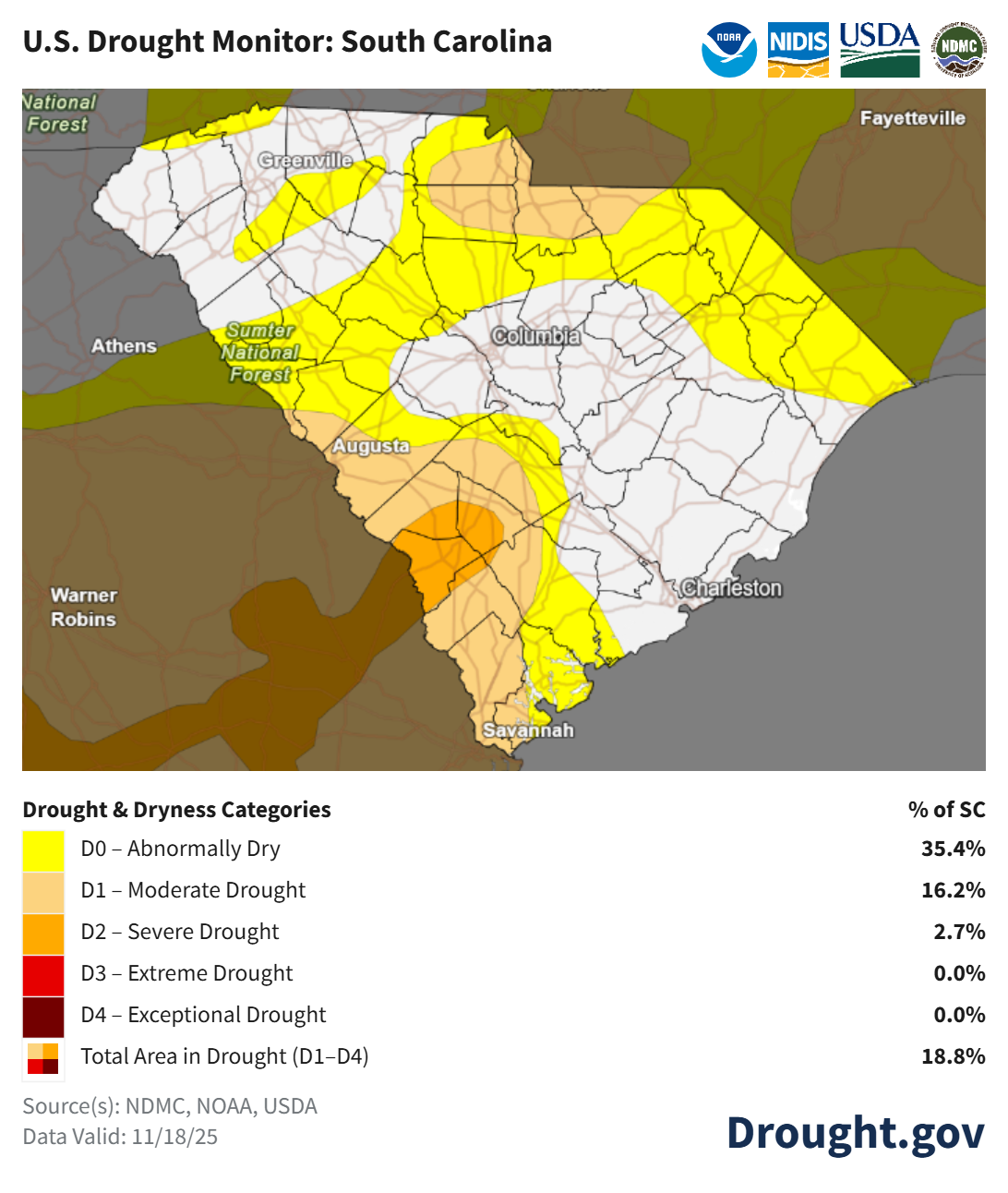
As expected, the drought situation has worsened slightly across South Carolina over the past week.
We will remain mainly dry through early next week. There is a chance for noteworthy rainfall with the midweek front next week. Prospects for rain look better for the week after next; hopefully, we’ll be able to put a dent in the drought during the first part of December.
WEATHER ALERT: Next Week’s Weather Report