By Frank Strait
Severe Weather Liaison
S.C. State Climate Office
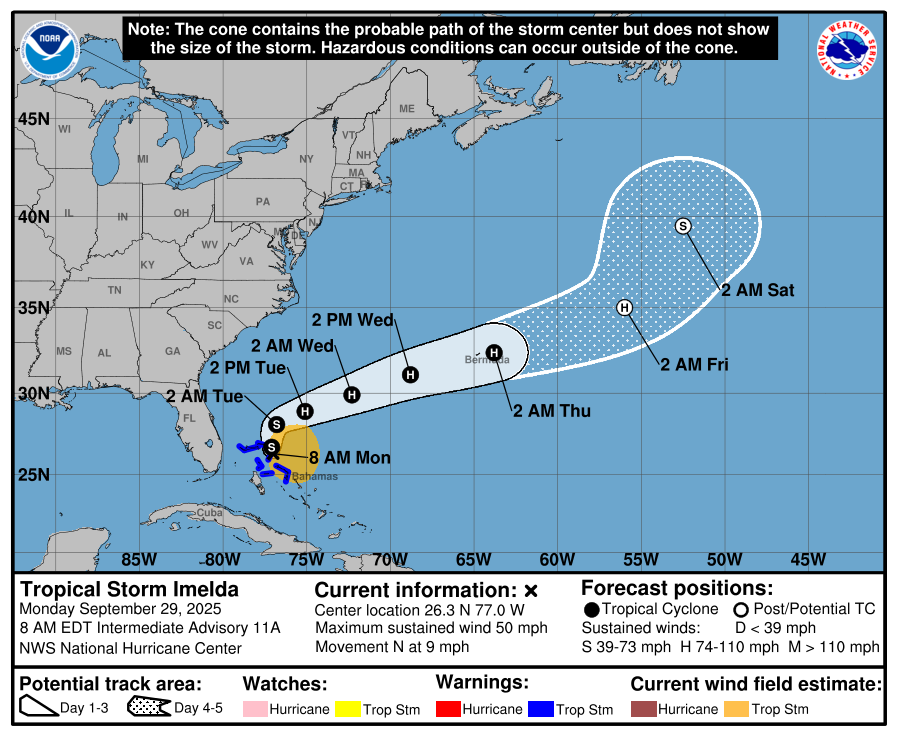
Hooray: The tropical cyclone near the northern Bahamas has strengthened and is now a tropical storm named Imelda, so I can just call it that.
Also, Hooray, but louder: We have full confidence that Imelda will turn out to sea under Humberto’s influence and have no direct impact on South Carolina.
However, it will have some indirect effects. We’ll see rough surf and a high risk of rip currents at our beaches for a while. Our coastal waters will be hazardous since both Humberto and Imelda will generate swells. We’ll also have cloudy, rainy weather through Tuesday, especially along the coast, thanks to a stationary front over the coast shifting back to the north and west due to the influence of Imelda and Humberto. That part is actually beneficial because we’ve been experiencing arid conditions lately, and because there won’t be as much rain as we initially thought. Coastal areas, especially along the Grand Strand, will receive 1-2 inches, with locally higher amounts up to 4 inches. Rainfall amounts decrease as you move inland, with most areas receiving under an inch. There may be some isolated flash flooding, mainly along our coast, through tonight.
Once Imelda moves away, the stationary front should shift south again. A sprawling area of cool Canadian high pressure will settle into New England as the week progresses, taking control of our weather and restoring tranquility to the Palmetto State. We’ll enjoy mainly sunny, delightful days and clear, cool nights later this week. Areas of late-night and early-morning fog could slow your morning commute, though. Also, easterly winds developing around the high later this week could bring some clouds and perhaps stray sprinkles into our coastal areas starting Friday.
Northeasterly winds through the period will serve to pile up water along our coast, potentially resulting in minor coastal flooding at afternoon high tide each day in the Lowcountry.
It’s too early to promise a nice weekend, as models diverge on how a weak storm system now over Mexico, Texas, and New Mexico will affect us when it arrives in this part of the country. Perhaps we stay dry, or maybe the rain from this disturbance mainly passes south but reaches some parts of South Carolina. Maybe the disturbance will spawn a tropical depression off the Southeast Coast. It’s too soon to say, but those are all possibilities.
Another feature to watch in the Atlantic is a swirl of clouds over the Gulf of Whatever that should drift southward into the Bay of Campeche. It’s unlikely that a tropical depression or storm forms out of that feature, but even if one does, it won’t affect us. Another is a tropical wave near 45° west longitude that isn’t causing much shower and thunderstorm activity. It’s slowly drifting westward and will eventually reach the central and western Caribbean Sea, where more favorable conditions for development are likely to exist.
The Imelda situation turned out to be just a big exercise for us, but exercise is good for us. You’re more ready for the next storm than you were a week ago. Hopefully, we won’t experience any more storms or scares like we did from Imelda this year, but there’s still a lot of hurricane season left. So stay ready, and if you need storm prep advice, hurricane.sc is there for you.
WEATHER ALERT: Imelda About To Turn Right