
By Frank Strait
Severe Weather Liaison
S.C. State Climate Office
S.C. Department of Natural Resources
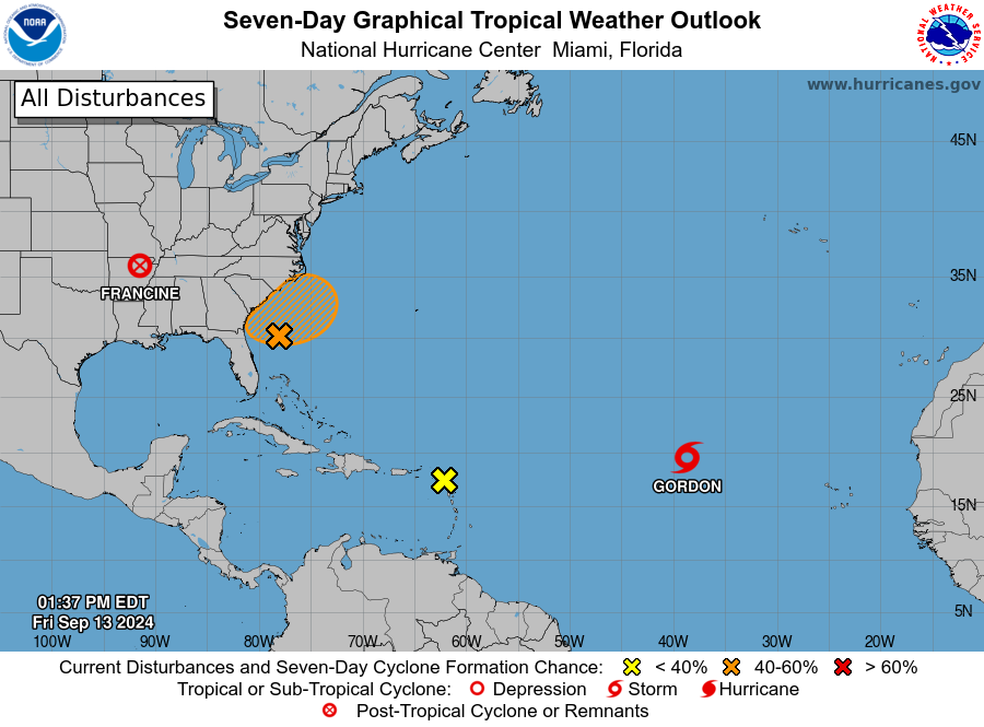
With Hurricane Francine coming and going over the last week, we only have newly named Tropical Storm Gordon and a couple of areas of interest for development on the map today.
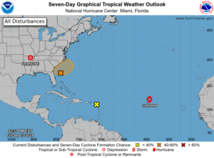
Francine made landfall in Louisiana as a Category 2 hurricane on Wednesday; it’s now post-tropical and raining itself out over the middle Mississippi Valley. It’s steering moisture from the tropics into South Carolina, but we haven’t seen a lot of rain so far. This is partly due to a vast supply of dry surface air from a high-pressure area to our north and partly due to bone-dry air aloft that came out of the southwestern states and into the Southeast south of Francine. We’ll continue to see clouds and showers through this weekend, especially tonight and Saturday, as Francine’s remnants wander to our west. A few days ago, it looked like parts of South Carolina would get a needed soaking from Francine, but the “dry air plus more dry air” formula will win this time, so rainfall totals from the storm will remain in the light-to-moderate range.
All hope is not lost of seeing substantial rain over the next week, though. Allow “Disturbance 1” to enter the chat; this is the area NHC has outlined off the Southeast Coast on the outlook graphic above. A non-tropical storm system will form in this area along a stationary front this weekend, which may become tropical or subtropical since it will sit over warm Gulf Stream waters. However, the forecast for where this storm will go and how strong it will get is uncertain. Possibilities for Monday through Wednesday here range from cool, showery, and breezy as a weak non-tropical storm spins offshore to a tropical cyclone forming and moving through the Carolinas with gusty winds, heavy rainfall, and a storm surge.
The confidence level is low, but there are a few things we know. First, there won’t be a good beach day along our coast for a while due to persistent onshore wind, showers, and rough surf. We’re also heading toward a full moon on Tuesday so astronomical tides will be going up and some coastal flooding is likely at the high tides this weekend and next week no matter what’s spinning offshore and perhaps moving onshore.
It doesn’t help that computer models have been back and forth between different possibilities for next week. Meteorologists across the region are bracing for a new round of “how do you keep your job when you’re wrong half the time” abuse due to the wide range of possibilities. That said, this morning’s computer models have returned to the idea of a storm causing significant impacts for our Pee Dee region and the Land of Vinegar Sauce, so we should be ready for potential impacts even though those models send the worst of the storm toward our neighbors to the north.
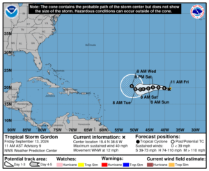
Elsewhere across the tropics today, we have freshly upgraded Tropical Storm Gordon spinning over the middle of the tropical Atlantic. Dry air and shear are keeping this feature in check and neither will relent through early next week, so Gordon is forecast to remain a weak tropical storm. It’s likely to turn north and track east of Bermuda next week, so it won’t be a factor for us unless it gets strong enough to send swells toward our coast that lead to beach and boating problems.
The other feature we’re watching today (Disturbance 2 on the outlook map above) is a tropical wave over the Lesser Antilles. Conditions are not favorable for further development in this area due to dry, sinking air in the area and vertical shear. Moisture from it will likely be shunted northward by an upper-level trough in the coming days.
There also is a new tropical wave emerging from Africa that looks robust, but it will take time to organize and development of this feature is unlikely over the next week.
As always, I urge y’all to maintain your readiness as we move through the peak of hurricane season. If you need storm prep advice, the place to go is hurricane.sc.
WEATHER ALERT: Homegrown Storm Possible Early Next Week