

By Frank Strait
Severe Weather Liaison
S.C. State Climate Office
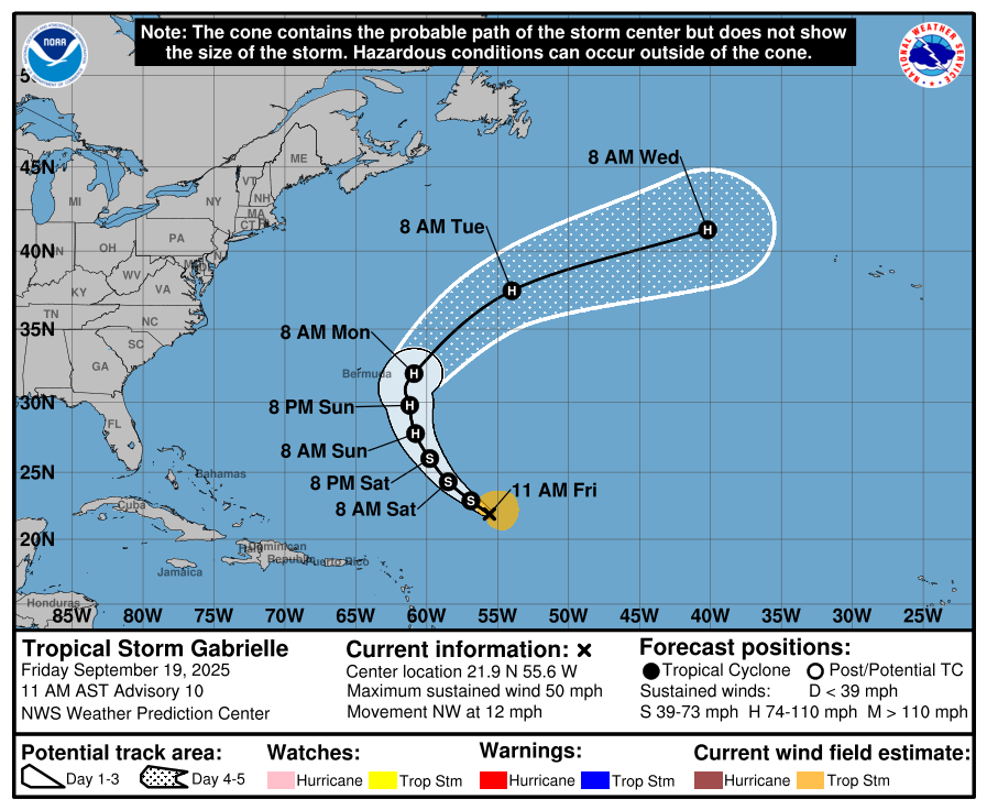
Finally, the Atlantic tropics have perked up again. The three-week stretch of inactivity we had during the peak of hurricane season was unusual, but now we have Tropical Storm Gabrielle to track.
Gabrielle has been struggling against vertical wind shear and the dry air mass that it’s passing through. However, the wind shear will lessen starting today, so Gabrielle is likely to intensify over the weekend. The National Hurricane Center (NHC) calls for Gabrielle to be a hurricane by Sunday and then pass east of Bermuda on Monday.
With it staying so far away, the only effect it will have on us in South Carolina will be on beach and boating interests next week. The severity of this will depend on how strong Gabrielle becomes over the weekend. NHC calls for Gabrielle to reach Category 2 intensity, which would be strong enough to send ocean swells toward our coast that cause an increased rip current risk and perhaps hazardous coastal waters for boaters Tuesday into Wednesday. That comes after a period of gusty northeast winds over our coastal waters that makes surf and coastal waters rough Sunday into Monday.
Elsewhere over the Atlantic Basin, we’re watching four tropical waves:
Along 72° west, south of Hispaniola
Along 53° west, which is the wave that spawned Gabrielle
Along 37° west, over the middle of the tropical Atlantic
Along 20° west, having just moved over the Atlantic from Africa
None of them gives me concern for development in the near term. The wave over the Caribbean Sea won’t develop further before reaching Central America. The one that spawned Gabrielle is unlikely to produce another tropical cyclone and should reach Central America early next week. The one mid-stream over the Atlantic is unimpressive today, but computer models tell us to keep an eye on it once it gets to the area around the Greater Antilles in about a week. The wave emerging from Africa has tons of dry and dusty air to its north, which will keep it in check for now. However, it could become a more significant concern for development in a week or so when it arrives in a more favorable environment.
There’s one other thing to mention, which is that we still have an area of disturbed weather off the East Coast from a decaying stationary front. Surprise tropical developments sometimes happen from these features, though no computer model is calling for that currently. Another cold front will move through the Southeast later next week and become stationary offshore, so we’ll have to monitor that situation, too.
While we don’t have any direct threats, the season is far from over. Maintain your readiness! If you need hurricane prep advice, hurricane.sc is the place to go.
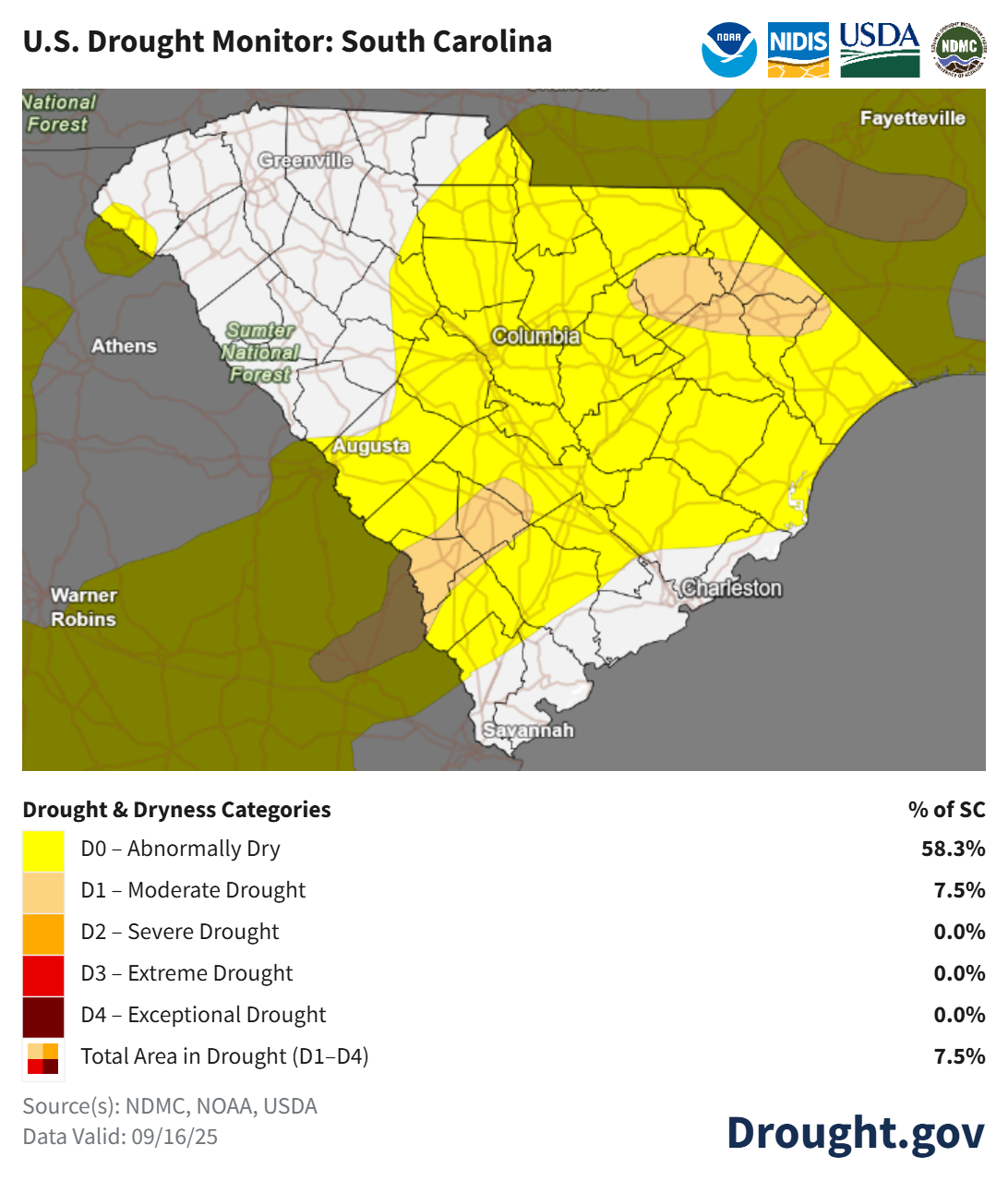
Most of the state remains bone-dry. My house is one of the driest spots around; it’s been 13 days since I’ve seen a drop, and in the 29 days since August 23, I’ve only had 0.06″. My lawn is mostly dead. At least it’s mainly mosquito-free, and even the gnats have mostly moved on for now. You find nothing but powdery sand if you dig down three feet right now. How do I know? I dug up a stump in my backyard last weekend. 0/10 on that, I do not recommend.
As a result, drought has returned to parts of South Carolina, with over half the state experiencing abnormally dry conditions.
Our prospects for rain are not great through the first part of next week. Our humidity levels are trending up, so stray showers and thunderstorms will ignite over the inland Lowcountry this afternoon, and over the northwest corner of the state as well. Saturday will bring some isolated showers and possibly thunderstorms to the Upstate. Drier air returns after that, so we likely remain rain-free across the state Sunday through Tuesday. Temperatures will remain warmer than average for late September, with highs mainly in the mid to upper 80s, with lower 90s in the hotter spots.
Changes are coming starting Wednesday or Thursday, depending on your location. A cold front will move in, which might arrive in time to bring a chance for thunderstorms and a cooler day to the Upstate on Wednesday. The rest of the state will have to wait until Thursday, with Wednesday a summery day with highs mainly in the lower 90s.
Once that cold front arrives, we will begin a period of more active weather. Thursday and Friday next week should bring widespread shower and thunderstorm activity as the front slowly moves through, then another front should bring us two or three more days with rain chances during the following week.