

By Frank Strait
Severe Weather Liaison
S.C. State Climate Office
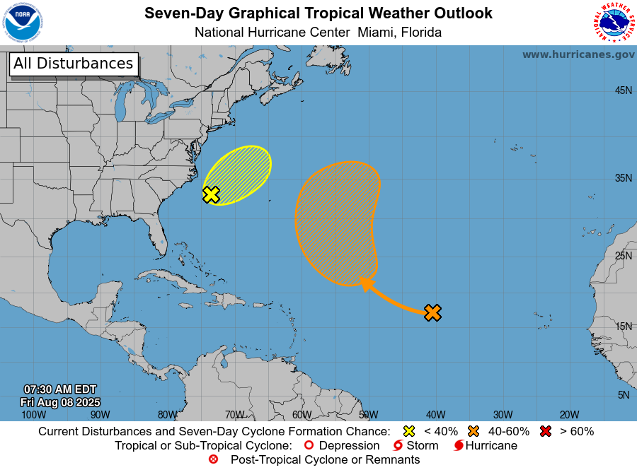
With Dexter now an extratropical entity over the far northern Atlantic southeast of Newfoundland, we have no active tropical cyclones to track in the Atlantic Basin. There are two areas to monitor for development over the basin today, according to the National Hurricane Center (NHC).
The risk of seeing a tropical cyclone develop off the Southeast Coast has lessened since Wednesday. Thunderstorm activity along the stationary front just offshore remains disorganized. Computer models are in general agreement that a low-pressure area will form east of the Delmarva Peninsula or New Jersey over the weekend. However, they are split on whether it will become a tropical cyclone. Whether or not it becomes a tropical cyclone will be irrelevant to us, as it will follow in Dexter’s footsteps and head northeastward across the ocean.
The other area that NHC is watching is a tropical wave along 42° west over the middle of the tropical Atlantic. A weak area of low pressure has formed over the northern end of this wave, but there is little thunderstorm activity around the circulation. The problem for this feature in the short term is that it is embedded in a relatively dry and stable air mass that isn’t very conducive to thunderstorms. It will encounter more favorable conditions as it moves eastward, so NHC gives it a 50% chance to become a tropical cyclone over the next seven days. The next name on this year’s list is Erin, assuming the storm that will form off the East Coast doesn’t claim it first. Fernand is the next name, if it does.
This feature will likely take a track that keeps it well to our east over the Atlantic. If that’s the case, it won’t impact us directly. However, if it becomes a hurricane, and there’s a good chance that it will, then it will churn up the ocean and generate swells that cause rough seas and surf along our coast. If that’s how it goes with this feature, then the coastal impacts would occur later next week and next weekend.
There’s one other feature out there to tell y’all about, which is a tropical wave moving over the Atlantic from West Africa today. It’s the feature that computer models have occasionally shown becoming a hurricane in a position to threaten the East Coast around the 21st.
The dry Saharan air present over the eastern tropical Atlantic should keep this feature from developing for at least the next 3-4 days, but there is high uncertainty for what happens with it after that. As is typical for events over 10 days in the future, the computer models are in poor agreement with each other and are not very consistent from one model run to the next (with some running every six hours and others running every 12 hours). So, there is very little confidence, and it’s enough of a stretch to say there’s a chance we might be affected. It may be more than a week before we can definitively make that call. Reasonable possibilities right now range from a track into the Gulf of Mexico to one near Bermuda. How strong it might be is even more uncertain. I only went into detail about this feature right now because of the volume of nonsensical social media posts I’m seeing about it.
The only useful information to be given right now is that there’s something to watch for the week after next, and we’ll have to wait and see how the situation unfolds in the coming days. The one thing you can do is something everyone in South Carolina should be doing anyway: make sure you have the disaster supplies you need, should the worst come to pass, whether it be two weeks from now or two months from now. After all, we’re just getting into the most active part of the hurricane season. If you need advice on how to get ready for storms or other disasters that can affect us, SCEMD has you covered with hurricane.sc, earthquake.sc and other sections of their website.
Things Return To Normal Soon
When the cold front that ended our heat wave moved in a week ago, I didn’t expect to see a historic stretch of unusually cool August weather, but here we are a week later, and Columbia hasn’t seen 80° since Saturday (when it was 81°). The five days of sub-80° temperatures we’ve seen in our capital ties the record for the longest such period in August. Being that we’re at 72° at 11 a.m. here with a slate-gray sky, it stands to reason that we might come up short of 80° one more time today.
Your mileage has varied; for example, Greer is working on its seventh day of temperatures below 80° and has had two days where it came up short of 70°, while temperatures in the 80s have been typical along our Coastal Plain and parts of the Lowcountry had a spike of heat with temperatures in the middle to upper 90s on Tuesday.
All good things, like unusual cool spells in August, eventually come to an end, and we’ll see a change in the weather pattern over the weekend. The unusually strong area of high pressure that has been sitting over or near New England all week will finally pull away to the east over the weekend and allow us to return to normal gradually.
So, look for the cool air ‘wedge’ that has been over us all week to break up this weekend, finally. That will result in the clouds finally parting, allowing the sun to warm us up. Our highs will reach the 80s again over the weekend; low 80s in the Upstate and middle to upper 80s elsewhere. Returning with the more typical warmth will also be daily thunderstorm chances, especially by Sunday.
Increasingly normal weather is coming next week as our highs return to the upper 80s and lower 90s by midweek, and we continue to see a daily scattering of mainly afternoon and evening thunderstorms. The exception will be immediate coastal areas, where the downpour odds will be more favorable through the morning and midday.
Another cold front may reach the southeastern states later next week to make the daily thunderstorms more widespread and bring temperatures down a bit. However, I don’t think we’ll see another long stretch of unusual cool from that front.


