


By Frank Strait
Severe Weather Liaison
S.C. State Climate Office
Erin behaved as expected and is now east of New Jersey and pulling away to the east. It remains a Category 2 hurricane, but it has begun a transition from a hurricane to an intense extratropical storm. That process will likely be completed by Saturday afternoon, but it will remain a powerful North Atlantic storm system for days.
Lingering impacts from it along our coast, elevated surf and rip current risk, will continue to fade but remain a concern through Saturday. We’ll also have two more rounds of coastal flooding at high tide this evening and again Saturday evening, due as much to new moon tides as effects from Erin.
Erin passed as close as I’d ever want to see a hurricane like that get to us. We dodged a bullet this time… actually, it was more like dodging a cannonball.
We now turn our attention to other features of interest in the Atlantic. You will find tropical waves along 85° west over the western Caribbean, 64° west over the eastern Caribbean, 42° west over the middle of the tropical Atlantic, and along 23° west over the far eastern tropical Atlantic near Cabo Verde.
Of the four, two have a chance to become a tropical cyclone in the coming days. Today, we have an area of low pressure breaking away from the eastern Caribbean wave. You can see a blob of cloudiness associated with this feature on the satellite loop above. The National Hurricane Center’s (NHC) outlook gives this feature a 90% chance to become a tropical cyclone over the next seven days. However, it’s moving north and all of our computer model guidance indicates that it will track over or east of Bermuda, staying far away from South Carolina. However, if it gets strong enough, there might we swells from it coming our way that cause another round of hazardous beach and boating conditions along our coast. If and when it becomes a tropical storm, the next name on this year’s list is Fernand.
The other feature that could become a tropical cyclone is the tropical wave over the middle of the tropical Atlantic. This feature has a smaller blob of cloudiness associated with it on the satellite loop above. Over the last couple of days, it’s been trying really hard to get its act together. There’s a well-defined low-pressure area along this wave and intermittent bursts of thunderstorm activity. However, it hasn’t been able to sustain those thunderstorms long enough to be classified as a tropical cyclone.
Thank/blame the Madden-Julian Oscillation for that because it is bringing sinking air that suppresses thunderstorms to the Atlantic tropics. NHC gives it even-money odds of becoming a tropical cyclone over the next week. If it finally succeeds in getting its act together, Gabrielle comes after Fernand on this year’s list.
It looks like the MJO will make it difficult for tropical waves to become better organized for the rest of this month. However, the MJO’s influence won’t be strong enough that we can completely rule out developments. Even with an unfavorable MJO, we can still see storms form during the peak of the season.
It’s unlikely that the wave over the western Caribbean, or what’s left of the wave over the eastern Caribbean, will become a tropical cyclone before reaching Central America. The one over the far eastern Atlantic will fight dry air for at least 3-4 days, and no computer models show it developing further.
One other thing we’ll have to watch over the next week or so is the area off the Southeast Coast. We’ll again see cold fronts move into the area and become stationary, and we already had two storms form that way this season (Chantal and Dexter). So, we’ll keep in mind that stationary fronts off our coast sometimes give us a tropical storm with little lead time.
We can breathe a sigh of relief that Erin wasn’t any worse than it was, but we still have more than half of the hurricane season left. So, remain prepared and visit hurricane.sc if you need storm prep advice
A weak cold front is moving into the soupy air over the region today, which results in widespread clouds and rain. A large part of South Carolina is at risk of seeing repeated downpours from slow-moving showers and thunderstorms through tonight, particularly the Lowcountry and Central Savannah River Area.
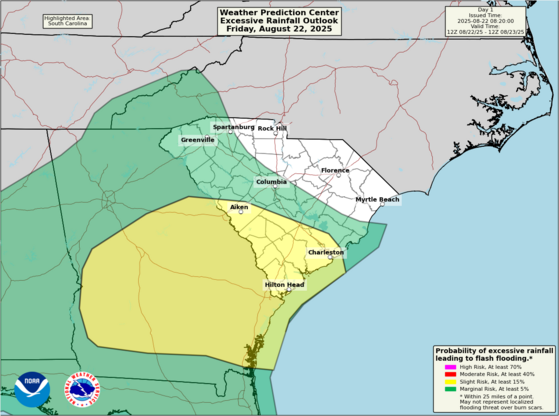
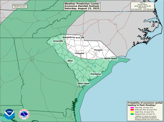
The front will remain stationary over the southern part of the state through Saturday and may cause additional soaking downpours and isolated flash flooding. Meanwhile, another cold front will arrive in the Upstate later in the day, which may also produce isolated flooding into Saturday night.
Through Saturday night, parts of the CSRA and Lowcountry may see 3-5 inches of rain from the showers and thunderstorms over the region.
The second cold front will push through the state Sunday into Sunday night with more showers and perhaps a thunderstorm here and there, but the risk for flooding downpours will be lower as the second front won’t have as much moisture to work with.
Clouds and rain will hold temperatures down Saturday with highs mostly in the lower 80s. Sunday looks a little warmer with most of the state reaching the mid-80s.
I’m pleased to report that this second front will sink south of us on Monday and deliver a nice push of cooler and less humid air. That will give us a spell of fantastic weather for much of next week. With sunshine returning on Monday, it will get warmer with highs of 85-90° across the state, and the dry air will just be starting to filter in, so the humidity will remain at typical levels. You’ll really notice improvements for Tuesday and Wednesday with highs only in the lower to middle 80s and the humidity much lower. Thursday is likely to be pleasant as well with some sunshine and low humidity. Models differ on the end of the week, with some showing a new cold front moving in and tapping into some moisture, while others keep Friday nice but show moisture returning next weekend. So, it’s too early to make any promises past Thursday. However, you’ll get to enjoy at least a few days of nice weather next week, an even better taste of fall than we had earlier in the month.


