
By Frank Strait
Severe Weather Liaison
S.C. State Climate Office
S.C. Department of Natural Resources
Key Points:
* A tropical cyclone will likely form over the northwestern Caribbean Sea in the next 24-48 hours and then track generally northward over the Gulf of Mexico before making landfall over the eastern Florida Panhandle on its way toward South Carolina.
* There is uncertainty about intensity, track, and timing since the storm hasn’t formed yet. However, it’s likely to be a hurricane at landfall in Florida and may be a major hurricane. After that, it’s likely to bring tropical storm conditions to parts of South Carolina later Thursday through Friday.
* Strong wind, heavy rain and flooding, coastal storm surge, and isolated tornadoes will all be risks for some or all of our state at the end of the week.
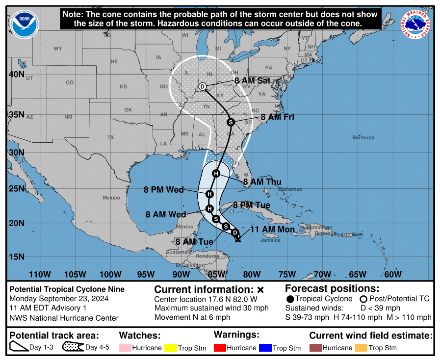
* As feared late last week, the tropics are finally coming alive again. We have two features to monitor for potential development this week, though one is over the eastern Atlantic, will take days to organize, and likely will stay far from South Carolina. Our real concern this morning is over the western Caribbean Sea. This is the area we were worried about late last week for possible impacts in the Southeast. Meet Potential Tropical Cyclone Nine; the National Hurricane Center (NHC) just issued its first advisory.
As feared late last week, the tropics are finally coming alive again. We have two features to monitor for potential development this week, though one is over the eastern Atlantic, will take days to organize, and likely will stay far from South Carolina. Our real concern this morning is over the western Caribbean Sea. This is the area we were worried about late last week for possible impacts in the Southeast. Meet Potential Tropical Cyclone Nine; the National Hurricane Center (NHC) just issued its first advisory.
At this early stage in the game, we have to talk in terms of “most likely” rather than details because there is more uncertainty in dealing with tropical features that haven’t developed yet (as we saw with the storm off our coast last week called Potential Tropical Cyclone Eight). However, we have enough consensus among computer model forecasts to say that South Carolina will see effects and that they have the potential to be significant.
Here’s the breakdown:
Wind:
The strength of the winds we see in South Carolina will depend on how strong the storm gets before moving into Florida and the storm’s track. Another concern is that this will be an XL-sized storm that could cause strong wind well away from its center. Also, it will be moving relatively fast after landfall, which increases our wind risk because the storm will have less time to weaken over land before affecting us. The forecast track from NHC puts the Lowcountry, Central Savannah River Area, and Upstate most at risk for seeing sustained tropical storm force wind. A track to the west would reduce the potential wind impacts, while one more to the east would bring a risk of damaging wind to more of the Palmetto State.
Rain:
While most of the state needs rain, tropical cyclones cause extreme rainfall rates. So, despite drought conditions, we will likely see flash flooding where the heaviest rain occurs. The heavy rain risk looks greatest in the Upstate for now, and several inches of rain may fall on the area northwest of I-85. There may also be river flooding in the Upstate. The rest of the state will see less rain, though potentially enough for isolated flash flooding. If the NHC forecast works out, the rain comes on Thursday night and Friday.
Storm Surge:
The storm surge risk is low for the most likely track, as illustrated by the NHC forecast. However, a small surge of 1-3 feet is possible. It looks like our coastal areas will have a prolonged period of gusty onshore winds from later Thursday through Friday morning, so the high tides during that period may cause coastal flooding.
Tornado Risk:
Tropical cyclones bring a risk for tornadoes for areas to the right of the center’s path. That will put most of the state at risk of seeing isolated tornadoes on the NHC forecast track. It looks like coastal areas will see the most tornado-favorable conditions.
Bottom Line:
It’s time to prepare for a big storm, and you have until Thursday afternoon to prepare. Though areas toward the Savannah River are at greatest risk, damaging winds, flooding rain, and isolated tornadoes are a risk for the entire state. It’s time to make a plan and have the supplies you need. As always, SCEMD has hurricane.sc to help you get ready.