By Frank Strait
Severe Weather Liaison
S.C. State Climate Office
S.C. Department of Natural Resources
This weekend is looking mostly quiet but next week will be more active. A moisture-starved cold front will move through tonight and deliver a breezy period tonight followed by another chilly Canadian air mass for this weekend. Temperatures will run 5-8 degrees below average; that’s not great because we’re in the coldest time of the year. A high pressure area overhead keeps it mainly sunny for Saturday, but clouds will increase on Sunday ahead of the next storm system approaching.

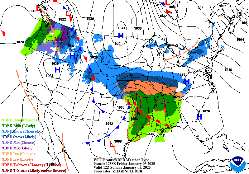
Sunday morning’s weather map from the Weather Prediction Center shows a storm over the southern Plains states tracking toward the East Coast.
Some light rain could reach the Upstate before nightfall on Sunday, but our wet period from this storm system will come Sunday night into Monday. Other than the rain, we’ll have two minor concerns. First, areas well northwest of I-85 bordering the land of tomato and vinegar sauce could be cold enough for a bit of freezing rain Sunday night and early Monday. The other concern is that a surge of lukewarm air ahead of the storm may bring thunderstorms to parts of the Coastal Plain on Monday. However, severe weather looks unlikely.
Tuesday through Thursday look rather cold and dry. Highs will be in the 40s across the state with lows in the 20s; colder spots across the north will dip into the teens on Wednesday and Thursday morning. A breeze on Tuesday and Wednesday will make it feel even more frigid. Sunshine will have limited value on Tuesday and Wednesday, then clouds will increase on Thursday as another storm approaches.
By now, you probably have noticed a buzz on social media about the potential for a winter storm around a week from today as fresh cold air arrives from Canada around the same time a storm moves through the southern tier of states. As with all potential events a week away, there is a lot of uncertainty; the difference is that the event could be impactful.
Model watching can be fun (like the GFS throwing a ‘granddaddy of them all’ snowstorm at us on a recent run that disappeared on the following run) but that has little more than entertainment value at the range of a week or more. It’ll be a few more days before we have a good idea of how the late-week storm will affect the Palmetto State. The weather pattern is indeed the best we’ve seen in a while (snow-loving weather geeks have been salivating over the combo of a negative North Atlantic Oscillation and positive Pacific-North American Teleconnection for a while). However, not all favorable weather patterns bear wintry fruit. Storms and cold air must dance together in just the right way to cause a winter storm in South Carolina, and any misstep results in a cold rain or cold and dry weather instead. So, suffice it to say that we have too much uncertainty with timing, storm track, and intensity to promise anything for next Friday.
To return to the theme from last week, the ingredients are in the house and we’re still waiting for momma to turn the oven to 350° on a cold winter afternoon. What’s changed from last week is that you noticed she brought home a can of Eagle Brand and some vanilla extract this week … snow cream ingredients! Just temper your enthusiasm because that stuff has a shelf life of YEARS.
No matter what happens with the storm at the end of next week, another shot of cold air will follow, perhaps the coldest of the season. We may see another opportunity for snow and ice the following week before the weather pattern changes to a warmer one toward the end of the month. So, it’s best to be prepared. There’s still time to winterize if you haven’t yet. If you need preparation tips, SCEMD has you covered with their Severe Winter Weather Guide (https://www.scemd.org/stay-informed/publications/severe-winter-weather-guide/?utm_content=&utm_medium=email&utm_name=&utm_source=govdelivery&utm_term=).


