
By Frank Strait
Severe Weather Liaison
S.C. State Climate Office
S.C. Department of Natural Resources
Key Points:
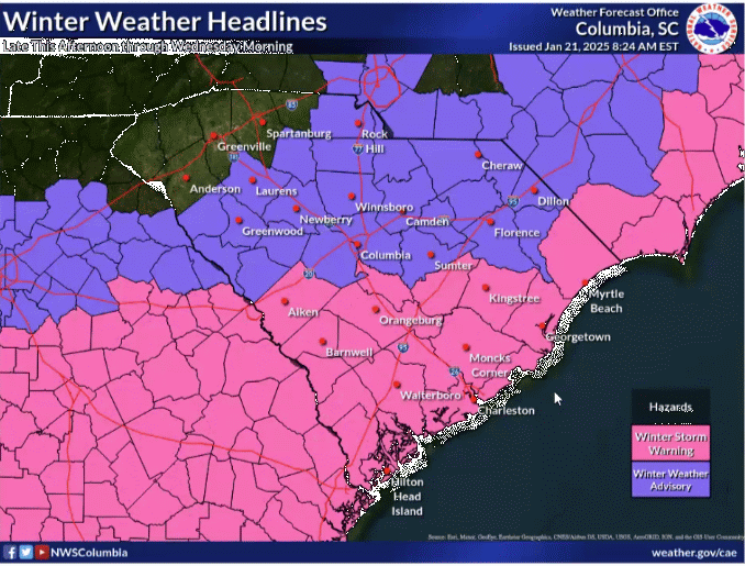
* A Winter Storm Warning or Winter Weather Advisory is in effect for all of South Carolina south of the I-85 Corridor.
* Precipitation will begin earlier than expected. Flurries are already occurring over parts of the Upstate and Central Savannah River Area. More significant snow will begin this afternoon.
* The forecast has shifted to a more impactful winter storm for South Carolina, with precipitation heavier than previously expected.
* The heaviest will still be along the Coastal Plain, though near the coast, sleet and freezing rain mixing in will limit snowfall totals.
* A gusty breeze during and just after the storm will cause some blowing and drifting of the snow where it’s heaviest.
* Precipitation will end from Upstate to coast Wednesday morning, well before daybreak in the Upstate and by around 10 a.m. along the coast.
* Roads will become hazardous over most of the state tonight and remain hazardous through Wednesday morning.
* Afternoon melting and nighttime refreezing south of I-20 results in icy secondary roads and back roads Wednesday night and Thursday morning, and potentially again Thursday night and Friday morning.
I just have a quick update to let y’all know that the forecast continues to shift as the feared flip-flop in the computer model guidance is underway, and it’s now looking like our winter storm will be worse than thought. Or better, depending on your point of view. The point is that the precipitation will be heavier than we thought yesterday.
We’re still in a state of flux, but seeing how intense the storm is this morning down in Texas and Louisiana is concerning. It’s snowing in New Orleans and even over the Gulf of Mexico, and an unprecedented blizzard warning is out for Southwest Louisiana, gasp.
We won’t see a blizzard here in South Carolina, but the storm is going to bring heavy snow to the inland part of our Coastal Plain. Areas near the coast, especially in the Lowcountry, will see sleet and freezing rain mix in to hold accumulations down. However, the water content will be the same or greater at the coast, so melting time will be about the same.
Here’s how t’s looking now for snowfall totals:
The Upstate still sees light snow this afternoon and tonight with most areas seeing a dusting to an inch; southern areas see the heaviest of the snow. The same applies to the Catawba River Area. Some roads will become slick tonight and remain slick through Wednesday morning.
Areas along I-20 are looking at generally 1-2 inches. Some spots come up a little short of an inch, while others might get slightly more. Roads will become slippery tonight and some back roads remain slick for much of Wednesday. There might be icy spots Wednesday night and early Thursday on the back roads.
Over the southern Central Savannah River Area, southern Midlands and into the inland Lowcountry, heavier snow of 2-4 inches will fall. Locally higher amounts of 5-6 inches can’t be ruled out. This also applies to the Pee Dee south of I-20 except for the coast. Roads will become slick tonight and remain slick Wednesday morning. Secondary and back roads will be icy Wednesday night and Thursday morning due to refreezing. Icy patches on the secondary and back roads are likely Thursday night and Friday morning.
Near the coast, 1-3 inches of snow will fall with sleet and freezing rain mixing in, especially over the Lowcountry. Freezing rain is unlikely to cause enough ice buildup for tree and power line damage, but will make the roads very slippery where it occurs. Roads will become slick tonight and remain slick Wednesday morning. Secondary and back roads will be icy Wednesday night and Thursday morning due to refreezing. Icy patches on the secondary and back roads are likely Thursday night and Friday morning.
Another update will be forthcoming later today once the currently incoming of computer guidance is available.
WEATHER ALERT: Changes To The Winter Storm Forecast