By Frank Strait
Severe Weather Liaison
S.C. State Climate Office
I won’t talk much about the tropics today because there isn’t much to talk about. All remains quiet on the tropical front.
Tropical waves are found along 85° west in the western Caribbean Sea, along 58° west just east of the Lesser Antilles, along 42° west over the middle of the tropical Atlantic, and south of Cabo Verde along 22° west. Only the wave over the western Caribbean is generating significant thunderstorm activity, but it’s about to move into Central America and Mexico. The wave over the middle of the Atlantic looks interesting because there is broad turning along the wave, but there are no thunderstorms around it because it’s in the middle of a region of sinking air.
Look closely at the satellite view, and you can diagnose the sinking air. To the west of that tropical wave, the usual trade winds are flowing, sending clouds westward. To the east of it, you can see clouds moving eastward, signaling a westerly wind in that area. Air is flowing out of the area containing the tropical wave, and it can only come from above.
You’ll notice an area of disturbed weather over the northwestern Gulf and a bit of a spin associated with it, but it’s going to have to act fast if it’s going to develop into a tropical cyclone. The National Hurricane Center is monitoring it, but they only give it a 10 percent chance of becoming a tropical depression or storm before it moves into Texas and Louisiana.
The quiet times in the Atlantic tropics are likely to last another week at least. Starting next weekend, however, the usual progression of the Madden-Julian Oscillation will bring more favorable conditions to the Atlantic Basin. Therefore, there’s a chance that the deep tropics will perk up, and some computer models hint at this possibility. Additionally, we are likely to see another cold front push well to the south and into the area off the Southeast Coast and northern Gulf, which tends to be an area where we see tropical shenanigans emerge, much like a magician pulling a rabbit out of a hat.
As always, these quiet times are a good opportunity to prepare for what may happen as we approach the peak of hurricane season, which begins around two weeks from now. If you need help with storm prep, hurricane.sc is the place to go.
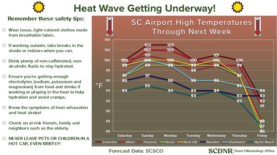
A Brutal Heat Wave Starts This Weekend
I’m not gonna lie, y’all, the coming heat is going to be hard to handle with sweltering afternoons coming a dime by the dozen this weekend and next week. Yes, we’re famous (some would say infamous) for intense heat and high humidity, but the coming heat wave will be a couple of notches above our usual sultry stretches. Here’s how I see the next week shaping up:
That looks rough because it is. If my forecast verifies, we’ll see Columbia tie its third-longest stretch of 100° days (the record is eight, set in July 1986). Ouch! Of course, the humidity compounds the problem, even though the humidity levels won’t be as high as we typically see. We’ll see the heat index peaking in the 105-110 range over most of the state Sunday through Thursday, with the usual Corridor of Heat Misery along and just south of I-20 potentially seeing a peak index over 110 Sunday and Monday.
If this isn’t enough, it’s unlikely to cool off much at night. Lows will be mainly in the 75-80° range. Yes, some places may not drop below 80° at night, and with it being humid, some may experience a minimum heat index of around 85. It’s hard to recover when it doesn’t cool off much at night. I know I don’t sleep well when it’s so warm overnight, and sleep deprivation exacerbates all other hardships.
Heat like this is nothing to take lightly, even for those acclimated to being out in the heat. Many of us become complacent about the extreme heat that we occasionally experience, and that’s how we often get into trouble. Additionally, we have thousands of newcomers who haven’t yet experienced a heat wave like the one we’ll see next week. Along with keeping an eye on yourself and your family (particularly the very young and very old), keep an eye on your neighbors who just got here from up north and just don’t know the ramifications of a lengthy heat wave like we’ll see in the coming days.
Often, we can rely on spotty afternoon thunderstorms to help with the heat, but those will be few and far between this weekend and Monday. The areas northwest of I-85 and just inland along the Coastal Plain have the best chance of seeing a downpour. Afternoon storms will mainly be absent elsewhere. It appears that we’ll see an increase in afternoon thunderstorm coverage starting Tuesday, with the same areas being favored for the most widespread thunderstorms.
While the next six days are going to be miserably hot, there is already a light at the end of this tunnel, and I promise it’s not an oncoming train. A cold front will move in at the end of next week, bringing substantial relief. The question is whether the front arrives early enough to cool us down on Thursday or whether we’ll have to wait until Friday. The northern parts of the state have the best chance of experiencing a drop in temperatures on Thursday, while the rest of the state continues to simmer. Friday might turn out to be one more hot day in the Lowcountry, depending on the speed at which the front muscles its way south. With the drop in temperatures will come more widespread thunderstorm activity, though there’s a chance that parts of the state will see cooler and less humid air push in from the north next weekend. That sure would be nice, and I’ll be rooting for it.
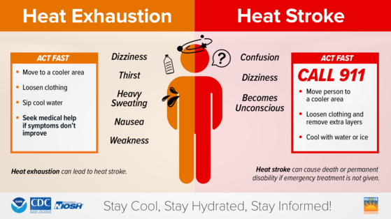
Try to stay cool, y’all. I’ll leave you with an important reminder about the symptoms of heat exhaustion and heat stroke.