By Frank Strait
Severe Weather Liaison
S.C. State Climate Office
S.C. Department of Natural Resources
Key Points:
-A Winter Storm Watch is in effect for the Lowcountry.
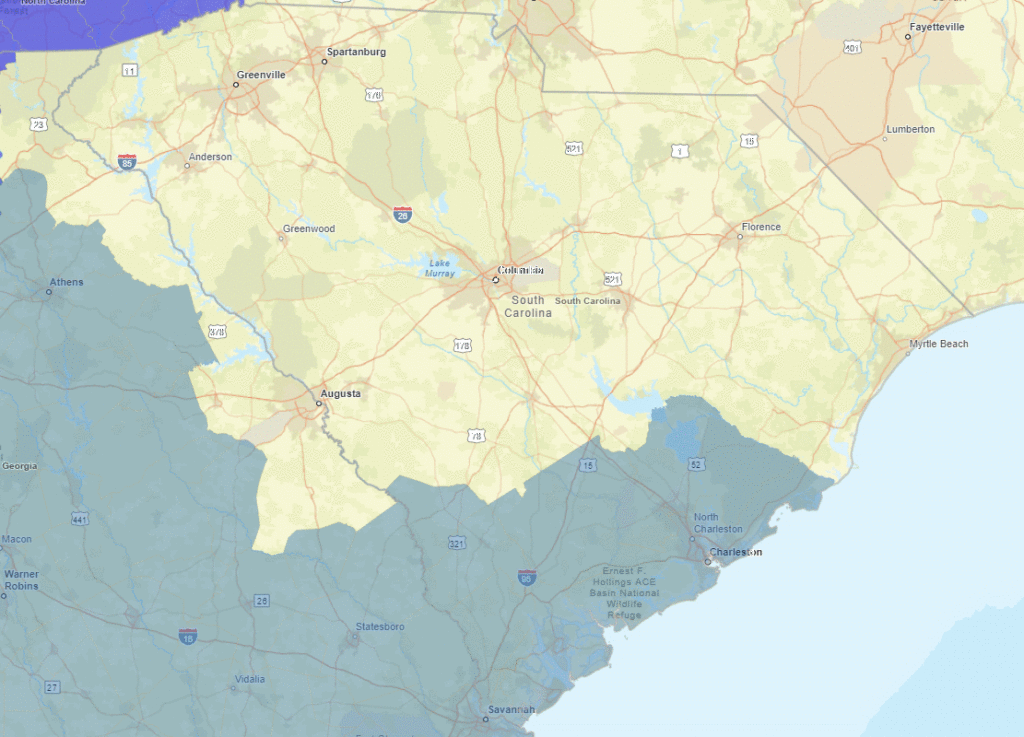
-A winter storm will affect South Carolina Tuesday night and Wednesday. The area along and south of I-20 is the primary area of concern.
-Frigid air moving in will make this primarily a snow event across the state. The area north of I-20 will likely see only light snow with less than an inch accumulating, causing slick spots on the roads.
-Along I-20 and just south, accumulations will be around an inch. Travel problems will be more significant; the roads will be slippery on Tuesday night into Wednesday, and there may be slick spots again on Wednesday night and Thursday morning.
-More significant snow is possible along the Coastal Plain. The forecast calls for 1-3 inches, but a slightly further north storm track or a slightly stronger storm than expected would bring more snow. Near the coast, snow will mix with sleet and freezing rain; the freezing rain will make the roads very slick, but tree and power line damage is unlikely. Travel will be hazardous in this area Tuesday night through Thursday morning as melting will be slow.
-There remains a chance for the storm to be a little stronger than expected, track further north, and have more moisture with it than expected. That would result in heavier snow than currently forecast.
-A second bout of winter weather is possible Thursday, mainly in the Pee Dee region. Early signs are that there will be freezing rain and sleet, and early indications are that this will be a minor event. We’re finally getting some clarity about what’s coming our way with this week’s winter storm. We have a pretty good idea about the timing of the storm. Questions remain about the storm track, intensity, and available moisture, but the trend has been toward a significant but not extreme event primarily affecting our Coastal Plain.
The players are taking the field. Arctic air is moving into the Palmetto State behind a cold front that moved through earlier today. Meanwhile, the disturbance responsible for our winter storm is moving through the Intermountain West. The cold air will be well-entrenched when it reaches us Tuesday night. I won’t spend much time discussing the cold here, except this week will likely feature the coldest days of the winter. If you need to wrap pipes, be sure you get that done Monday, as that will be your last chance.
You’ve heard the saying that it gets too cold to snow sometimes. In practice, the opposite is true; sometimes, it gets so cold that snow is the only option. However, in a cold weather pattern such as this week, storm systems can track so far south that our precipitation is either mainly along our coast or misses us entirely. One example is the Christmas 1989 winter storm that dumped heavy snow on our coast. The storm track for our coming storm will be like that, with much less moisture available.
So, this time, our Coastal Plain sees the heaviest precipitation, with lesser amounts along I-20 and north. Parts of the Upstate may miss out on the snow. Below is the latest forecast from the National Weather Service on snowfall totals.
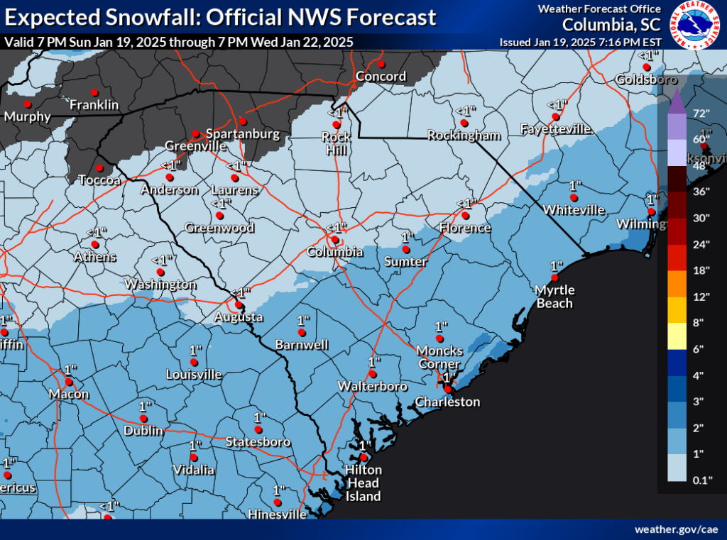
The way it looks right now, The area between I-85 and I-20 will see an inch or less of snow, which will be enough for slick spots on the roads Tuesday night and Wednesday morning. The concern for travel troubles is higher further south, where an inch or two is in the forecast.
However, here’s where the uncertainty about the storm’s strength, storm track, and available moisture comes into play. Some of our computer models show the storm a bit further north, stronger, and with more moisture in play. So, the National Weather Service also produces a ‘worst-case scenario’ forecast to show people how bad the storm could be if the more reasonable alternate scenarios work out. Here’s what that forecast looks like:
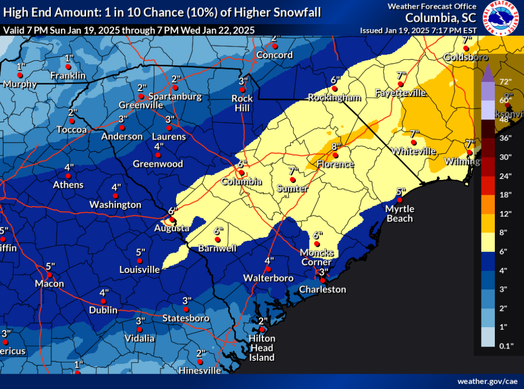
That’s a big difference! This map shows the value the NWS thinks has a 10 percent chance of being met or exceeded. Let me turn this around to make sure you understand it. There is a 90 percent chance we won’t see this much snow! The point is that there is still some risk of this being a major snowstorm for much of the state. There must be an allowance in the forecast for the storm to come a bit further north than currently expected, to be stronger, and to have more moisture to work with. Also, our computer models have been trending toward less moisture, further south, and weaker, but sometimes they take the trend too far and have to swerve back the other way. That also has to be accounted for, and that’s what you see in the map above.
Here’s what I think:This won’t be a big storm if you’re in the Upstate. Areas northwest of I-85 could miss out entirely. You might have to get your broom or blower out to clear your driveway Wednesday morning (it’ll be dry and powdery snow … not seen ’round here much), but the impacts will be minor. If you go out, you’ll have to be extremely careful because there can be slick spots. If the storm starts looking like it will come further north, you have more serious impacts. We’ll be watching, and you should have what you need in case the roads are in bad shape on Wednesday and Thursday.
Further south, along I-20 and just south, you’ll likely get more impactful snow. It’s still an inch or so, but that will cause slick roads on Wednesday. Some slick patches may still be there on Thursday morning. If the storm comes further north, the snow will be heavier, so it will hang around longer. I recommend having what you need for a couple of days at home, but things will likely return to normal on Thursday afternoon.
I’m worried about an area over the Coastal Plain’s interior, as it wouldn’t take much of a flop back to the north on the storm track or for it to be a little more potent and moisture-laden to cause a significant storm. This area should mainly escape the risk of a layer of warm air aloft moving in and causing the snow to mix with sleet and freezing rain because it’s unusually cold. So, even though an inch or two is the most likely forecast, which would only cause a day or two of problems, there’s enough risk for a more serious snowstorm that it would be best to be able to avoid travel Wednesday through Friday, should it come to that.
We’re likely to see the snow mix with sleet and freezing rain near our coast, which will hold the snow accumulation down. An inch or two of snow and sleet, maybe three in some areas, is likely. Freezing rain can lead to some ice buildup, though not enough to cause tree and power line damage. The roads could become very slick, though. While it’s very cold down here, we should be able to melt away what falls faster, especially in the Lowcountry. So, being ready to be stuck at home just Wednesday and Thursday should suffice for the coastal Lowcountry.
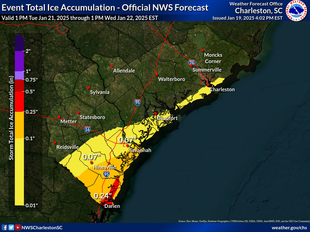
As for the post-storm weather, remember in the last edition how I mentioned we have the risk for another minor winter storm later in the week? That’s coming Thursday (a day sooner than previously expected) for areas near the coast. It won’t be as cold for this event, so we will likely see rain on the immediate coast, but there is the potential for a mix of freezing rain, sleet, and maybe snow over in the Pee Dee region. It looks like a minor event that won’t pose much risk for tree and power line damage from the ice buildup, but it may make the roads slick again into Friday morning.
Now, state and local road crews are already treating the roads to help minimize the impacts … give them room to work when you see them. And don’t forget to wash the brine off your car once the weather improves. Living up north for 20 years, I learned first-hand how corrosive it can be if you aren’t diligent about cleaning your undercarriage. So be diligent about getting your vehicle washed this coming weekend.
That should cover it. Updates will come daily since we’re in for a 1-2 punch of storms, with the first punch being the bigger bruiser. So, get ready, and check out SCEMD’s SC Severe Winter Weather Guide if you need prep advice. See you Monday!


