By Frank Strait
Severe Weather Liaison
S.C. State Climate Office
It looks like the potential for significant snow in South Carolina is diminishing. I think much of the state sees a rain-to-snow event on Sunday, but not much will accumulate.
Over the next 36 hours:
A cold front currently stretching from a storm over Michigan’s Upper Peninsula to South Texas will move through South Carolina and become stationary along the coast.
The front will cause light rain over much of the Upstate on Saturday morning. Snow or sleet may fall in the higher spots north of Highway 11, but there will be little or no accumulation.
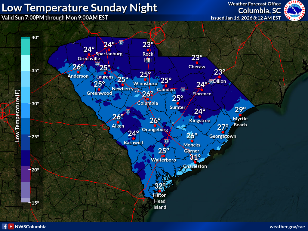
Fresh cold air will filter into the state behind the front Saturday night into Sunday.
Though our computer models have come into much better agreement on how Sunday’s storm will unfold, there remain some uncertainties:
We know the storm center will track near the Gulf Coast and the Carolina coast, but a slight shift remains possible, which would affect where the heaviest snow falls.
The models don’t look as cold as they did before, which limits how much precipitation will fall as snow. If they trend much warmer, we’ll see little or no snow anywhere in the state. We also have to watch for a flip-flop back to a colder idea.
While 2-4 inches worth of snow may fall, warm ground, marginal near-surface air temperatures, and the fact that the snow will fall during daylight mean it will be a struggle to get even an inch to accumulate where the heaviest snow falls; it melts almost as fast as it comes down.
There remain questions about the storm’s intensity and how much moisture it will be able to wring out over South Carolina. The trend has been toward a somewhat stronger, wetter storm, but most of the precipitation falls when it’s too warm for significant snow.
The models seem to be in two camps right now on where the best chance for accumulating snow is. One shows rain-to-snow mostly along the Coastal Plain, with the best opportunity for accumulations there.
While the model shows up to around an inch and a half accumulating, warm ground and marginal air temperatures should keep accumulations under an inch … even a half inch on the ground could be tough to achieve.
The other camp shows a band of accumulating snow near I-20 (with rain at the onset), with coastal areas too warm, so those areas mainly see rain and possibly flurries at the end.
Again, while the model shows 1-2 inches accumulating, marginal ground and near-surface air temperatures would keep accumulations mostly under an inch.
In both scenarios, a farther-northwest track of the storm would shift those accumulations northwestward. In doing so, it would likely lead to a more substantial accumulation where snow occurs, as such a shift would be toward colder air. The data we have available so far from the afternoon computer model cycle hint at this possibility.
Also, both scenarios would allow for light snow or flurries to the northwest of the main band of accumulations, with perhaps a thin coating here and there.
Where we do see accumulations on Sunday, a cold Sunday night would mean a risk for black ice on the roads into Monday morning. Highs near 50° around the state on Monday afternoon should melt whatever is left on the ground early Monday.
Due to uncertainties, the forecast is subject to change, so stay tuned for updates. I’ll send out another update sometime Saturday.
WEATHER ALERT: A Slushy Sunday?