By Frank Strait
Severe Weather Liaison
S.C. State Climate Office
S.C. Department of Natural Resources
A cold front is moving into South Carolina today, which is running out of momentum and will become stationary. It will remain over us or nearby for days. Storms will track through the eastern states along this front, giving us a few rounds of needed rain. These storms will pass north of us, keeping cold air mostly bottled up over the Midwest and Northeast.
The front will trigger spotty showers for the rest of today and tonight. I can’t rule out a downpour and rumble of thunder along and south of I-20, but this would be isolated. Last night was springlike and muggy; tonight will be cooler but nowhere near as cold as it can be in February.
A storm now moving through the Intermountain West will race across the country this weekend. It will cause the front to lift northward as a warm front Saturday into Saturday night. We’ll see a scattering of showers from the front, but nothing widespread. Once again, I can’t rule out a quick downpour and a rumble or two of thunder, but this is a long shot. Highs will mainly be in the 70s, except for thicker clouds keeping it mostly 60s in the Upstate, Catawba River Area, and upper Pee Dee.
The front will sink south again as the storm moves out to sea on Sunday. May-like air will surge ahead of the front, sending our temperatures into the 70s and 80s. Daily record highs will be challenged; some records will fall if it’s sunny enough. Showers return Sunday afternoon and night as the front arrives.
Some of the cold air to the north will nose in on Monday, putting us into a gray and drippy cold air damming wedge. Most of the state will only reach the 50s, with the 60s in the Central Savannah River Area and Lowcountry. The far south might get to the 70s again.
The next storm in line will move through on Tuesday, which will likely be a rainy day for the Palmetto State. The cold air wedge likely holds on across the I-20 Corridor and north, keeping highs only in the 40s and 50s. Warmer air in place further south means the area will reach the 60s, maybe low 70s, resulting in a chance for thunderstorms.
Wednesday looks unsettled with the stationary front lingering over us. Another storm will move through Wednesday night or Thursday; the timing is uncertain. That storm will track farther north, so warmer air will surge in, bringing a better chance for thunderstorms. We’ll have to evaluate the risk for severe storms later; we have too many variables now.
After that storm moves through, we get a break from the wet weather for a couple of days as cooler air moves in, but another storm will affect the eastern states next weekend, likely dragging another cold front through South Carolina next Sunday.
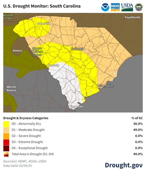
It’s good that we have several good chances for rain over the next 7-10 days because the continued lack of rain over the last week means that drought has expanded across our state.
The next update coming out Tuesday will likely show a further worsening of the drought, but substantial rain coming Tuesday and beyond will bring some improvements. The Upstate is likely to see the heaviest rain next week, but we should also be able to put a dent in the drought in other areas.