By Frank Strait
Severe Weather Liaison
S.C. State Climate Office
S.C. Department of Natural Resources
Nobody’s happier than me to report that there isn’t much weather to discuss over the next week. We have entered a warm weather pattern, which is here to stay for a while.
Today, warmth will surge northward through the Palmetto State and send temperatures well into the 70s over most of the state. Clouds and late-arriving rain hold much of the Upstate in the 60s, and the wind coming over chilly Atlantic waters will also keep coastal areas cooler. Speaking of wind, it will get blustery across the state with gusts over 30 mph, much to the chagrin of motorists and pickleball players. I’ll suggest that the leader of my pickleball group add “Yackety Sax” to tonight’s background music playlist (assuming the rain holds off).
The wind and rain come from a cold front approaching from the west. A band of showers will cross the state from west to east tonight. The rain should all be offshore by daybreak on Saturday. Y’all might hear a rumble of thunder, and wind gusts with any storm can sway the trees a little, but the severe weather risk is essentially zero.
Over the weekend, we’ll be under the influence of an area of high pressure; its center is over the Canadian Prairies today and it will track over the Great Lakes and Northeast this weekend. This air mass isn’t all that cold, and we’ll be on the fringe of it, so our temperatures only fall from today’s far above-normal readings to 5-10 degrees above normal for the weekend. Highs this weekend will mainly be in the 60s across the state, with lows mainly in the 40s. Sunshine will be plentiful on both days.
Springlike warmth will return early next week. Most of the state will return to the 70s on Monday and it will remain warm through Thursday. It wouldn’t surprise me if some of the usually warmer areas touch 80° once or twice next week. Monday and Tuesday both look mostly sunny, but some moisture may get involved as early as Wednesday.
A storm will pass by far to our north later next week. A warm front ahead of the storm will lift through this part of the country sometime later Wednesday into Thursday, and then a cold front will follow at the end of the week. As usual, there are questions about the storm’s track and timing at this range. We might see the warm front’s rain pass by to our north, but a little rain might affect the Upstate. The cold front will likely arrive next Friday, bringing a better chance for rain across the state.
Early signs are that the front could become stationary over us or nearby next weekend, so there’s a good chance that next weekend’s weather won’t be as nice as what we will enjoy this weekend.
One problem with warm and dry conditions is that we’re already behind on rainfall through December and January, so drought conditions have returned to parts of South Carolina.
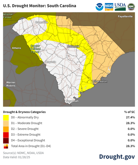
The U. S. Drought Monitor from Tuesday indicates that drought conditions cover about a fourth of the Palmetto State. So, we’re at the point where much of the state needs rain. The rain we get tonight won’t help much. The chances we have for rain next week aren’t great, either. The one benefit of possibly having a stationary front over us next weekend is a better chance for drought relief.
WEATHER: A Warm Week Ahead, Mostly Tranquil