By Frank Strait
Severe Weather Liaison
S.C. State Climate Office
We need some rain, y’all. While parts of the Upstate have only slightly below normal rainfall over the last eight weeks, but the rain-free days have been bone-dry and often windy. Also, the tree debris left behind by Helene is a fuel source, so conditions have at times favored the rapid spread of wildfires in the region. Our neighbors in Georgia and North Carolina are suffering from the same conditions. Elsewhere in South Carolina, the rainfall deficit increases as you head toward the coast, with sections of Charleston, Berkeley, and Georgetown Counties receiving less than half of normal rainfall since late January. Parts of the Central Savannah River Area also have a significant rainfall deficit.
There is good and bad news: the good news is that we have a few prospects for rain over the next week, and the bad news is that some might come from severe thunderstorms.
In the short term, dry and breezy conditions continue, and the wildfire risk remains high in the Upstate for the rest of today and tonight and elevated elsewhere in the state. If you haven’t heard, there is a statewide ban on outdoor burning right now, and you’ll need to be cautious to avoid accidentally starting a fire.
We remain mainly rain-free through Saturday, but humidity will increase as a storm system currently over Texas approaches. Clouds will also increase during the day. Highs will mostly be in the upper 70s and lower 80s. A few showers will affect the Upstate Saturday night, while it remains mainly dry elsewhere in South Carolina.
Sunday looks mainly cloudy and showery over most of the state, with the showers most widespread during the afternoon and evening. Some places will get a heavier thunderstorm with a soaking downpour, but don’t expect any miracles. Rainfall for most places will only be 0.10 to 0.25 inch, with locally higher amounts. Upsloping winds northwest of I-85 should help squeeze out more rain there. Despite the chances of rain, it looks like another warm day with highs mostly 75-80.It could be a little warmer if there’s more sun than expected.
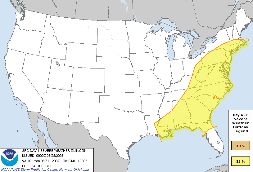
Monday brings another chance for rain as a cold front moves through, but it will be in the form of potentially severe thunderstorms. The cold front’s thunderstorms will have ample fuel (warmth and humidity) to work with, and enough wind shear will also be present for an isolated tornado threat. So, the Storm Prediction Center has all of South Carolina and most of the rest of the Eastern Seaboard and Gulf Coast outlined with a severe storm risk in their outlook for Monday. Highs Monday will range from the middle 70s in the Upstate to the low 80s in the inland Coastal Plain, and you’ll notice some humidity, a warning of what’s coming as the hot season approaches.
Rainfall amounts are always tricky with thunderstorms, especially a few days out. The Upstate could do well on Monday with a chance for over an inch; it sure would be nice to put an inch of rain down on the Table Rock and Persimmon Ridge Fires, and I hope that happens. The rest of the state will see more spotty rains from a broken line of thunderstorms. Some places will see good rain while others miss out.
We can look forward to a cooler and less humid day on Tuesday (no foolin’). The Upstate will be bone-dry, but for now, it’s not looking too windy. Hopefully, we see enough rain on Sunday into Monday that the wildfire risk stays low.
The forecast gets uncertain starting Wednesday. It looks warm and unsettled, but there is low confidence in the timing of weather features moving through this part of the country during this time. Our Monday cold front will retreat northward as a warm front sometime Wednesday into Thursday, which gives us a chance for showers. Then we’ll have another cold front move next Friday into Saturday with showers and thunderstorms (maybe even intense storms). Most of the state will see highs in the 70s on Wednesday; then, it looks like we’ll mostly be in the 80s on Thursday and Friday. Warmer spots might even reach the middle to upper 80s later next week!
WEATHER ALERT: The Silver Lining Of Cumulonimbus