

FROM THE SC CLIMATOLOGY OFFICE
By Frank Strait
Severe Weather Liaison
S.C. State Climate Office
S.C. Department of Natural Resources
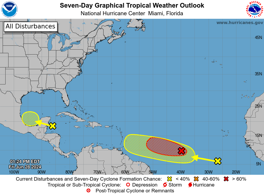
The tropics are turning active, and we have four separate features to track in the Atlantic tropics today. Three of them may become tropical cyclones over the next week. Here’s the National Hurricane Center’s (NHC’s) outlook:

Here is NHC’s Seven Day Graphical Tropical Weather Outlook from 2 p.m. Friday, showing three areas of concern for development in the Atlantic Basin.
And here’s your obligatory satellite view of the Atlantic basin today:

across the Atlantic Basin today.
Imagery Source: University of Wisconsin RealEarth
I’ll address each feature of interest separately.
Invest AL94:
This tropical wave is generating a lot of thunderstorm activity over the northwestern Caribbean Sea, but it’s dealing with vertical shear due to westerly winds aloft. It will continue to track to the west-northwest this weekend over the Yucatan Peninsula and into the Bay of Campeche as it becomes entangled with a Central American Gyre. The gyre feature will steer AL94 into Mexico. It has a good chance of becoming a tropical cyclone as it moves through the Bay of Campeche, but it will not pass anywhere near South Carolina.
Tropical Wave Near 60° West:
This wave is nearly devoid of shower and thunderstorm activity and is about to pass through a hostile environment with a ton of vertical shear from strong westerly winds aloft. There is zero chance for development of it in the short term, and no model shows any risk of development from it before it reaches Central America.
Invest AL95:
NHC essentially says that this feature is on the verge of becoming a tropical cyclone by giving it a 90 percent chance to develop. It presents well on satellite imagery with banding structures taking shape, no sign of vertical shear, and cirrus clouds expanding outward radially from the thunderstorms.
Assuming it does become a tropical cyclone soon, a track into the Caribbean Sea early next week is nearly certain. Computer model guidance takes this feature into the western Caribbean around the middle of next week, but there is some spread in the forecast tracks. It’s too soon to say whether it will end up over Cuba in about a week with a chance to affect South Carolina after that, or a farther south track results in it tracking into Central America, Mexico, or Texas. The latter scenario appears more likely right now, but we’ll have to keep a close watch on it.
East Atlantic Tropical Wave:
This feature is in an unfavorable area for development currently. It’s too far south, at only 5-10° north latitude, and there is a lot of dry air to its north. However, it will eventually gain latitude and move into a less stable air mass, so it could develop further once it approaches the Lesser Antilles. That won’t happen until next week, so there is plenty of time to watch it. Some computer models indicate that it will develop, but it may remain too close to AL95 to gain much strength. However, a more northward track appears likely, so there is some chance (I’ll have to say a low chance at this range) for it to affect South Carolina in 10 days or so.
The next few names on this year’s list are Beryl, Chris, and Debby. Hopefully, we won’t need to use them all in the next week or so. More disturbances are lining up over Africa, so we’ll need to stay vigilant and make sure we’re prepping as we should. If you need help with storm prep tips, the experts at SCEMD have hurricane.sc for you.
The extreme heat we dealt with earlier this week is on hiatus thanks to a cold front (that’s the meteorologically correct term, realistically it’s a ‘not as hot front’) that moved through yesterday. I’m sure you’re as pleased as I am that we’ve escaped from Satan’s living room. The hottest reading I saw from our official stations was 106° on Wednesday at USC’s weather station. This is the same one that recorded the statewide record high back in June 2012 (at 113°), so it’s a known hot spot.
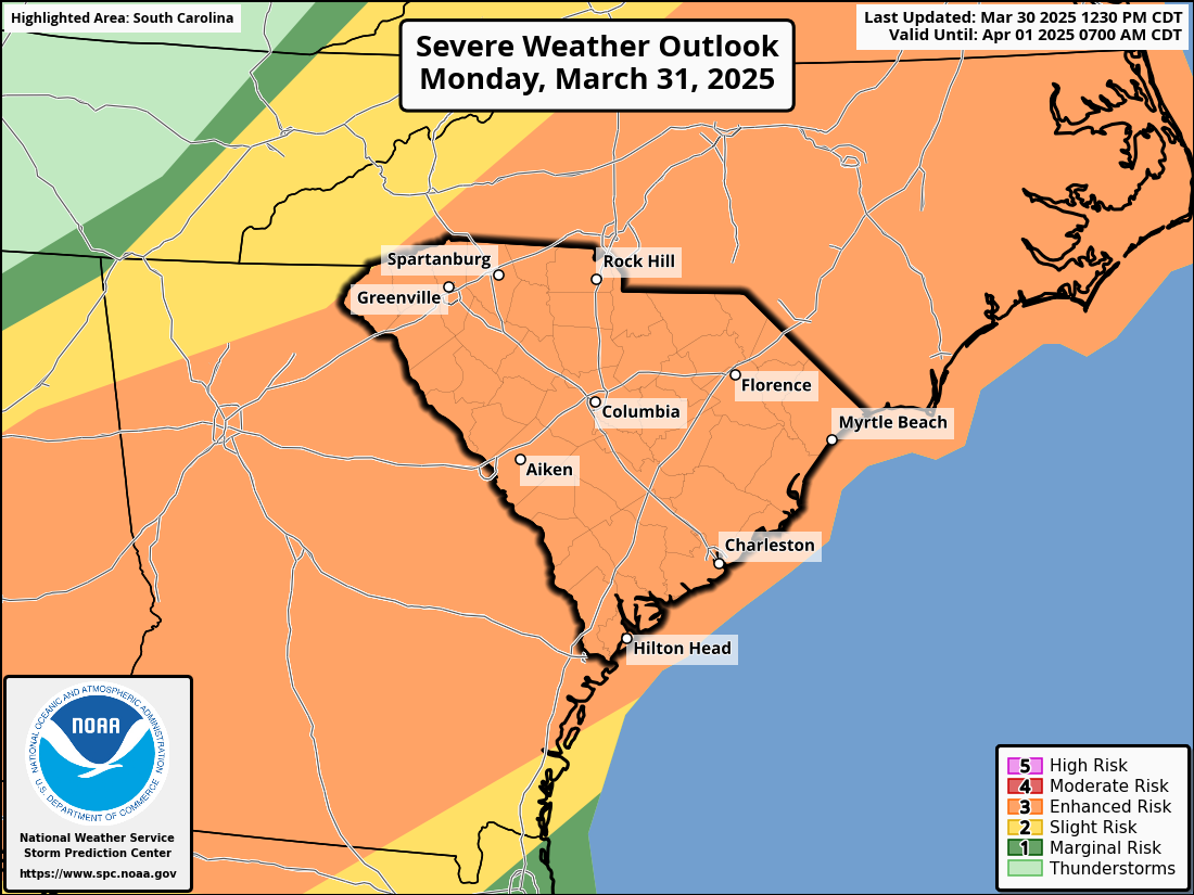
This is not to say that our weather over the next week will be anything resembling cool. Look for seasonable highs in the 90s across the state on Saturday and Sunday except for the beaches and our higher spots in the northwest. Saturday afternoon will bring the typical scattering of afternoon thunderstorms, then look for thunderstorms to become more widespread on Sunday as another cold front moves in. A swampy air mass will be in place ahead of the front, meaning plenty of thunderstorm fuel will be available. So, we have a risk for isolated severe storms later Sunday and Sunday night. The Storm Prediction Center has nearly all of South Carolina in a level 1 of 5 severe storm risk for Sunday and Sunday night due to the potential for isolated damaging wind and hail.

with South Carolina highlighted.
The front will slowly push into South Carolina Sunday night into Monday and then become stationary over our coastal areas and Georgia on Tuesday. It will then fizzle away.
With the front in the area, Monday will likely be active over most of the state. Some or all the Upstate could be spared and wind up with a nice day, but the rest of the state should see good coverage of showers and thunderstorms, which might be locally heavy and gusty. Then Tuesday brings more scattered afternoon showers and storms to the Lowcountry, with the rest of the state rain-free with lower humidity, resulting in generally pleasant early July weather. By Wednesday, the remains of the front will likely be lined up along the Savannah basin, triggering stray afternoon showers and thunderstorms. The rain is needed, badly. The last 6-8 weeks have been somewhere between dry and arid across the state and nearly half the state is in drought now. The rain may not put much of a dent in the drought but we’ll take what we can get.

High temperatures should mainly be in the 80s on Monday thanks to widespread clouds and rain, then more seasonable upper 80s and lower 90s are likely for Tuesday and Wednesday. That’s not cool, but it beats temperatures above 100°!
Unfortunately, the trend will be toward more dry and hot weather later next week. Bearably hot lower to middle 90s look likely for highs on Independence Day, but few places (if any) will have a thunderstorm to interfere with fireworks and other festivities. After that, we may be in for another spell of 95-100° readings next Friday through next weekend. The usual infamously hot spots along I-20 might get even hotter, but I hope not. Afternoon thunderstorms during this time will be few and far between, but there is a chance for an influx of tropical moisture from one of the critters over the Atlantic starting next weekend that could blunt the heat.