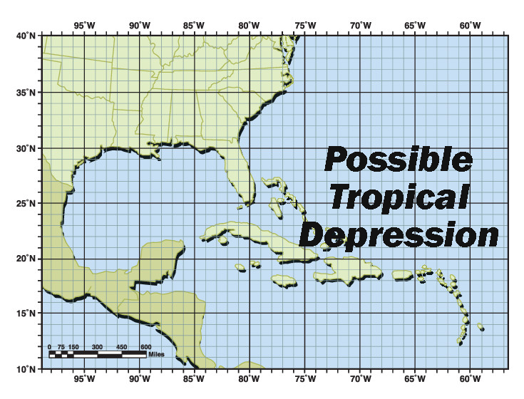
WASHINGTON — FEMA is monitoring closely a potential tropical depression over the Straits of Florida or eastern Gulf of Mexico near the Florida Peninsula. A Tropical Storm Watch is now in effect for the Florida Keys and for the west coast of the Florida peninsula.
This system has a high chance of further development. The National Hurricane Center predicts this system is likely to bring flash flooding to areas across Florida through the weekend. As the system moves north, it may bring flooding and other hazardous conditions to portions of Georgia, South Carolina and North Carolina. Residents in the path of the storm should expect heavy rainfall over the weekend and into next week.
FEMA is ready to respond and to meet any needs the state may have with personnel already in Florida supporting areas affected by severe storms, straight-line winds and tornadoes that impacted the area in May. A FEMA distribution center located in Atlanta is fully stocked and ready to mobilize commodities if requested to support state response efforts. FEMA Region 4’s Incident Management Assistance Team will arrive at the Florida emergency operations center in Tallahassee on Saturday.
FEMA encourages individuals in potentially affected areas to pay close attention to weather forecasts, heed the advice of local officials and follow these tips to stay safe during flooding:
–Be prepared for the hazards the storm may bring. This storm may bring rainfall, coastal and flash flooding and wind far from the center track of the storm along the coast of Florida. As the storm travels inland, it may bring heavy rainfall to areas in Florida and along the southeast coast from Georgia to North Carolina into next week.
–Have a plan. Know how you will keep yourself, your family and your pets safe if flooding is forecast for your area. Make sure you consider your family’s unique needs, including anyone who needs medicine or medical equipment. Know how you’ll contact one another and reconnect if you aren’t together when flooding starts. Visit.Ready.gov or Listo.gov for more information on how to stay safe before, during and after floods.
–Stay safe during flooding. Do not walk, swim or drive through flood waters. Turn Around, Don’t Drown! Remember, just 6 inches of moving water can knock you down and one foot of moving water can sweep your vehicle away. Stay off bridges over fast-moving water and never drive around barricades, local responders use them to safely direct traffic out of flooded areas.
–Be in the know to evacuate safely. Evacuate immediately, if told to do so. To plan for evacuation, it’s important to know your risks, know what to bring, know when and where to go and know trusted information sources.
–Keep important documents safe. Having your financial and medical records and important contact information will be crucial to help you start the recovery process quickly. Keep important documents in a waterproof container on a high shelf or upper level of your home. Create password-protected digital copies and move valuables to higher levels.
Other Important Tips:
Flooding can affect power systems, as utility companies may shut down portion of the electrical grid. If the power goes out, use only flashlights or battery-powered lanterns for emergency lighting. NEVER use candles during a blackout or power outage due to extreme risk of fire.
Use generators safely – always use them outdoors and at least 20 feet from windows, doors and attached garages. Make sure to keep the generator dry and protected from rain or flooding.
Learn more ways to stay safe before, during and after flooding at Ready.gov/floods and Inundaciones | Ready.gov.
FEMA Urges Residents and Visitors to Prepare Ahead of Potential Tropical Depression Expected This Weekend


