Key Points:
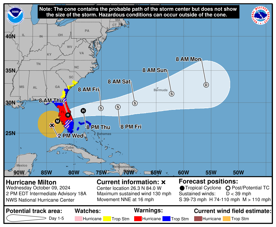
* A Tropical Storm Watch remains in effect for the coastal Lowcountry counties, from the Savannah River to the South Santee River. A Tropical Storm Warning is in effect south of the Savannah River, and travel into Georgia and Florida tonight and Thursday is strongly discouraged.
* Milton will cause widespread damage in Florida through Thursday, but South Carolina will only see fringe effects from the storm.
* Peak wind gusts in South Carolina will reach 35-40 mph in the Lowcountry and 30-35 mph across the Central Savannah River Area, Midlands, and Pee Dee regions, with less wind elsewhere. Wind of this strength would not typically cause concern for damage, but trees weakened by Helene may come down Thursday. Isolated power outages may occur.
* Minor to moderate coastal flooding is likely along the Lowcountry coast around Thursday * afternoon’s high tide.
* Little rain will fall due to Milton; what rain does fall will be near the coast in the Lowcountry.
* There is no tornado risk from Milton.
The forecast for Milton and the expected impacts have changed little from Tuesday. Milton is currently a Category 4 hurricane over the Gulf of Mexico, bearing down on the Florida Peninsula, where landfall will occur this evening. We’ll keep them in our thoughts, and I encourage y’all to help with the recovery they face as you are able and see fit.
We will only see fringe effects from Milton in South Carolina. Only two of the four threats a tropical cyclone can generate are even a low-end concern for us.
The first is from wind. Milton’s wind field is expanding because it is starting to turn from a tropical cyclone to an extratropical storm (the sort of storm we typically see in the midlatitudes). The expansion is most pronounced on the north side of the storm where we are, because an area of high pressure is over the Great Lakes. This high pressure area north of us results in a steeper pressure gradient (difference in barometric pressure) between it and Milton. So, it will be breezy to blustery across the Palmetto State after midnight tonight through Thursday. The strongest winds will be found across the Lowcountry, since it’s closest to Milton. Peak gusts in this area will be in the 35-40 mph range. Peak gusts will reach 30-35 mph across the Central Savannah River Area, Midlands, and Pee Dee. Winds mainly will remain below 30 mph elsewhere.
Ordinarily, this wouldn’t be much of a concern except for motorists, but thanks to Helene, many trees are in a weakened state and at risk of coming down from less wind than usual. That might end up in a few isolated power outages here and there. Keep away from trees leaning on other trees when it’s windy; they’re dangerous because the wind might blow them down. My dad up in North Carolina calls them ‘suck-egg trees’ for this reason, and I have the privilege of helping him deal with a few on my parents’ property on Saturday.
In addition to the wind concern for the coastal Lowcountry, coastal water levels will run above the astronomical tides Thursday. That will lead to coastal flooding around the afternoon high tide. It’s no worse than a king tide situation thanks to low astronomical tides; the first quarter moon is Thursday, and thank goodness this isn’t happening at a full or new moon. Be prepared for flooding in the usual suspect areas for a couple of hours either side of high tide tomorrow afternoon, and some road closures may be necessary, including in Charleston and vicinity.
The forecast has trended drier for South Carolina. Very little rain will fall from Milton, if any; what does fall will be along the immediate coast of the Lowcountry. So, there’s no freshwater flooding concern (aside from the lingering river flooding from Helene’s rain). Also, the tornado threat will be zero Thursday.
We’re escaping Milton’s worst, but we still have about seven weeks of the hurricane season left, so stay prepared. If you need prep advice, they leave the light on for y’all over at hurricane.sc.
Blustery Thursday Thanks To Milton


