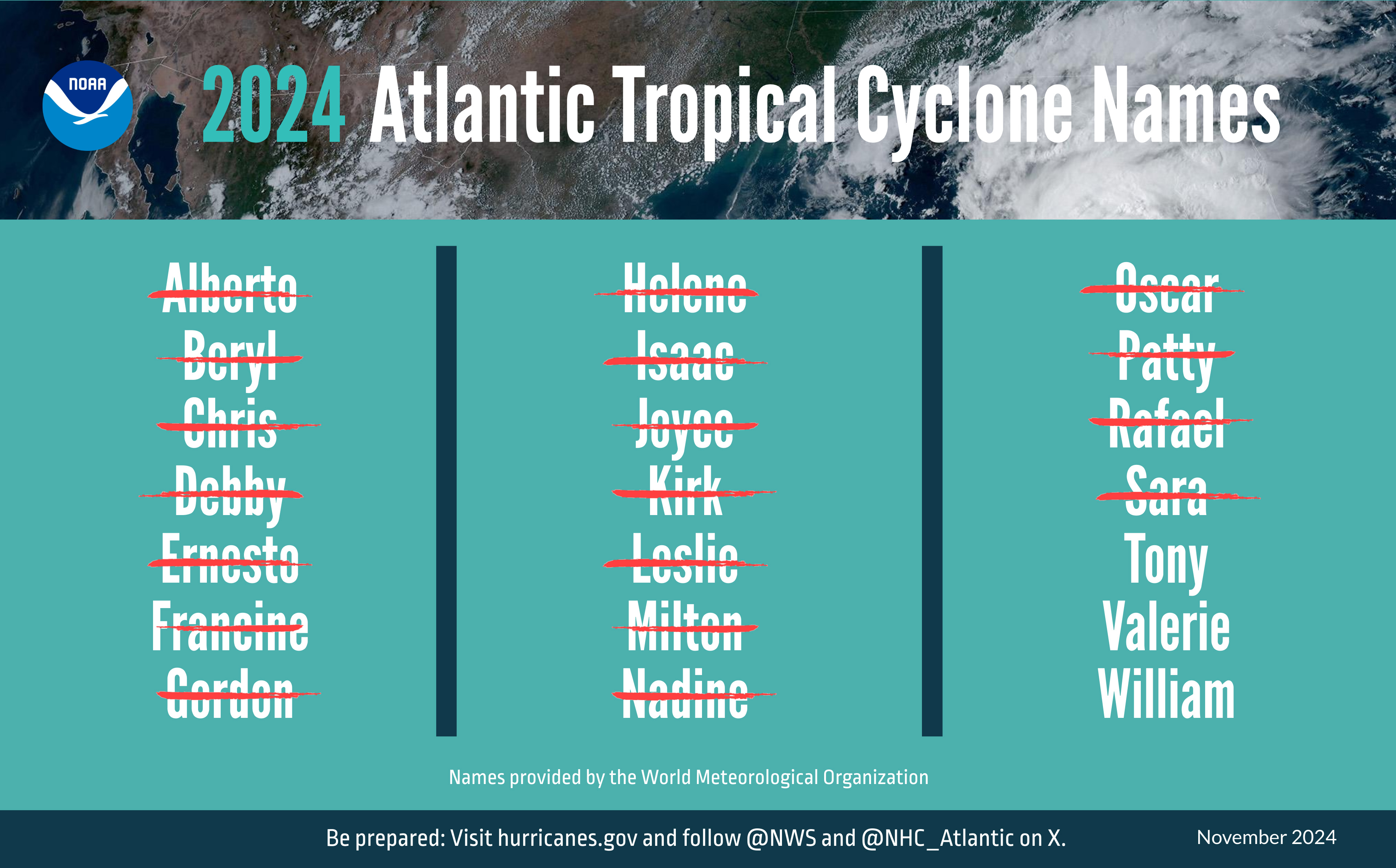
The 2024 Atlantic hurricane season, which officially ended on Nov. 30, showcased above-average activity, with a record-breaking ramp up following a peak-season lull.
The Atlantic basin saw 18 named storms in 2024 (winds of 39 mph or greater). Eleven of those were hurricanes (winds of 74 mph or greater) and five intensified to major hurricanes (winds of 111 mph or greater). Five hurricanes made landfall in the continental U.S., with two storms making landfall as major hurricanes. The Atlantic seasonal activity fell within the predicted ranges for named storms and hurricanes issued by NOAA’s Climate Prediction Center in the 2024 August Hurricane Season Outlook. An average season produces 14 named storms, seven hurricanes and three major hurricanes.
“As hurricanes and tropical cyclones continue to unleash deadly and destructive forces, it’s clear that NOAA’s critical science and services are needed more than ever by communities, decision makers and emergency planners,” said NOAA Administrator, Rick Spinrad, Ph.D. “I could not be more proud of the contributions of our scientists, forecasters, surveyors, hurricane hunter pilots and their crews for the vital role they play in helping to safeguard lives and property.”
Twelve named storms formed after the climatological peak of the season in early September. Seven hurricanes formed in the Atlantic since September 25 — the most on record for this period.
“The impactful and deadly 2024 hurricane season started off intensely, then relaxed a bit before roaring back,” said Matthew Rosencrans, lead hurricane forecaster at NOAA’s Climate Prediction Center, a division of NOAA’s National Weather Service. “Several possible factors contributed to the peak season lull in the Atlantic region. The particularly intense winds and rains over Western Africa created an environment that was less hospitable for storm development.”
The record-setters
Hurricane Beryl was the earliest Atlantic basin Category-5 hurricane on record. It caused significant storm surge flooding across parts of Texas and Louisiana after making landfall near Matagorda, Texas, as a Category-1 storm.
Hurricane Helene made landfall as a Category-4 storm on the Florida Gulf Coast on September 26. The storm caused catastrophic flooding across the southern Appalachians, widespread wind damage from the Gulf Coast to the North Carolina mountains and storm surge flooding along portions of western Florida. Preliminary data indicate that Helene was the deadliest hurricane to affect the continental U.S. since Katrina in 2005, with more than 150 direct fatalities, the majority of which occurred in North Carolina and South Carolina. Hurricane Helene marked the first time ever that NOAA’s National Hurricane Center (NHC) forecasted a system to become a major hurricane before it became a tropical depression or tropical storm. NWS was forecasting extreme rainfall totals and rates over western North Carolina more than 48 hours in advance.
Hurricane Milton made landfall as a Category-3 near Siesta Key, Florida, on October 9 and resulted in a tornado outbreak that produced 46 tornadoes and caused torrential rainfall and localized flooding with total rainfall amounts of 10-15 inches (and higher). Milton produced a destructive storm surge between Siesta Key, Florida, and Ft. Myers Beach, Florida, including Charlotte Harbor. Milton’s rate of rapid intensification was among the highest ever observed, with a 90-mile-per-hour increase in wind speed during the 24-hour period from early October 6 to early October 7. NHC’s first forecast for Hurricane Milton indicated the potential of a major hurricane landfall along the coast of west-central Florida almost two days before it formed into one, and more than four days prior to landfall.
The 2024 Pacific Hurricane Season
Hurricane season activity was below-normal for both the eastern Pacific basin and central Pacific basin and fell within predicted ranges, respectively.
The eastern Pacific basin hurricane season had 12 named storms, with four becoming hurricanes and three intensifying to major hurricane status. The central Pacific had two named storms.
A season of advancement
NOAA’s Hurricane Analysis and Forecast System aided NHC forecasters with improved predictions this season.
“During this active season in the Atlantic, NOAA’s National Weather Service, National Hurricane Center and NOAA Research hurricane scientists continued to advance our modeling and observation capabilities, preliminarily resulting in the most accurate NHC track forecasts ever issued at all forecast lead times in 2024,” said Michael Brennan, Ph.D., director, NOAA’s National Hurricane Center.
NHC implemented an experimental version of the cone graphic in 2024 that includes U.S. tropical storm and hurricane watches and warnings over inland areas. NHC scientists will evaluate public feedback on the usefulness of the experimental cone during the off-season months before NHC determines the future of the new cone graphic.
By the numbers: NOAA’s hurricane research and response
This season, NOAA Hurricane Hunter aircraft flew 392 mission hours to collect atmospheric data that are critical to hurricane forecasting and research. The Hurricane Hunters passed through the eye of hurricanes 80 times and deployed more than 1,246 scientific instruments.
NOAA’s Atlantic Oceanographic and Meteorological Laboratory hurricane researchers participated in 67 Hurricane Hunter missions, processing Tail Doppler Radar scans and dropsonde profiles that are critical for real-time decision making and improving forecasts. Researchers also set records while testing new technology used to study hard-to-reach areas of the storms, releasing 17 Black Swift Technologies S0 uncrewed aircraft systems and 91 Skyfora StreamSondes. NOAA Research and partners also observed the ocean throughout the season to support hurricane intensification research and forecasts, using ocean gliders, saildrones, wave buoys and drifters.
NOAA’s National Ocean Service (NOS) captured more than 26,000 aerial overflight images of areas impacted by hurricanes Debby, Francine, Helene and Milton, and their navigation response teams surveyed 316 linear nautical miles in and around impacted ports to inform their safe reopening. The NOS Integrated Ocean Observing System coordinated a hurricane ocean glider field campaign with partners to monitor and track dynamic ocean features known to influence hurricane intensity. More than 100 gliders captured ocean conditions ahead of hurricanes aimed at the U.S. coast and contributed ocean temperature data to forecasts.


