By Frank Strait
Severe Weather Liaison
S.C. State Climate Office
S.C. Department of Natural Resources
Key Points:
* The National Weather Service (NWS) has expanded the Winter Storm Warning area into the I-20 Corridor, and a Winter Weather Advisory is in effect further north.
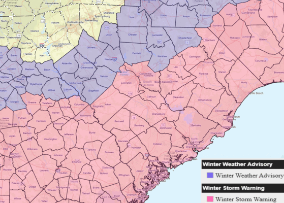
* This map shows the areas currently under a Winter Storm Warning or Winter Weather Advisory around South Carolina.
* Travel will become hazardous over most of South Carolina tonight and remain hazardous through Wednesday morning. * Roads will become slippery, and moderate-to-heavy snow over the Coastal Plain will cause poor visibility.
* Sleet and possibly freezing rain can mix in along the Lowcountry coast. Roads will be extremely slick where freezing rain occurs. There can be a minor ice buildup on trees and power lines, but we do not expect any damage.
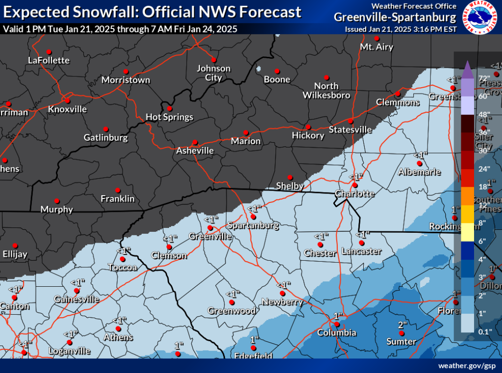
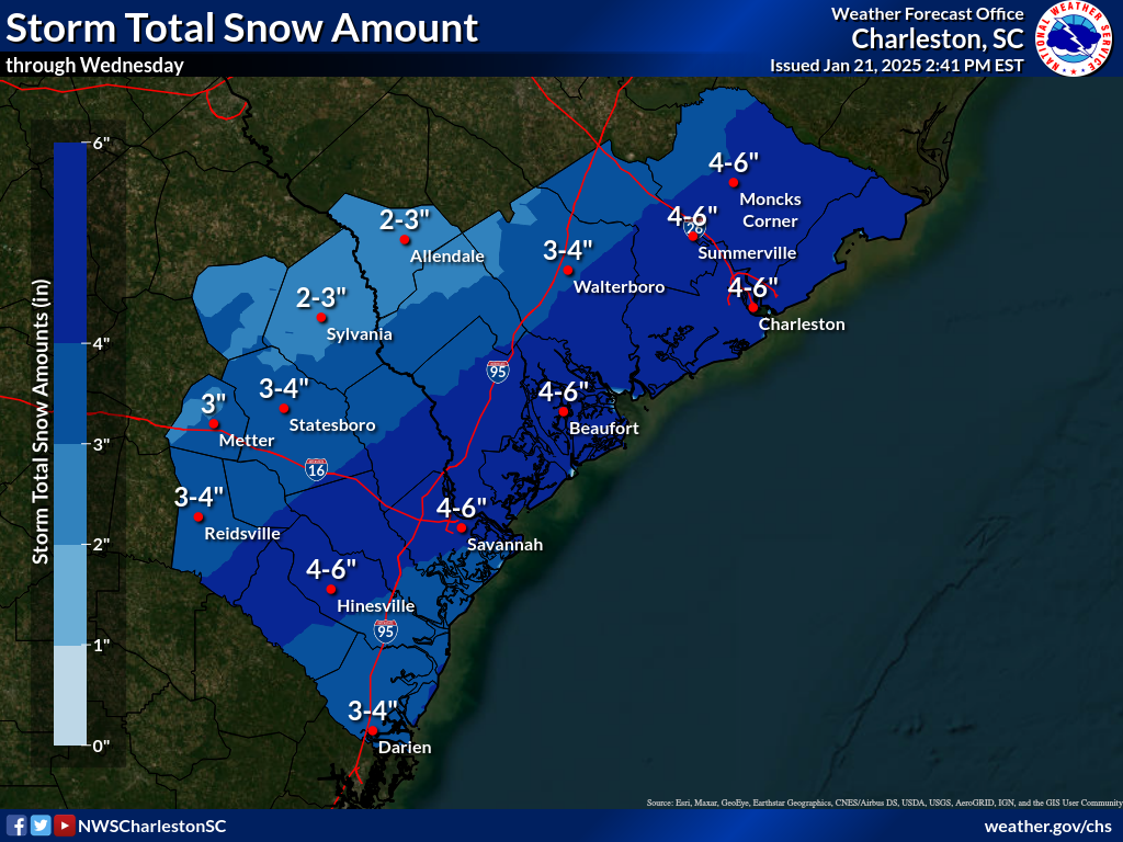
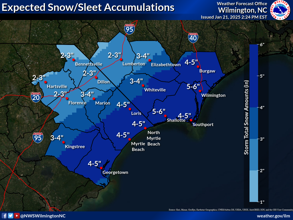
Accumulations: The heaviest snow will fall over Coastal Plain; most areas will see 3-6 inches. A few spots may hit the jackpot and score 7-8 inches.
* Mixing with sleet and perhaps freezing rain along the Lowcountry coast could limit snow totals. If it stays mainly snow, 6 inches is possible, which would be near historic amounts for the area.
1-2 inches will fall along I-20; areas just south can see 3 inches. The northern Midlands and northern Central Savannah River Area will see around an inch.
* The southern Upstate and the Catawba River Area will mostly see an inch or less.
* Along and north of I-85, light snow can leave a dusting in some areas.
* Gusty winds during the storm (averaging 10-20 mph, gusts of 25-30 mph … a bit stronger at the coast) over the * Coastal Plain will cause some blowing and drifting of the snow.
* Snow is underway over parts of the state as of late afternoon, and nearly the entire state will see snow by 8 p.m.
Precipitation will end starting around 3 a.m. Wednesday in the Upstate with the back edge of the snow working southeastward through the morning. Snow will end along the coast around 10 a.m. Wednesday.
* With temperatures rising above freezing Wednesday afternoon but dropping well below freezing Wednesday night, roads will become icy into Thursday morning along and south of I-20 due to refreezing, particularly the secondary and back roads that may not be treated by crews ahead of the storm.
* Another thaw-and-refreeze cycle is likely for secondary and back roads Thursday afternoon and night along the Coastal Plain; some roads will be icy again Friday morning. There is a chance for icy patches again Saturday morning in this area before a weekend warmup melts the last of the snow and ice.
* Bitter cold will make it difficult for those who must be outside. Wind chills tonight will drop to the single digits and teens. Highs will only be in the 30s Wednesday, and lows will mainly be in the teens Thursday morning except in the 20s along the coast.
I have returned from my time travel to the mid-1980s for this update. A Huey Lewis song is still running through my head, and I miss ’80s hairstyles. Sorry for the glitch this morning! I was entering the date on the composition screen for these alerts, and I was thinking about how cold it was 40 years ago today (-1°F in Columbia, and the all-time state record low of -19°F was set at Caesars Head), so the wrong signal went from my brain to my fingers.
Anyway, the trends toward more snow falling with our winter storm coming tonight and early Wednesday continue. The National Weather Service continues to raise their forecast snowfall amounts thanks to the computer models flopping back to a more serious winter storm for us (after flipping to less snow in recent days). Welcome to my life (and every other meteorologist’s) having to deal with computer models being flaky like that sometimes.
As we head into the evening, snow is already in the air here in Columbia, and it will get heavier and more widespread across the state.
Travel will become hazardous along the I-20 Corridor and south tonight and remain hazardous into Wednesday morning, with the roads slick and visibility reduced due to snow and areas of blowing snow. The storm will wind down early Wednesday, starting around 3 a.m. in the Upstate and ending late morning along the coast.
The forecast snow amounts along the Coastal Plain will make it difficult to get around for at least a couple of days unless you’re near a major road or in a city. SCDOT and local road crews will be able to get the interstates and other major roads passable by Wednesday afternoon, but the secondary and back roads will be a different story. Those roads will stay hazardous all day Wednesday and be icy Wednesday night and early Thursday. You might be able to get out on Thursday afternoon if you must, but the back roads will probably be slushy. Another refreeze is likely Thursday night into Friday morning. Things improve more on Friday as it warms up a little, but it will be below freezing again Friday night, so whatever’s left on the roads Friday evening will freeze up again.
Areas further north and west will see less prolonged impacts, but the secondary and back roads will be slick most of Wednesday, and icy spots are likely Wednesday night and Thursday morning. The Upstate is mostly missing out on this storm and roads should be fine there by Wednesday afternoon, though I recommend extra caution until Thursday afternoon.
The computer models have backed away from the idea of freezing rain affecting the Coastal Plain Thursday. For now, at least. We’re watching that situation for a potential flip-flop, but the model trend has been good.
A strong upper-level trough will move through on Friday. Models show it to be moisture-starved, and Friday looks precipitation-free for now, but I’m also a little nervous about that situation.
The weekend looks dry with a warming trend, and next week looks like the beginning of a warmer weather pattern, with the dry weather continuing through at least Wednesday.
Make that last stop for things you want or need on the way home this evening if you’re in an area that will get heavy snow to help avoid travel over the next few days.
I’ll leave y’all with the snow accumulation offices from the four NWS offices serving South Carolina.