By Frank Strait
Severe Weather Liaison
S.C. State Climate Office
Key Points:
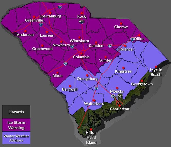
-An Ice Storm Warning is in effect for the Upstate, Catawba Region, most of the Central Savannah River Area (CSRA) and Midlands, and the northern part of the Pee Dee region.
-A Winter Weather Advisory is in effect for the rest of the Pee Dee except for coastal Georgetown County, and for inland areas of the Lowcountry.
-Sleet and freezing rain will spread over the Upstate and Catawba Region tonight. Sleet is likely to accumulate an inch or so along and north of I-85 from Greenville northeastward before a change to freezing rain, while areas southeast of I-85 see less sleet with an earlier transition to freezing rain. Freezing rain and drizzle continue through Sunday before ending Sunday night. Tree and power line damage is likely to be widespread, causing potentially long-lasting power outages. Travel will be dangerous through at least Monday morning. A windy period Sunday night and Monday behind the storm will exacerbate the potential for tree and power line damage.
-Across the northern CSRA, the northern Midlands, and northern Pee Dee, the storm begins with sleet for a while Saturday evening, with a small accumulation possible. However, freezing rain will dominate most of Saturday night and Sunday. Widespread tree and power line damage is possible, and travel will be hazardous, potentially through Monday morning. Power outages could be lengthy. A windy period Sunday night into Monday may exacerbate the potential for tree and power line damage.
-Along I-20, ice buildup will lead to scattered tree and power line damage, and travel will become hazardous, especially on elevated roads. Temperatures rise above freezing Sunday afternoon, ending the threat for icy travel, with intermittent light rain or drizzle the rest of the day. Sunday night brings a round of more substantial rain and perhaps a thunderstorm.
-Areas south of the I-20 Corridor in the CSRA, Midlands, and Pee Dee will see a lesser ice buildup Saturday night through Sunday morning, but isolated tree and power line damage is possible. Roads and sidewalks will have icy patches, especially on elevated surfaces. Temperatures will likely rise above freezing by midday Sunday, ending the threat for icy travel, with intermittent light rain or drizzle the rest of the day. Sunday night brings a round of more substantial rain and perhaps a thunderstorm.
-The inland Lowcountry and Grand Strand primarily see rain with temperatures above -freezing Saturday night through Sunday. However, freezing rain will occur over the region for a time Saturday night and early Sunday with temperatures dropping to near freezing. Elevated road surfaces can remain slippery for a few hours, but the risk of tree and power line damage is low.
-The coastal Lowcountry will most likely remain above freezing and see only rain.
The Lowcountry will see thunderstorms late Sunday and Sunday night as warm air surges into the region; there may even be a risk of isolated damaging winds and isolated tornadoes.
-Continued cold early next week behind the storm will lead to slow melting where there is a substantial sleet accumulation. Burst pipes and water mains will be a concern over much of the state, and those with no power or a backup heating source will experience severe hardship.
We remain on track for a damaging winter storm over much of South Carolina tonight through Sunday night. Some of you have already seen a flurry, a few ice pellets (sleet), or a touch of rain or freezing rain. Precipitation will turn more widespread and heavier as we go into this evening.
Here’s a sleet accumulation map from the National Weather Service (NWS):
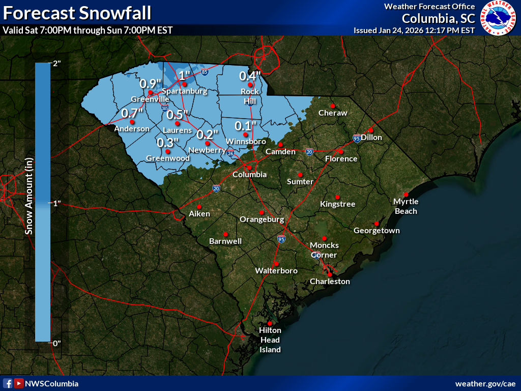
Yes, it says snow, but sleet counts as snow for this purpose, and it’s not gonna snow. Well, maybe a tiny bit north of Highway 11 in the Upstate, but nothing significant. At least 99 percent of solid precipitation will be sleet
Now, for the NWS’s ice buildup forecast:
.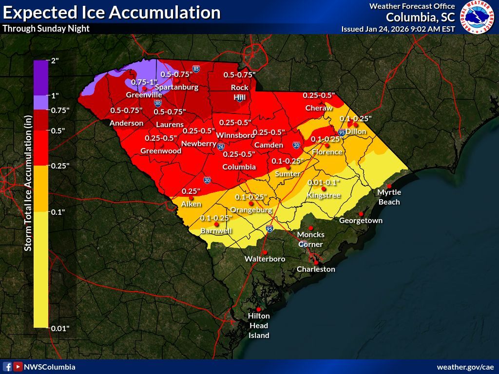
As I said on Friday, this is going to be a terrible ice storm for the Upstate and vicinity. A lot of people will lose power, and power could stay off for a while because of the volume of work needed to restore power to everyone.
Extreme cold will settle in behind the storm for early next week, and Monday night and Tuesday morning will bring the Upstate the coldest air we’ve seen in years; mighty cold over the rest of the state as well:
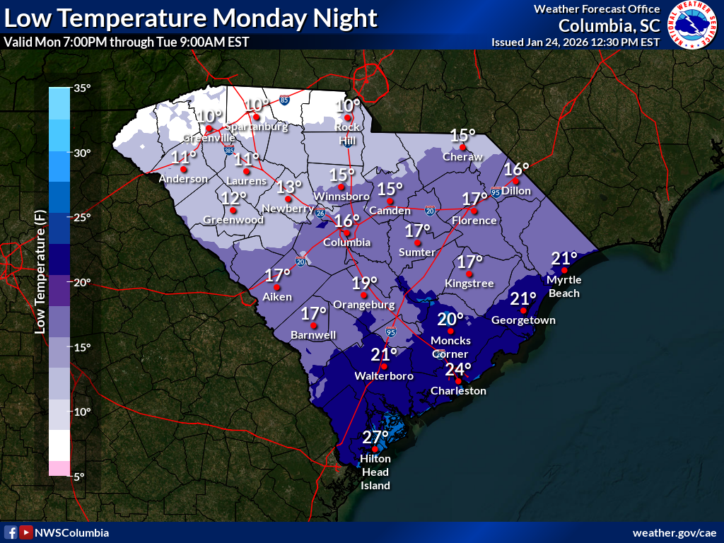
The extreme cold will slow the melting of the glacier covering the Upstate early next week. Slippery travel will probably linger into Tuesday morning.
Time’s almost up for preparing. It’s nearly time to hunker down. But there are still a few more things you can do. Here are a few thoughts:
If you have dirty laundry piled up, maybe do that soon, before the power goes out.
Same for the dishwasher, if it’s full of dirty dishes.
Are all your phones, tablets, battery packs, handheld game consoles, and so forth fully charged?
You didn’t forget your pets, did you? The pups and floofballs need access to food, water and a cozy spot to stay on Monday night (indoors if they can behave long enough).
You may want to keep your faucet dripping Monday night; make sure your home’s pipes are adequately insulated.
OK, that’s it. This will be my last update for this storm unless something unexpected happens. Play it smart and safe, y’all.
WEATHER ALERT: Winter Weather Update, 1/24/2026