

By Frank Strait
Severe Weather Liaison
S.C. State Climate Office
Key Points:
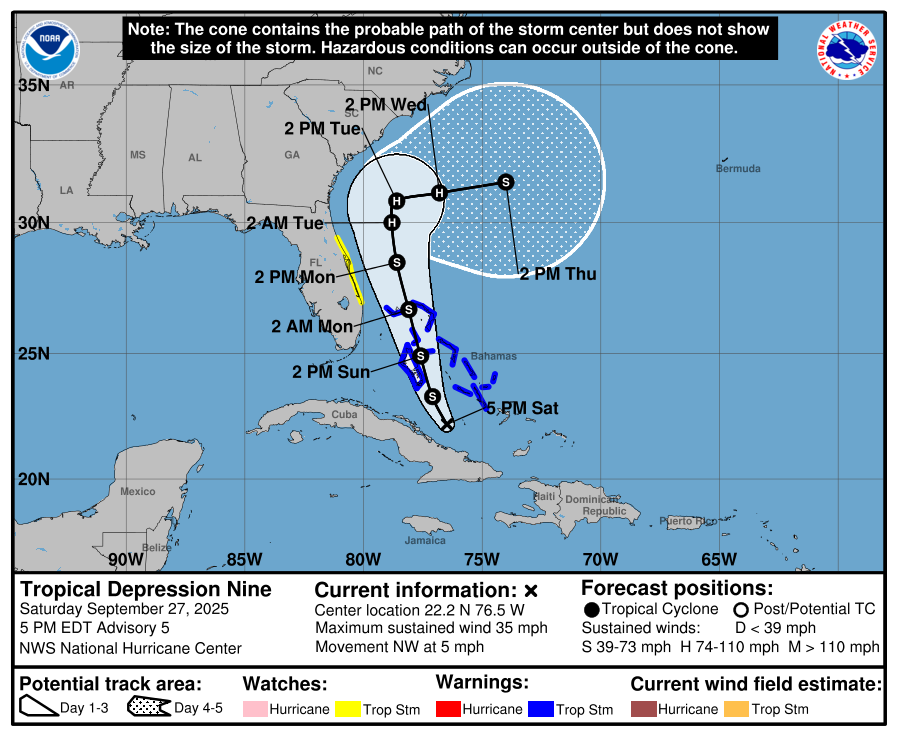
The forecast is clearer now for Tropical Depression Nine, which is likely to become Tropical Storm Imelda soon. The forecast calls for an offshore storm track, but some uncertainties remain.
Tropical Storm or Hurricane Watches may be issued tonight or early Sunday, unless the forecast situation improves further.
Storm preparation remains a necessity in parts of South Carolina.
Strong tropical storm or hurricane conditions remain possible for our coastal counties. Damaging winds, storm surge, excessive rainfall, and isolated tornadoes will all be threats, though the level of risk remains uncertain. We’re also likely to see beach erosion.
Inland areas now look less likely to see damaging winds, but excessive rainfall and localized flooding remain a threat for Monday through Tuesday.
The Upstate appears likely to see little impact from Imelda, but some areas will see heavy rainfall that can lead to isolated flash flooding.
Seas and surf along our coast will be dangerous all week long due to swell impacts from Hurricane Humberto and from Imelda-to-be.
The worst conditions should occur Monday night through Tuesday night, but timing uncertainties mean the storm’s duration could be longer.
Some aspects of the forecast have changed since Friday, as our computer model guidance has come into much better agreement on the behavior of the storm previously known as Invest Area AL94, now called Tropical Depression Nine, and will likely soon be named Tropical Storm Imelda. The forecast still calls for major impacts along our coast, but the trends have been our friend over the last 24 hours, and the situation looks less dire than it did a day ago.
The National Hurricane Center (NHC) forecast calls for Imelda-to-be to strengthen into a strong tropical storm or hurricane before reaching our coastal waters, then taking a right turn and drifting slowly near our coast for a while, following the hybrid scenario presented on Friday.
While we have a much better idea of how things are going to play out with Imelda-to-be, there is still uncertainty in the forecast. NHC uses the uncertainty cone you see in the graphic above for a reason. Keep in mind that the cone refers to the area where the center of a storm is most likely to track (based on their forecast verification statistics, the center tracks within the cone two out of three forecasts). So, there remains a good bit of wiggle room in the forecast, with serious consequences should Imelda-to-be behaves differently than forecast (and it probably will — NHC forecasts are excellent but they whiff now and then just like Aaron Judge strikes out sometimes despite having Major League Baseball’s best batting average … and on base percentage … and slugging percentage … and on-base slugging percentage).
So, while a track well offshore that continues to bring our coastal areas heavy rain and flooding risk, along with a low-end wind and storm surge risk appears likely, there remains a best-case scenario with the storm potentially going to the right of the forecast track and a worst-case scenario with the storm going on the left side of the cone.
No matter the track, our coastal waters are going to be put in a rather angry state as Imelda-to-be winds up over the next couple of days and big swells arrive from Hurricane Humberto, which has gone into absolute Beast Mode as a Category 5 hurricane northeast of Puerto Rico. Our coastal waters will be dangerous for swimmers, surfers, and mariners all week long.
Coastal residents need to continue preparing for a hurricane, in case the worst-case scenario comes to pass. You’re still in a ‘better safe than sorry’ situation. While the wind and storm surge impacts may turn out to be not terribly serious, people along the coast still have a significant risk. These areas are also likely to experience heavy rainfall from Monday into Tuesday, and there’s a good chance of an extreme rain event with local double-digit rainfall totals.
Elsewhere, those inland, up to a line from Rock Hill to Aiken, should be ready for potentially excessive rainfall and resultant flash flooding on Monday and Tuesday (despite drought conditions over much of this area). The rest of the state may see isolated flash flooding from downpours on those days.
There are two other bits of good news: astronomical tides are low because the moon is entering its first-quarter phase, and Imelda-to-be is moving more slowly than expected, giving us more time to prepare for the risk of any damaging winds that may occur along our coast. High winds, assuming they occur, are unlikely to begin before nightfall on Monday.
If you need help with your storm preparations, SCEMD has you covered with their hurricane.sc website. Keep on preppin’ and I’ll update you again on Sunday, when the forecast clarity should be further improved.


