By Frank Strait
Severe Weather Liaison
S.C. State Climate Office
S.C. Department of Natural Resources
Key Points:
-A winter storm is on the way to areas north of I-20 starting Friday afternoon and ending early Saturday.
-Confidence is high that the storm will occur, but lower on where the worst of the storm will occur and how severe those impacts will be. There is also less confidence about precipitation type (snow versus sleet and freezing rain).
-The Upstate will see the most snow and sleet and the most significant travel impacts. Roads will be very slippery later Friday through Saturday morning.
-Sleet and freezing rain dominate in a band from the northern Central Savannah River Area to the Catawba River Area and possibly the upper Pee Dee region. There may be enough ice buildup to strain trees and power lines in this area. Travel will be treacherous with untreated bridges and overpasses slick; other road surfaces might become icy as well.
-Areas along I-20 see limited travel impacts. A brief period of snow and sleet may occur at the onset of the storm later Friday, but freezing rain and rain will be dominant. Some bridges and overpasses may become icy.
-Most areas south of I-20 see just a cold rain with temperatures above 32°.
-Cold and dry weather will follow the storm, but days with temperatures in the 40s should result in steady melting. However, temperatures drop well below freezing at night and some icy areas are likely in the Upstate Sunday morning due to refreezing; a few icy patches are possible again Monday morning.
We remain on track for a winter storm to affect the northern part of the state Friday and Friday night, with the worst impacts in the Upstate. Little has changed since Tuesday, and unfortunately, that includes the confidence level. While the models generally agree about how the storm will behave, many devils are in the details. I’ll be as specific as I can about precipitation amounts, but the situation is fluid.
The storm is currently spinning over northwestern Mexico (and is responsible for the Santa Ana winds in California that are helping to cause the awful wildfires there). It will reach the Gulf of Mexico by Thursday night and pass along our coast Friday night and early Saturday.
Precipitation could start as early as late morning along the rivers dividing us from the peach posers and should cover the northern half of the state by dark. Areas further south may not see anything falling until it gets dark, but it will be all rain or almost all rain in those areas.
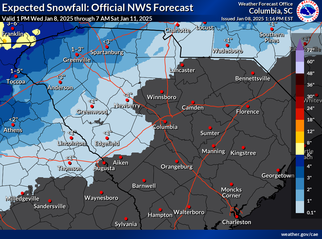
The Upstate will see the most substantial snow from this storm. The National Weather Service (NWS) forecasts show about 1-3 inches along I-85, with the potential for more to the northwest (maybe 5-6 inches in the highest spots), but amounts trail off going southeastward.
Of course, if you’re traveling into vinegar-and-tomato sauce land, expect more snow, with several inches in those high elevations. You picked a good time if you have a southern Appalachian ski trip planned for this weekend.
Despite the track of the surface storm center going by to the south of most of us, a layer of above-freezing air aloft will spread over most or all of South Carolina during the storm. So, except for maybe a small area in the far northwest, some sleet and freezing rain will mix with the snow in the Upstate. This will make roads quite slick and result in difficult travel Friday night and early Saturday.
We remain concerned about significant ice buildup somewhere between I-85 and I-20. We’re still unsure exactly where it will be, but the most likely area is from Abbeville and McCormick Counties northeastward toward Chester, Lancaster, and perhaps Chesterfield Counties. The ice buildup could reach a quarter-inch in this area, enough to stress trees and powerlines. The amount of ice accretion will depend on how much of what falls is freezing rain; more in the way of sleet and snow could be a saving grace. I don’t think we’ll see widespread power outages and downed trees, but there can be a few here and there if the worst comes to pass. Trees in the Upstate and Central Savannah River Area may be weakened by Helene, so don’t be surprised if there is a little more tree damage in that area. We’ll have travel impacts in this area, too, especially on the elevated road surfaces, but all the roads could become icy and dangerous.
As you look further south toward I-20, any snow and sleet should be confined to a brief period (an hour or two at most) at the onset, with rain and freezing rain dominant. We may see the freezing rain cause slippery bridges and overpasses, at least for a few hours.
South of I-20, it’s looking like an all rain or almost all rain event. Areas closer to I-20 may see a sprinkle of snowflakes or ice pellets at the onset but I don’t think it will stick. Those areas might see 32° and rain for a while and icy patches on elevated roads, but I don’t think there will be much impact on travel. You’ll have to be very careful if you’re out. The rest of the area sees a cold but needed rain with temperatures above freezing.
Of course, there is some wiggle room in this forecast; more or less mixing may occur along I-85 and it could end up being either mainly snow with more than currently forecast falling, or it may turn out to be more a sleet and freezing rain event with minimal snow accumulations. So, keep an eye out for changes to the forecast. The expected area where the worst of the ice occurs and how far south the travel impacts reach may also change.
Another push of cold Canadian air will follow the storm for this weekend. It will remain dry for a while once precipitation moves out Saturday morning. Highs over the weekend will be in the 40s for the most part across the state, with lows in the teens and 20s. So, we’ll melt snow and ice by day but freeze it back up at night. So, beware of slick spots Sunday morning where a substantial amount of snow and ice falls, and maybe again Monday morning in parts of the Upstate if we don’t melt it all away before it gets dark on Sunday.
Bottom line: We’re going to see a winter storm over much of the state that will make travel dangerous across the Upstate and vicinity. At least it’s coming on a Friday night when there is less need to travel, though it will affect Friday’s drive home in some areas. It’s not a major, historic storm and most places that see substantial snow and ice will return to normal by Sunday (Monday at the latest). So, grab what you need and want ahead of the storm so you don’t have to travel, but you don’t need to be a hoarder. If you do have to travel in the storm … well, think twice, but be extremely careful if you do. As always, winter storm prep advice is available from SCEMD’s SC Severe Winter Weather Guide.


