

By Frank Strait
Severe Weather Liaison
S.C. State Climate Office
S.C. Department of Natural Resources
Key Points:
Tropical Storm Milton, which formed as Tropical Depression 14 this morning in the Gulf of Mexico will track toward the east-northeast toward Florida in the coming days, reaching Central Florida as a hurricane on Wednesday.
Potential impacts to South Carolina appear limited to coastal rain and gusty winds on Wednesday into early Thursday. Tropical storm conditions along our coast during this time appear to be the worst-case scenario.
Uncertainty is higher than usual for storms in their formative stages, and a track more to the left would result in stronger and more widespread wind and rain impacts for us, while a track more to the right may result in no wind and rain impacts. However, all track possibilities will result in dangerous surf and marine conditions along our coast starting as early as Tuesday.
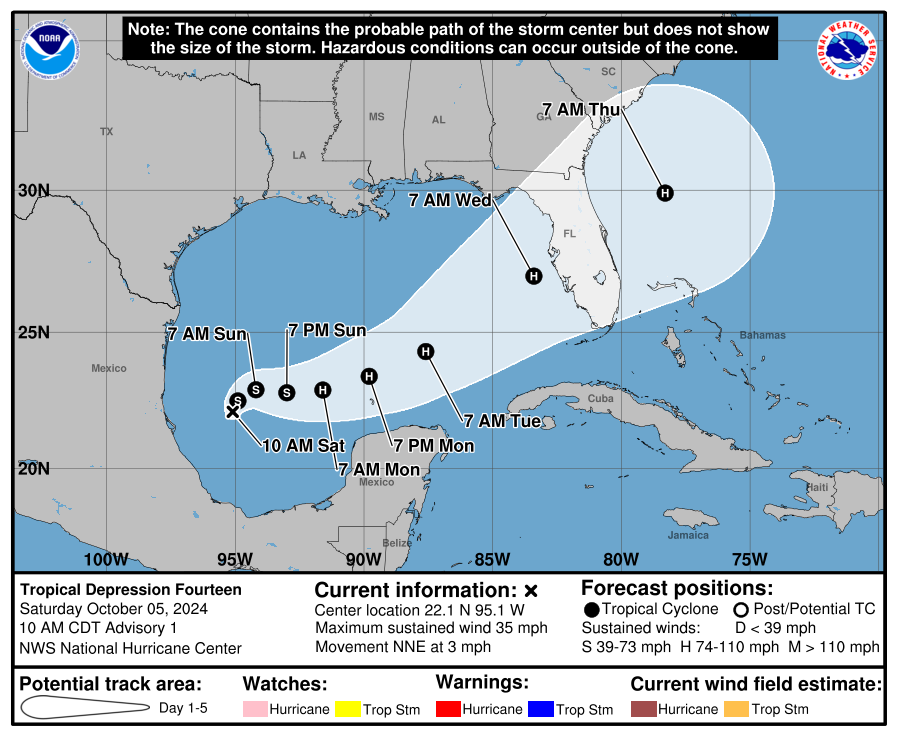
Things are progressing faster than expected in the Gulf of Mexico. Over the last 12 hours, a surface circulation formed east of Tampico, Mexico, with persistent thunderstorms around it. So, as of 11 a.m. today, Tropical Depression 14 has formed, which became Tropical Storm Milton shortly before I hit the ‘send’ button for this.
The first uncertainty cone from the National Hurricane Center (NHC) indicates the most likely track will be toward the east-northeast as it strengthens, into Central Florida on Wednesday as a Category 2 hurricane, possibly stronger, then off the Southeast Coast on Thursday.
On this most likely track, we would see low-end wind and rain impacts in South Carolina; heavy rain totaling 1-3 inches and winds gusting in the 40-50 mph range is possible along our coast Wednesday night into Thursday. Lesser impacts could extend inland as far as I-20. Winds will be offshore unless the forecast track is way off, and that would result in no storm surge. The forecast track is not conducive for a tornado risk in South Carolina.
However, uncertainty is higher in these early stages of dealing with Milton. A track further to the right could spare us from seeing any wind and rain. A track more to the left would result in heavier rain and stronger winds along our coast, with more of the state receiving some wind and rain impacts. We’ll certainly deal with dangerous surf and marine conditions along our coast on Wednesday through at least Friday once the storm emerges from Florida over the Atlantic.
I know some of y’all are model watchers. Computer models are prone to major errors with storms in their formative stages. We’ll get better guidance from those models tonight and especially Sunday.
We continue to track Hurricane Kirk and Tropical Storm Leslie over the central and eastern Atlantic, along with more tropical waves emerging from Africa. Neither Kirk nor Joyce are concerns for us other than the swells they generate. It’s far too soon to say for sure how the other features we’re watching might affect us, if at all.
As always, I urge you to maintain your readiness for storms, and those along our Coastal Plain should ensure their disaster kits are fully stocked in case Milton ends up closer than expected while seeking his red Swingline stapler. Visit hurricane.sc for storm prep advice.


