By Frank Strait
Severe Weather Liaison
S.C. State Climate Office
S.C. Department of Natural Resources
Last night ended up being a rough night. I don’t know about y’all, but I was up at about 4 a.m. thanks to the wind and rain. I don’t have any significant damage in my neighborhood but I know many neighborhoods do. Around 1.3 million electric customers were without power this morning for a time, though that number is dwindling as crews work hard to restore service. The Central Savannah River Area took it on the chin with wind. You only have to go yards across the Savannah River to Augusta Regional Airport to find an 82 mph wind gust this morning, and gusts of 60-70 mph were common over the Upstate, Midlands, and Lowcountry. Flooding has been and will remain a problem throughout the Upstate, and several of our rivers will be in flood for days. A slew of tornado warnings were needed this morning. However, it will take time for the National Weather Service to survey areas of potential tornado damage and we won’t know how many tornadoes hit until the surveys are complete. A small storm surge affected our coast and occurred close enough to high tide to cause coastal flooding.
Helene will be captured by an upper-level low spinning over the Tennessee Valley, and it’s in this area where Helene will become non-tropical and rain itself out. The upper low will wander northeastward slowly and finally move out of the way by Wednesday. It will spin a few showers into the Upstate over the next few days, but we won’t see any more widespread heavy rain. In fact, Palmetto State weather looks mainly dry for several days once Helene gets out of the way today. A cold front will push the upper low and Helene’s remnants away to the northeast next week, but it will only cause stray showers, and we likely won’t have any more noteworthy rain until at least next weekend.
The feast or famine pattern with rain here continues. We return to famine mode for a while starting this weekend.
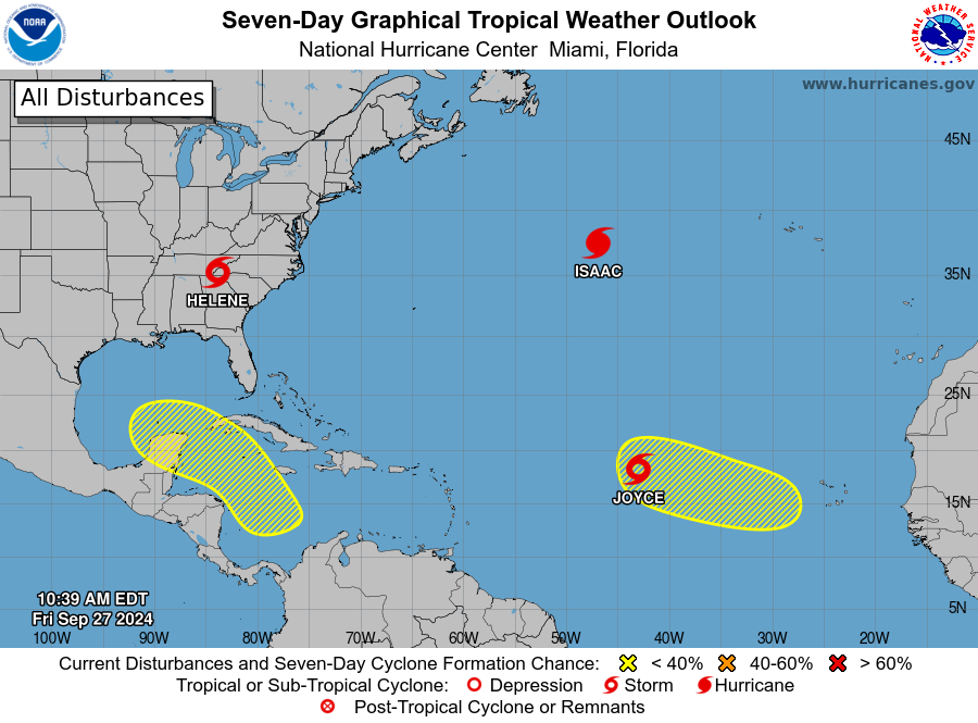
Looking at the Atlantic again, we have two other tropical cyclones to track. Neither are concerns for us. Hurricane Isaac to the northeast of Bermuda is moving east and will stay far away. Newly named Tropical Storm Joyce over the middle of the tropical Atlantic will turn north this weekend and remain relatively weak.
There is one other feature to watch over the eastern tropical Atlantic. It’s the tropical wave that just emerged from West Africa Thursday. It will track westward over the next few days and it has a chance to develop early next week over the middle of the tropical Atlantic. However, early signs are that it will turn north and stay far away like Joyce and Isaac.
Not much is happening today in the other yellow area on NHC’s outlook, but it will be an area to watch next week. As we saw with Helene, we expect to see one of those Central American Gyre features form next week and potentially spawn a tropical cyclone in the Gulf of Mexico later next week or next weekend. It’s too early to say whether there will be any eventual impacts in South Carolina from it or how significant they might be.
We’re a bit battered and bruised this morning but we’ll be getting up and dusting ourselves off like we always do. At least we have a spell of mainly quiet weather to help with recovery efforts.
WEATHER REPORT: Helene Moving On – Good Riddance!