By Frank Strait
Severe Weather Liaison
S.C. State Climate Office
S.C. Department of Natural Resources
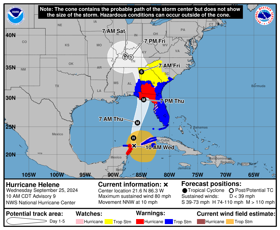
A Tropical Storm Warning is in effect for the South Carolina coast south of South Santee River and inland Charleston, Berkeley, Beaufort, Jasper, and coastal Colleton Counties. A Tropical Storm Watch is now in effect for the coast up to Little River Inlet and inland areas of the state generally along and southwest of the I-26 Corridor.
Recent changes to the Helene track forecast by the National Hurricane Center include a slower and slightly further west track.
Forecast rainfall amounts have increased, and there is potential for widespread flash flooding over much of the state. The primary concern area is the Upstate, which will see heavy rain along a stationary front through tonight, followed by extreme rainfall from Helene Thursday night and Friday. There is a moderate to high risk for flash flooding and a risk for moderate to major river flooding. Many areas that rarely flood will likely flood in the coming days. There may even be landslides in the higher ground.
Flash flooding may also be significant from Helene’s rain in the Central Savannah River Area and as far east as the I-77 Corridor farther north. Over the rest of the state, heavy rainfall will cause isolated flash flooding. The rain will result in rising rivers this weekend, and river flooding will be a concern along many of the state’s rivers behind Helene.
The concern for Helene to spawn tornadoes over most of the state has increased, especially for the Lowcountry. The timing of the greatest tornado threat, which will come Thursday night and the early morning hours of Friday, is even more concerning.
Wind remains a concern for parts of the state; locally damaging wind may result in isolated tree and power line damage, mainly to the southwest of I-26. The damaging wind potential would be greater and more widespread should Helene track on the east side of the current uncertainty cone.
Helene will produce a storm surge of 1-3 feet for the coastal Lowcountry. A small storm surge of a foot or so is possible further north along the coast.
Helene is now a hurricane with 80 mph maximum sustained winds, centered just east of Cancun, Mexico.
The latest NHC experimental forecast cone, watch, and warning graphic shows the extent of Tropical Storm Watches and Warnings in our state.
Helene will cause all four of the usual tropical cyclone impacts to some or all of South Carolina. First, we must address the threat of extreme rainfall and flooding. Below are the Excessive Rainfall Outlook graphics from the Weather Prediction Center (WPC) to break down the risk for heavy to extreme rainfall and flooding through Friday.


A front that will become stationary over much of the Upstate will cause a predecessor heavy rainfall event through tonight, with the potential for significant flash flooding over the western Upstate and isolated flash flooding in other parts of the state. Extreme rain from Helene will affect much of the state Thursday into Thursday night, resulting in widespread flash flooding for the Upstate, especially areas that get heavy rain through tonight. In that area, some areas that see flooding only in the most extreme rain events will flood, and the high-risk area indicates the risk for severe flash flooding and should be taken very seriously. Flash flooding may be widespread and significant in the ‘Moderate Risk’ areas. In the green and yellow areas, there can be isolated flash flooding from heavy rain, with yellow areas at a somewhat higher risk.
River flooding is going to be a problem in the Upstate as well; be prepared for moderate to major river flooding in this area. This will flow downstream, of course, and the rest of the state will get soaking as well, so we will see river flooding become a problem over most of the state’s rivers as we go into the weekend.
Now, to address the damaging wind risk. Helene will have an unusually large field of strong winds on its east side so South Carolina will get a taste of the strong wind.


The slightly westward shift of the forecast track has reduced my concern for strong winds a bit. However, peak gusts in the 50-55 mph range over areas near the Savannah River will still be enough to cause some downed trees and power lines. It wouldn’t shock me if someone in the western Upstate or coastal Lowcountry had a 60 mph gust. Areas farther to the east will see less wind, but the wind combined with heavy rain might cause isolated tree and power line damage. Should Helene track farther east than expected, the concern for damaging wind will increase.
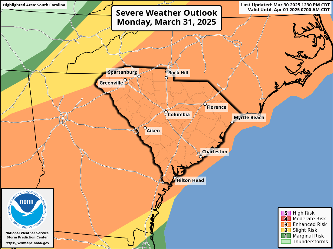
The tornado risk is looking potentially serious over parts of the state. Here’s the Storm Prediction Center’s Severe Weather Outlook graphic for Thursday and Thursday night to illustrate the concern:

The level 3 of 5 ‘enhanced risk’ area over the Lowcountry is concerning. I’ve said before that concern for a more serious severe storm outbreak hits harder when you see SPC has us in level 3 and up areas. I’ve read that they are evaluating whether to expand that further north and northeast, They might well have to as that area is going to have an unusually favorable setup for tropical tornadoes Thursday and Thursday night. At least a few tornadoes further north and west are likely but will be more isolated. While there might be isolated severe storms with a couple of tornadoes on Thursday, the main time of concern will be Thursday night as Helene barrels northward through the Southeast, especially late at night and the wee hours of Friday.
A tornado outbreak at night is never a good thing. Usually, people are trying to sleep and many miss warnings. So, it’s important to have tornado preparations in place ahead of Helene. Decide on your best shelter area in advance, as you might not get much lead time. Tropical tornadoes often hit fast without much lead time on warnings. Also, be sure you have at least a few ways to receive tornado warnings, and make sure one of them will make enough noise to wake you if you’re sleeping. More tornado preparation advice is available from the National Weather Service.
Oh, it’s worth mentioning that any storm along the stationary front in the Upstate and vicinity this afternoon and tonight can be locally severe with damaging wind; an isolated tornado can’t be ruled out.
Finally, storm surge:

The current forecast from NHC allows for a 1-3 foot storm surge along and south of South Santee River. It wouldn’t surprise me if they extended this further north in time, but the Lowcountry has the greater storm surge risk. However, timing, which is a little uncertain still, will be key. A 2-3 foot storm surge that hits at high tide would be enough for moderate to major coastal flooding, but if it hits at low tide or between the tides, there may be little or no impacts from the surge. Of course, especially for the Charleston area, should heavy rainfall occur right at high tide with a coinciding storm surge, the coastal flooding gets even worse.
Helene is coming. The worst will pass to our west, but we will see major impacts in South Carolina. So, please prepare. If you need advice, SCEMD has you covered at hurricane.sc.
Helene To Bring SC Flooding Rain, Tornadoes


